
Abraham Ortelius (/ɔːrˈtiːliəs/; also Ortels, Orthellius, Wortels; 4 or 14 April 1527 – 28 June 1598) was a cartographer, geographer, and cosmographer...
25 KB (2,718 words) - 12:24, 29 May 2024

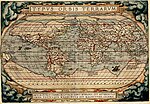
World") is considered to be the first true modern atlas. Written by Abraham Ortelius, strongly encouraged by Gillis Hooftman and originally printed on 20...
11 KB (1,167 words) - 18:25, 20 May 2024
World") is considered to be the first true modern atlas. Prepared by Abraham Ortelius and originally printed on May 20, 1570 in Antwerp, it consisted of...
74 KB (8,674 words) - 22:43, 5 June 2024
Marcel Van den Broecke (section Ortelius)
the life and works of the Antwerp cartographer Abraham Ortelius (1527-1598). In 1996 he published Ortelius Atlas Maps, with in 2011 a new edition, rewritten...
8 KB (1,022 words) - 09:24, 29 December 2023

Abraham Ortelius. Alongside the sumptuous maps of that book Mercator's un-ornamented new maps looked very unattractive. Despite the death of Ortelius...
100 KB (12,841 words) - 15:08, 13 June 2024

collection of maps Theatrum Orbis Terrarum by the Brabantian cartographer Abraham Ortelius printed in 1570.[citation needed] Atlases published nowadays are quite...
12 KB (1,327 words) - 22:35, 7 May 2024
Arthur Holmes proposed mantle convection for that mechanism. Abraham Ortelius (Ortelius 1596), Theodor Christoph Lilienthal (1756), Alexander von Humboldt...
45 KB (4,762 words) - 14:53, 2 June 2024

Europe and the Mediterranean Sea from 1513 Map of Europe from 1570 Abraham Ortelius' map of Europe from 1595 Gerardus Mercator's map from 1595 Expeditions...
14 KB (1,209 words) - 04:46, 28 April 2024
region already well known to the Europeans (e.g., just Guangdong on Abraham Ortelius' 1570 map), and to place the mysterious Cathay somewhere inland. It...
28 KB (3,142 words) - 05:43, 9 June 2024

1531, and the Flemish cartographers Gerardus Mercator in 1538 and Abraham Ortelius in 1570. Schöner's concepts influenced the Dieppe school of mapmakers...
46 KB (5,848 words) - 21:19, 6 June 2024

Pigafetta published an Italian version of the Theatrum Orbis Terrarum of Abraham Ortelius. Pigafetta's Regnum Congo plays an important role in H. P. Lovecraft's...
4 KB (471 words) - 15:57, 15 December 2022

is a map of Africa published by Abraham Ortelius in 1570. It was engraved by Frans Hogenberg and included in Ortelius's 1570 atlas Theatrum Orbis Terrarum...
12 KB (1,342 words) - 20:46, 22 October 2023

Onegaborg, known from a map from 1592 of the Flemish cartographer Abraham Ortelius, and hence translated to Finnish as Äänislinna, a name used during...
29 KB (2,672 words) - 21:34, 22 May 2024
Mercator (Netherlands, 1512–1594) Sebastian Münster (Germany, 1488–1552) Abraham Ortelius (France, 1527–1598), generally recognized as the creator of the first...
30 KB (3,143 words) - 15:05, 10 June 2024

land of the South"), as seen in the Theatrum Orbis Terrarum map by Abraham Ortelius (1570). During the 19th century, terra incognita disappeared from maps;...
5 KB (580 words) - 03:02, 8 April 2024

Italian cartographer Giacomo Gastaldi in 1562. It appeared on maps by Abraham Ortelius (1564), Bolognini Zaltieri (1567) and Gerardus Mercator (1567). The...
4 KB (455 words) - 12:24, 11 October 2023
the original source that is now expected. An early example is the Abraham Ortelius map (1598). Innovations during the 18th century, especially in the...
6 KB (643 words) - 10:55, 28 May 2024
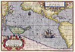
considered an important advancement in cartography. This map was drawn by Abraham Ortelius in 1589, based upon a map of America from the same year that was drawn...
1 KB (114 words) - 07:08, 4 June 2024

on public display. The map was copied for Brabantian cartographer Abraham Ortelius and published shortly after his death in 1598. A partial first edition...
19 KB (2,360 words) - 18:52, 30 May 2024
The first modern atlas was the Theatrum Orbis Terrarum, published by Abraham Ortelius, which included a world map that depicted all of Earth's continents...
30 KB (3,537 words) - 23:24, 7 June 2024

Oxford English Dictionary, Oxford: Oxford University Press, 2022. Ortelius, Abraham (1570), "Americae sive Novi Orbis Nova Descriptio [New Description...
112 KB (12,511 words) - 18:09, 11 June 2024
of the Virgin was originally owned by Abraham Ortelius and may have been commissioned by him. In 1574, Ortelius asked Philips Galle to reproduce the painting...
8 KB (845 words) - 11:31, 11 February 2024

Jacobus van Meteren's nephew, Leonard Ortels (†1539), the father of Abraham Ortelius (1527–1598), humanist geographer and cartographer. Although Coverdale...
5 KB (487 words) - 05:30, 13 April 2024

Map of Italy with Aeaea marked south of Rome (Abraham Ortelius, 1624)...
8 KB (1,039 words) - 15:30, 14 June 2024

famous Ortellius family of mapmakers, and nephew of the cartographer Abraham Ortelius. As a historian Van Meteren was special in that he was not merely a...
9 KB (1,205 words) - 03:32, 24 November 2023

Ioannes Basilius Magnus Imperator Russiae, Dux Moscoviae, by Abraham Ortelius (1574)...
85 KB (10,094 words) - 21:47, 9 June 2024
The first modern atlas was the Theatrum Orbis Terrarum, published by Abraham Ortelius, which included a world map that depicted all of Earth's continents...
38 KB (4,138 words) - 06:10, 12 May 2024

Vlissingen, Netherlands. She was renamed Ortelius and registered in Cyprus.[5] On 16 January 2014, Ortelius was scheduled to sail for a 10-day Antarctic...
6 KB (265 words) - 17:30, 10 July 2022
1570 map by Abraham Ortelius depicting Terra Australis Nondum Cognita as a large continent on the bottom of the map and also an Arctic continent...
20 KB (2,267 words) - 01:54, 24 May 2024

Map of Ancient Thrace made by Abraham Ortelius in 1585, stating both the names Thrace and Europe....
24 KB (2,820 words) - 21:54, 4 June 2024