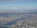
The Arakawa River or Ara River (Japanese: 荒川, Hepburn: Arakawa, "kawa" (川) already means "river") is a 173-kilometre (107 mi) long river that flows through...
4 KB (385 words) - 21:31, 1 May 2024
Arakawa River (荒川) or Ara River may refer to: Arakawa River (Kanto), which flows from Saitama Prefecture and through Tokyo to Tokyo Bay Arakawa River...
389 bytes (83 words) - 21:45, 13 July 2017
Niigata Arakawa, Saitama Rivers Arakawa River (Kanto), which flows from Saitama Prefecture and through Tokyo Arakawa River (Fukushima), which starts...
644 bytes (100 words) - 07:04, 14 September 2018

Arakawa (荒川区, Arakawa-ku) is a special ward in the Tokyo Metropolis in Japan. The ward takes its name from the Arakawa River, though the river does not...
14 KB (1,101 words) - 23:56, 21 May 2024

36.000°N 140.000°E / 36.000; 140.000 The Kantō Plain (Japanese: 関東平野, Hepburn: Kantō heiya), in the Kantō region of central Honshu, is the largest plain...
8 KB (1,079 words) - 06:11, 7 May 2024

between the Arakawa and Tama rivers in the Kantō region of Honshu, Japan. The plateau consists of an alluvial fan formed by the ancient Tama River, covered...
3 KB (276 words) - 02:15, 8 May 2024

The Kantō region (関東地方, Kantō-chihō, IPA: [ka(ꜜ)ntoː tɕiꜜhoː]) is a geographical region of Honshu, the largest island of Japan. In a common definition...
21 KB (1,965 words) - 03:29, 7 May 2024

The Great Kantō earthquake (関東大地震, Kantō dai-jishin, Kantō ō-jishin) also known in Japanese as Kantō daishinsai (関東大震災) struck the Kantō Plain on the main...
47 KB (4,987 words) - 08:56, 15 April 2024

a small strip of land between the Sumida River and Arakawa River and a larger area north of the Arakawa River. The ward is bordered by the cities of Kawaguchi...
15 KB (1,271 words) - 19:41, 17 May 2024

The Kantō Massacre (關東大虐殺, Korean: 간토 대학살) was a mass murder in the Kantō region of Japan committed in the aftermath of the 1923 Great Kantō earthquake...
41 KB (4,643 words) - 05:15, 21 May 2024

Saitama Prefecture (category Kantō region)
sandwiched by the Furutone River to the east and the Arakawa River to the west. The western side of the prefecture belongs to the Kantō Mountain Range with Chichibu...
40 KB (2,710 words) - 20:41, 18 May 2024

war. The Arakawa River has inundated Kawaguchi countless times and ruined agriculture, which resulted in famines. Also, the 1923 Great Kantō earthquake...
18 KB (1,492 words) - 00:57, 16 April 2024

densely populated than Greater Tokyo.[citation needed] The South Kantō region (南関東, Minami Kantō) is a potentially ambiguous term. Informally, it may mean the...
32 KB (1,944 words) - 17:31, 26 April 2024

Kawagoe's location on the Arakawa River and near the Edo River were important elements of its tactical significance in defending the Kantō region from potential...
20 KB (1,536 words) - 08:43, 9 May 2024

to Horikiri Station, you have to walk on the bridge which overs Arakawa River (Kantō). Horikiri Shobuen: Five minute's walk will bring to Horikiri Shobuen...
3 KB (205 words) - 16:04, 17 August 2023
located in the Kantō Plain near the northern border of former Musashi Province, and made use of a bend in the former location of the Arakawa River as part of...
7 KB (794 words) - 01:22, 3 October 2023

its location on the Arakawa River and near the Edo River were important elements of its tactical significance in defending the Kantō from attacks from the...
4 KB (455 words) - 05:19, 31 March 2024

lowland created by the Arakawa River along with those created by small rivers such as the Moto-Arakawa River, Shiba River, and Ayase River. The rest of the...
27 KB (1,810 words) - 15:01, 8 May 2024

Tokyo (category Kantō region)
on the Kantō Plain with five river systems and dozens of rivers that expand during each season. Important rivers are Edogawa, Nakagawa, Arakawa, Kandagawa...
154 KB (12,455 words) - 19:53, 23 May 2024

clan (秩父氏) coming from the banks of the then-Iruma River, present day upstream of the Arakawa river. A descendant of the head of the Chichibu clan settled...
21 KB (2,611 words) - 06:04, 8 May 2024
Prefecture in the Kantō region of Japan. It was designated a National Historic Site of Japan in 1956. The Miyazuka Kofun is located on a river terrace in the...
4 KB (260 words) - 17:26, 25 October 2023

partially touches the left bank of the Arakawa River.The Kamo River and Shiba River flow through the city. The Ayase River forms the boundary to the east and...
11 KB (724 words) - 20:06, 15 April 2024

population of 3.7 million in 2023. It lies on Tokyo Bay, south of Tokyo, in the Kantō region of the main island of Honshu. Yokohama is also the major economic...
67 KB (5,284 words) - 16:21, 15 May 2024

Sumida and Arakawa are the major rivers, and form parts of its boundaries. Its neighbors are all special wards: Adachi to the north; Arakawa to the northwest;...
16 KB (1,405 words) - 09:59, 11 April 2024

Katsushika, Tokyo. The latter flows into the river Arakawa River, 2 km (1.2 mi) before Tokyo Bay. The course of the river was developed in Edo period (1603-1868)...
5 KB (297 words) - 17:18, 2 February 2024

largely mountainous and the population is concentrated in river terraces along the Arakawa River. It is Saitama's largest municipality in terms of surface...
25 KB (1,757 words) - 03:13, 21 April 2024

surrounded by the Arakawa River and the Fukasawagawa River, which contributed to its defenses. Due to its location at western edge of then Kantō Plain, Hachigata...
7 KB (700 words) - 05:55, 20 March 2024

is on the central reaches of the Arakawa River, which flows through the west of the city, whereas the Motoara River flows from the southeastern to central...
10 KB (609 words) - 07:39, 30 March 2024

The Kako River (加古川, Kako-gawa) is a river that flows through Hyōgo Prefecture, Japan. It is the largest river in Hyōgo Prefecture, both in terms of total...
19 KB (2,149 words) - 18:07, 14 April 2024
The total area is 32.22 km2. Itabashi lies on the Kantō plain. The Arakawa River, a major river, forms part of the boundary with Saitama Prefecture...
16 KB (1,293 words) - 17:59, 3 September 2023