
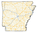
Arkansas Highway 197 (AR 197, Ark. 197, and Hwy. 197) is the designation for a state highway in the U.S. state of Arkansas. The route is split into three...
7 KB (476 words) - 07:52, 21 June 2023
of state highways in the U.S. state of Arkansas. The state does not use a numbering convention. Generally, the two-digit odd numbered highways run north–south...
244 KB (1,754 words) - 02:30, 7 April 2024

northeastern Logan County. Arkansas Highway 197 is Scranton's Main Street and leads southwest 10 miles (16 km) to Subiaco. Arkansas Highway 109 passes through...
7 KB (561 words) - 13:14, 15 May 2024

Highway 22 (AR 22, Ark. 22, and Hwy. 22) is an east–west state highway in the Arkansas River Valley. It is maintained by the Arkansas State Highway and...
19 KB (1,416 words) - 05:31, 14 September 2023
following highways are numbered 197: Quebec Route 197 Japan National Route 197 U.S. Route 197 Alabama State Route 197 Arkansas Highway 197 California...
2 KB (159 words) - 23:29, 4 April 2024

Routes 79 and 167 bypass the city center to the north and west, while Arkansas Highway 8 passes through the downtown area. US 79 leads northeast 42 miles...
24 KB (1,750 words) - 03:12, 23 June 2024

Highway 288 (AR 288, Ark. 288 and Hwy. 288) is a designation for two east–west state highways in northwest Arkansas. One segment of 10.03 miles (16.14 km)...
4 KB (234 words) - 16:35, 16 February 2024

Interstate 49 (I-49) is an Interstate Highway in the state of Arkansas. There are two main sections of the highway across different sides of the state....
42 KB (2,963 words) - 04:36, 19 May 2024

Arkansas Highway 10 is an east–west state highway in West Arkansas. The route runs 135.41 miles (217.92 km) from Oklahoma State Highway 120 near Hackett...
16 KB (961 words) - 16:29, 16 February 2024

near New Blaine: Anhalt Barn, on County Road 68 Old Arkansas Highway 22, part of AR 197, AR 197 Loop, and Rainwater Loop Elizabeth Hall, off AR 22 Farmer's...
7 KB (438 words) - 17:18, 22 April 2024

U.S. Route 271 (redirect from Arkansas Highway 271)
north–south United States highway. Never a long highway, it went from bi-state route (Arkansas and Oklahoma) to a tri-state route (Arkansas, Oklahoma and Texas)...
24 KB (1,146 words) - 02:03, 23 May 2024

Highway 78 (AR 78, Ark. 78, and Hwy. 78) is a designation for two state highways in the Arkansas Delta. One route of 24.03 miles (38.67 km) begins at Highway 306...
13 KB (1,045 words) - 16:31, 16 February 2024

U.S. Route 167 (redirect from Arkansas Highway 115 (1926))
north-south United States Highway within the U.S. states of Louisiana and Arkansas. It runs for 500 miles (800 km) from Ash Flat, Arkansas at U.S. Route 62/U...
71 KB (4,579 words) - 02:44, 4 June 2024

Highway 109 is a 44-mile-long (71 km) highway in western Arkansas. It runs from the Ouachita Mountains to the Arkansas River Valley in Logan and Johnson...
5 KB (307 words) - 16:32, 16 February 2024

Interstate 30 (redirect from Interstate 30 (Arkansas))
Interstate 30 (I-30) is a major Interstate Highway in the southern states of Texas and Arkansas in the United States. I-30 travels 366.76 miles from I-20...
52 KB (2,380 words) - 16:11, 19 June 2024

In Arkansas, the highway runs from the Louisiana state line near Doddridge to the Missouri state line near Bella Vista. In Texarkana, the highway runs...
41 KB (3,028 words) - 14:25, 22 April 2024

U.S. Route 49 (redirect from Arkansas Highway 6 (1960s))
United States highway. The highway's northern terminus is in Piggott, Arkansas, at an intersection with US Route 62/Highway 1/Highway 139 (US 62/AR 1/AR 139)...
40 KB (1,753 words) - 02:00, 8 June 2024

35°N 92°W / 35°N 92°W / 35; -92 (State of Arkansas) Arkansas (/ˈɑːrkənsɔː/ AR-kən-saw) is a landlocked state in the South Central region of the Southern...
146 KB (13,258 words) - 16:00, 18 June 2024
unincorporated community in Logan County, Arkansas, United States. Pleasant Hill is located on Arkansas Highway 197, 7.25 miles (11.67 km) east-northeast...
3 KB (77 words) - 03:42, 28 July 2023

Troy Lasater Service Station (category Gas stations on the National Register of Historic Places in Arkansas)
Station is a historic former automotive service station on Arkansas Highway 197 in New Blaine, Arkansas. It is a small single-story stone structure with a gabled...
2 KB (153 words) - 23:42, 25 April 2021
Freeborn T. Lasater House (category Houses on the National Register of Historic Places in Arkansas)
Freeborn T. Lasater House is a historic house at 494 Arkansas Highway 197 in New Blaine, Arkansas. It is a single-story masonry structure, built out of...
2 KB (127 words) - 05:36, 28 May 2022

entire route is in Miller County. The route was created by the Arkansas State Highway Commission on June 23, 1965. It began at Forest Avenue in Texarkana...
5 KB (373 words) - 11:36, 19 January 2024

U.S. Route 425 (redirect from Arkansas Highway 425)
(US 425) is a north–south United States highway that travels in the U.S. states of Mississippi, Louisiana, and Arkansas. It was first commissioned in 1989...
23 KB (1,157 words) - 09:25, 17 May 2024

U.S. Route 70 (redirect from Arkansas Highway 70)
Atlas (Map). Rand McNally. 2014. p. 82–83. Arkansas State Highway Map (Map) (2007 ed.). Arkansas State Highway and Transportation Department. The 2014 Road...
46 KB (5,177 words) - 21:55, 6 January 2024

Highway 198 (AR 198, Ark. 198, and Hwy. 198) is a designation for three state highways in the Upper Arkansas Delta, United States. One route of 2.45 miles...
6 KB (403 words) - 16:34, 16 February 2024

Interstate 49 (redirect from Interstate Highway 49 (Texas))
the original 1957 Interstate Highway plan, residents of Missouri, Arkansas, and Louisiana began campaigning for the highway in 1965 via the "US 71 - I-29...
62 KB (6,257 words) - 03:00, 15 June 2024

The Arkansas Delta is one of the six natural regions of the state of Arkansas. Willard B. Gatewood Jr., author of The Arkansas Delta: Land of Paradox,...
25 KB (2,838 words) - 03:13, 26 February 2024
four-lane bypass; the highway leads north 14 miles (23 km) to Pocahontas and southwest 40 miles (64 km) to Newport. Arkansas Highway 34 runs northeast out...
15 KB (1,092 words) - 04:15, 18 June 2024
Interstate 49 in Missouri (category Interstate Highways in Missouri)
beginning at the Arkansas state line, and ending at I-435 and I-470 on the southeast side of Kansas City. Upon completion, the highway will connect Kansas...
25 KB (1,227 words) - 22:22, 27 May 2024

highways serve Ashley County, the county has access to three United States highways (U.S. Route 82 [US 82], US 165, and US 425) and eleven Arkansas state...
65 KB (6,470 words) - 13:57, 9 May 2024