
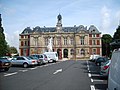
Caudebec-lès-Elbeuf (French pronunciation: [kodbɛk lɛ.z‿ɛlbœf], literally Caudebec near Elbeuf) is a commune in the Seine-Maritime department in the Normandy...
4 KB (204 words) - 11:07, 22 August 2024
Caudebec is a place name that may refer to two places on the river Seine in France: Caudebec-en-Caux, Seine-Maritime, France Caudebec-lès-Elbeuf, Seine-Maritime...
287 bytes (73 words) - 16:30, 30 May 2022

The Canton of Caudebec-lès-Elbeuf is a canton situated in the Seine-Maritime département in the Normandy region of northern France. The area is noted...
2 KB (178 words) - 19:57, 27 May 2024

Le Havre is a major port city in the Seine-Maritime department in the Normandy region of northern France. It is situated on the right bank of the estuary...
140 KB (15,626 words) - 20:07, 23 June 2025
Elbeuf (French pronunciation: [ɛlbœf]) is a commune in the Seine-Maritime department in the Normandy region in northern France. A light industrial town...
6 KB (455 words) - 03:33, 27 June 2025
ended at the location called "Pont d'Oison" through the center of Caudebec-lès-Elbeuf. The third line, 4 km long, would have led to Puits-Mérot through...
26 KB (3,816 words) - 01:47, 14 May 2024

Les Authieux-sur-le-Port-Saint-Ouen Bardouville Belbeuf Berville-sur-Seine Bihorel Bois-Guillaume Bonsecours Boos La Bouille Canteleu Caudebec-lès-Elbeuf...
5 KB (393 words) - 23:30, 3 December 2024
Rüthen in North Rhine-Westphalia, Germany. It is also twinned with Caudebec-lès-Elbeuf, France. In spite of the reunification of Germany in 1990, until...
52 KB (5,904 words) - 08:32, 26 June 2025

("Brennero") of the Italian Army The coat of arms of the Commune of Caudebec-lès-Elbeuf, Normandy, France The coat of arms of Cluj County, Romania The emblem...
20 KB (2,246 words) - 01:05, 25 May 2025

Saint-Aubin-lès-Elbeuf (French pronunciation: [sɛ̃.t‿obɛ̃ lɛ.z‿ɛlbœf], literally Saint-Aubin near Elbeuf) is a commune in the Seine-Maritime department...
3 KB (165 words) - 14:51, 25 August 2024
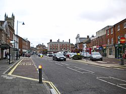
It is a tourist and farming town situated about 32 km (20 mi) northeast of Le Havre, at the junction of the D 940, D 11 and D 139 roads. It is located on...
12 KB (1,119 words) - 13:25, 1 March 2025

the 16th century. Two of France's best navigators, Michel le Vasseur and his brother Thomas le Vasseur, lived in Dieppe when they were recruited to join...
33 KB (3,049 words) - 00:45, 13 May 2025

Bois-Guillaume Boos Buchy Caudebec-en-Caux Caudebec-lès-Elbeuf Clères Darnétal Doudeville Duclair Elbeuf Grand-Couronne Le Grand-Quevilly Maromme Mont-Saint-Aignan...
14 KB (972 words) - 15:30, 12 April 2025
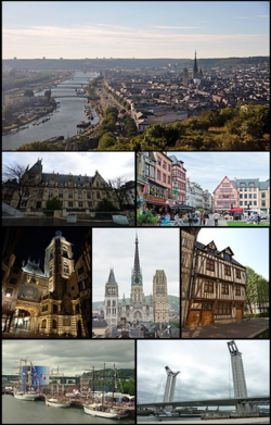
the largest of these suburbs are Sotteville-lès-Rouen, Saint-Étienne-du-Rouvray, Le Grand-Quevilly, Le Petit-Quevilly, and Mont-Saint-Aignan, each with...
42 KB (3,878 words) - 15:21, 26 June 2025

Communes of the Seine-Maritime department "Répertoire national des élus: les maires". data.gouv.fr, Plateforme ouverte des données publiques françaises...
4 KB (322 words) - 11:17, 21 August 2024
Carville-la-Folletière Carville-Pot-de-Fer Le Catelier Catenay Caudebec-lès-Elbeuf Le Caule-Sainte-Beuve Cauville-sur-Mer Les Cent-Acres La Cerlangue La Chapelle-du-Bourgay...
2 KB (111 words) - 11:02, 30 August 2022

Communes of the Seine-Maritime department "Répertoire national des élus: les maires". data.gouv.fr, Plateforme ouverte des données publiques françaises...
2 KB (113 words) - 10:36, 6 April 2023
Communes of the Seine-Maritime department "Répertoire national des élus: les maires" (in French). data.gouv.fr, Plateforme ouverte des données publiques...
2 KB (78 words) - 14:50, 25 August 2024
1948), canoeist, competed in the 1968 Summer Olympics Melle, Germany Caudebec-lès-Elbeuf, France Ciechocinek, Poland Encs, Hungary Graduation tower Spa gardens...
11 KB (1,069 words) - 15:07, 14 November 2024
Communes of the Seine-Maritime department "Répertoire national des élus: les maires". data.gouv.fr, Plateforme ouverte des données publiques françaises...
2 KB (117 words) - 12:51, 25 August 2024

Carville-la-Folletière Carville-Pot-de-Fer Le Catelier Catenay Caudebec-lès-Elbeuf Le Caule-Sainte-Beuve Cauville-sur-Mer Les Cent-Acres La Cerlangue La Chapelle-du-Bourgay...
2 KB (112 words) - 12:46, 25 August 2024
Carville-la-Folletière Carville-Pot-de-Fer Le Catelier Catenay Caudebec-lès-Elbeuf Le Caule-Sainte-Beuve Cauville-sur-Mer Les Cent-Acres La Cerlangue La Chapelle-du-Bourgay...
2 KB (117 words) - 12:45, 25 August 2024
Carville-la-Folletière Carville-Pot-de-Fer Le Catelier Catenay Caudebec-lès-Elbeuf Le Caule-Sainte-Beuve Cauville-sur-Mer Les Cent-Acres La Cerlangue La Chapelle-du-Bourgay...
2 KB (111 words) - 12:46, 30 August 2022

Saint-Pierre-lès-Elbeuf (French pronunciation: [sɛ̃ pjɛʁ lɛ.z‿ɛlbœf], literally Saint-Pierre near Elbeuf) is a commune in the Seine-Maritime department...
3 KB (178 words) - 14:51, 25 August 2024
Communes of the Seine-Maritime department "Répertoire national des élus: les maires". data.gouv.fr, Plateforme ouverte des données publiques françaises...
2 KB (118 words) - 14:50, 25 August 2024
Communes of the Seine-Maritime department "Répertoire national des élus: les maires" (in French). data.gouv.fr, Plateforme ouverte des données publiques...
2 KB (114 words) - 12:52, 25 August 2024
Carville-la-Folletière Carville-Pot-de-Fer Le Catelier Catenay Caudebec-lès-Elbeuf Le Caule-Sainte-Beuve Cauville-sur-Mer Les Cent-Acres La Cerlangue La Chapelle-du-Bourgay...
2 KB (98 words) - 15:04, 25 July 2022
Robertot (category Arrondissement of Le Havre geography stubs)
Durdent, in the Pays de Caux, approximately 31 miles (50 km) northeast of Le Havre, at the junction of the D53 and D106 roads. The church of St.Pierre...
2 KB (102 words) - 20:42, 30 March 2025

Carville-la-Folletière Carville-Pot-de-Fer Le Catelier Catenay Caudebec-lès-Elbeuf Le Caule-Sainte-Beuve Cauville-sur-Mer Les Cent-Acres La Cerlangue La Chapelle-du-Bourgay...
2 KB (113 words) - 11:18, 30 August 2022

Maniquerville (category Arrondissement of Le Havre geography stubs)
A farming village in the Pays de Caux, some 15 miles (24 km) northeast of Le Havre, at the junction of the D11 and D279 roads. The church of St.Martin...
2 KB (98 words) - 13:51, 5 October 2024