
The Central Elbe Table (Czech: Středolabská tabule) is a plateau and a geomorphological mesoregion of the Czech Republic. It is located mostly in the Central...
4 KB (431 words) - 17:59, 8 November 2024
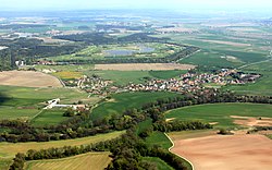
Pardubice and Central Bohemian region. The Elbe River flows through the territory, after which the plateau is named. The East Elbe Table is a mesoregion...
5 KB (456 words) - 09:13, 18 June 2025
municipal territory lies in a flat agricultural landscape in the Central Elbe Table. The western part lies in the Upper Sázava Hills and includes the...
30 KB (3,296 words) - 08:39, 16 May 2025
Prague (redirect from Central Prague)
extends into the Hořovice Uplands, in the north it extends into the Central Elbe Table lowland. The highest point is the top of the hill Teleček on the western...
157 KB (14,143 words) - 19:37, 3 July 2025

southwest of Pardubice. It lies in a flat agricultural landscape of the Central Elbe Table. The Brslenka Stream flows through the town and supplies several ponds...
11 KB (932 words) - 14:46, 19 May 2025
in the Central Elbe Table within the Polabí lowland. The town is situated on both banks of the Elbe River and lies at the confluence of the Elbe and Mrlina...
11 KB (986 words) - 18:25, 20 May 2025

municipality lies in the Prague Plateau, the eastern part lies in the Central Elbe Table. The settlement was first mentioned in 1233 as the possession of the...
8 KB (671 words) - 10:58, 26 May 2025
region, on the border between the East Elbe Table and Central Elbe Table. It lies on the right bank of the Elbe River. The soil is mainly clay, with loess...
8 KB (723 words) - 10:03, 4 June 2025

(14 mi) east of Prague. It lies in a flat agricultural landscape of the Central Elbe Table. The highest point is at 275 m (902 ft) above sea level. The Šembera...
11 KB (952 words) - 14:47, 19 May 2025
east of Prague. It lies in the Central Elbe Table, in the Polabí lowlands. The town is situated on the left bank of the Elbe River. The site of the town...
7 KB (404 words) - 09:50, 16 May 2025

Old Elbe Tunnel or St. Pauli Elbe Tunnel (German: Alter Elbtunnel colloquially or St. Pauli Elbtunnel officially), which opened in 1911, is a pedestrian...
7 KB (730 words) - 08:33, 13 June 2024

landscape in the Central Elbe Table. The municipality is situated at the confluence of the Elbe and Vltava rivers, on the left bank of the Elbe. The Vraňany–Hořín...
8 KB (549 words) - 12:25, 1 June 2025

39 km (24 mi) east of Prague. It lies in the Central Elbe Table lowland within the Polabí region. The Elbe River flows through the town. South of the town...
14 KB (1,293 words) - 19:27, 22 May 2025

territory lies in the Jizera Table, the eastern part lies in the Central Elbe Table. The Mlynařice stream, a tributary of the Elbe, flows through the territory...
12 KB (943 words) - 11:00, 16 May 2025

The Elbe Sandstone Mountains, also called the Elbe Sandstone Highlands (German: Elbsandsteingebirge, pronounced [ɛlpˈz̥antʃtaɪnɡəˌbɪʁɡə]; Czech: Děčinská...
20 KB (2,302 words) - 06:18, 8 June 2025

territory), Giant Mountains Foothills (northeast), East Elbe Table (south), Central Elbe Table (southwest) and Ještěd–Kozákov Ridge (small part in the...
12 KB (708 words) - 11:00, 19 May 2025

(19 mi) east of Prague. It lies in a flat agricultural landscape in the Central Elbe Table. The Výrovka River flows through the town. The astronomical centre...
10 KB (833 words) - 05:29, 23 May 2025
Mělník (category Populated places on the Elbe)
part of the municipal territory lies in the Central Elbe Table, the northeastern part lies in the Jizera Table. The highest point is the hill Chloumeček...
13 KB (1,291 words) - 18:13, 21 May 2025

(Rokytská horka) Central Elbe Table (Středolabská tabule) VIB-3 2,266 215.0 400 (a contour line) East Bohemian Table East Elbe Table (Východolabská tabule)...
17 KB (292 words) - 04:08, 24 July 2024
west of Pardubice. It lies in a flat agricultural landscape of the Central Elbe Table. The Brslenka Stream flows through the municipality. The first written...
5 KB (325 words) - 09:49, 3 June 2025

east of Nymburk and 54 km (34 mi) east of Prague. It lies in the Central Elbe Table. The highest point is a place called Kostelíček at 241 m (791 ft)...
7 KB (453 words) - 08:54, 22 May 2025

Svitavy Uplands (north), Central Elbe Table (a small part in the west), Upper Sázava Hills (a small part in the west) and East Elbe Table (a small part in the...
12 KB (686 words) - 11:06, 19 May 2025
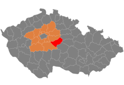
Kutná Hora District (category Districts of the Central Bohemian Region)
geomorphological mesoregions: Upper Sázava Hills (most of the territory), Central Elbe Table (north), Vlašim Uplands (small part in the southwest) and Iron Mountains...
12 KB (757 words) - 12:25, 16 May 2025

(5 mi) east of Prague. It lies in a flat agricultural landscape in the Central Elbe Table. The first written mention of Nehvizdy (regarding local parish) is...
7 KB (479 words) - 09:52, 16 May 2025

Jičín and 56 km (35 mi) northeast of Prague. It lies mostly in the Central Elbe Table. The northernmost part of the municipal territory belongs to the Jičín...
7 KB (455 words) - 05:28, 16 June 2025

north of Prague. It lies on the border between the Prague Plateau and Central Elbe Table. The first written mention of Odolena Voda is from 1352. Until the...
6 KB (421 words) - 09:51, 16 May 2025

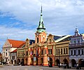
of Kutná Hora and 32 km (20 mi) west of Pardubice. It lies in the Central Elbe Table lowland. The market town is situated on the right bank of the Klejnárka...
8 KB (566 words) - 05:27, 21 May 2025
Kolín (category Populated places on the Elbe)
(29 mi) east of Prague. It lies in a fertile landscape of the Central Elbe Table lowland. The Elbe River flows through the town. In the eastern part of the...
15 KB (1,381 words) - 06:25, 27 June 2025

geomorphological mesoregions: East Elbe Table (most of the territory), Orlice Table (east) and Central Elbe Table (small part in the southwest). The highest...
13 KB (665 words) - 10:15, 19 May 2025

(25 mi) east of Prague. It lies in a flat agricultural landscape in the Central Elbe Table. The first written mention of Velim is in a deed of King John of Bohemia...
6 KB (421 words) - 05:28, 23 May 2025