
The Cerro El Veladero is a mountain in the state of Guerrero to the north of Acapulco. The Cerro El Veladero is southwest of El Veladero (Veladero Morelos)...
3 KB (157 words) - 21:14, 30 December 2021

The Battle of El Veladero was a battle of the War of Mexican Independence that occurred from 1810 to 30 April 1811 at Cerro El Veladero, Acapulco de Juárez...
4 KB (324 words) - 14:42, 4 April 2024
6,658 m (21,844 ft) El Muerto 6,488 m (21,286 ft) Cerro Nacimiento 6,436 m (21,115 ft) Cerro Veladero 6,436 m (21,115 ft) Cerro El Cóndor (also Volcán...
3 KB (359 words) - 22:34, 10 June 2024

porters, and started a women's battalion. They found Morelos in the Cerro El Veladero mountains above Acapulco. Morelos had received orders from Miguel...
12 KB (1,566 words) - 20:20, 12 June 2024
region, forming the high volcanic edifices Monte Pissis, Cerro Bonete Chico and Sierra de Veladero. Later, a number of lava domes were emplaced between these...
35 KB (3,976 words) - 06:07, 14 June 2024
Distrito Federal (Ciudad de México) El Tepozteco National Park 1937 232 Morelos; Distrito Federal (Ciudad de México) El Veladero National Park 1980 36 Guerrero...
7 KB (131 words) - 08:10, 30 March 2024
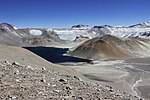
Viviana; Morrill, Jan (December 2, 2022). "Water contamination at Barrick's Veladero mine threatens health and human rights". MiningWatch Canada. Retrieved...
20 KB (2,395 words) - 12:08, 11 June 2024
List of mountains in the Andes (redirect from Cerro Cesius)
one hundred 6000m peaks in the Andes and nearly 900 peaks over 5000 m. "Cerro Amaculla (CHL) Feature -872055". geonames.nga.mil. Retrieved 25 September...
61 KB (174 words) - 21:34, 18 April 2024
del Carmen Dzibilchantun El Cimatario El Gogorrón El Histórico Coyoacán El Potosí El Sabinal El Tepeyac El Tepozteco El Veladero Fuentes Brotantes de Tlalpan...
3 KB (121 words) - 01:43, 28 March 2024
que crea el distrito de Almirante, y los corregimientos Barrio Francés, Barriada Guaymí, Barriada 4 de Abril, Finca 30, Finca 6, Finca 60 y El Silencio...
31 KB (135 words) - 12:20, 30 April 2024
Tierras Altas District had been approved, consisting of the corregimientos of Cerro Punta, Cuesta de Piedra, Nueva California, Paso Ancho and Volcán, which...
14 KB (647 words) - 03:22, 17 March 2024

Túpac Amaru: el rey que Argentina pudo tener". 13 July 2016. Archived from the original on 23 September 2023. Retrieved 25 June 2021. "El 'plan del Inca'...
249 KB (23,528 words) - 08:24, 24 June 2024

corregimientos: Tolé (capital) Cerro Viejo Lajas de Tolé Potrero de Caña Quebrada de Piedra Bella Vista El Cristo Justo Fidel Palacios Veladero "Districts of Panama"...
4 KB (78 words) - 14:12, 11 November 2021
El Potosí National Park is a protected area in northwestern Mexico. It is located in San Luis Potosí.It has an area of 20 km2. The park was established...
4 KB (402 words) - 20:20, 22 July 2023
Campichuelo 19 Dec Revolutionary Argentinian forces defeats Spanish Royalist troops. Mexican War of Independence Battle of El Veladero Mexicans defeat Spanish...
246 KB (77 words) - 08:56, 19 June 2024
en Santa Cruz el Rincón, comunidad me'phaa de Malinaltepec, Guerrero (MSc thesis). ENAH. pp. 39–64. Retrieved 28 November 2023. "Cerro Ardilla". PeakVisor...
12 KB (962 words) - 15:14, 7 February 2024
Tronconal Puebla 244 Atzitzintla Puebla 245 Ciudad Serdán Puebla 245 El Veladero (Santa Cruz Velader) Puebla 245 Esperanza Puebla 245 San Juan Atenco...
30 KB (48 words) - 18:42, 31 May 2024

phase (1810–1815) Battle of El Veladero (1810–1811) Battle of Puerto de Piñones (1811) Battle of Zacatecas (1811) Battle of El Maguey (1811) Battle of Llanos...
41 KB (2,975 words) - 06:30, 19 June 2024
War of Independence (Spanish American wars of independence) Battle of El Veladero – 1810 – 1811 – Mexican War of Independence (Spanish American wars of...
453 KB (52,456 words) - 06:50, 24 June 2024
The Sierra de Ocotlán (or Cerro Frío) is on the southern border; its main heights are: Cerro del Veladero, el Sombrerito, and el Picacho at 1,250 meters...
26 KB (2,698 words) - 08:18, 14 April 2024

hill and mountains within a few kilometers of the southeast are called the Cerros Nevados. The Pascua ore body is located in the Nevada mineral zone or Nevada...
23 KB (2,800 words) - 17:54, 5 September 2023
Atucha Embalse Yacyretá Salto Grande Piedra del Aguila El Chocón Alicurá Futaleufú Planicie Banderita San Nicolás Dock Sud Map all coordinates using OpenStreetMap...
20 KB (244 words) - 22:25, 8 May 2024