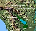
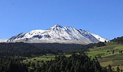
Laguna Salada Yuma Gulf of California Colorado River Valley Cerro Prieto volcano Cerro Prieto (Cocopah: Wee Ñaay, lit. 'Dark Hill') is a volcano located...
4 KB (219 words) - 20:31, 24 May 2025
Cerro Prieto is a small rural town located in the county of La Misión in the northwestern part of the Mexican state of Hidalgo. The geography of Cerro...
1 KB (224 words) - 21:14, 16 December 2018
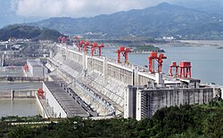
The Cerro Prieto Geothermal Power Station is a complex of geothermal power stations in Baja California, Mexico. It is the world's largest complex of geothermal...
6 KB (501 words) - 22:21, 10 December 2024
Valley Cerro Prieto volcano The Cerro Prieto Fault is a transform fault located in far northern Baja California. It runs between the Cerro Prieto spreading...
4 KB (188 words) - 19:36, 24 November 2024
Cerro Potosí, highest mountain in the Sierra Madre Oriental, Nuevo León Cerro Prieto, Baja California Cerro Prieto, small rural town, Hidalgo Cerro Prieto...
23 KB (2,785 words) - 09:26, 12 April 2025
Ranges between the Laguna Salada basin to the west and the Cerro Prieto Volcano and Cerro Prieto Geothermal Power Station to the east. The geothermal field...
2 KB (153 words) - 01:31, 28 March 2022

squash and other crops in Mexicali. The nearby Cerro Prieto volcano is adjacent to the Cerro Prieto Geothermal Power Station, which creates high volumes...
46 KB (4,260 words) - 10:57, 8 April 2025
sources during the Wisconsin glaciation. The lake overflowed close to Cerro Prieto into the Rio Hardy, eventually draining into the Gulf of California....
78 KB (9,584 words) - 14:54, 18 February 2025

River mouth Laguna Salada Yuma Gulf of California Colorado River Valley Cerro Prieto volcano The southern segment (also known as the Mojave segment) begins...
43 KB (4,443 words) - 02:33, 25 May 2025
River mouth Laguna Salada Yuma Gulf of California Colorado River Valley Cerro Prieto volcano The Imperial Fault Zone is a system of geological faults located...
6 KB (397 words) - 19:02, 13 January 2024

The New River (Spanish: Río Nuevo) flows north from near Cerro Prieto, through the city of Mexicali, Baja California, Mexico, into the United States through...
21 KB (2,298 words) - 10:44, 8 May 2025
River mouth Laguna Salada Yuma Gulf of California Colorado River Valley Cerro Prieto volcano The Salton Buttes lie on the southeastern shores of the Salton...
35 KB (3,689 words) - 08:20, 28 April 2025
April 2014. Powerhouses of Cerro Prieto, archived from the original on 19 April 2010, retrieved 20 March 2010 Cerro Prieto Geothermal Power Station, archived...
157 KB (5,457 words) - 06:25, 23 April 2025

River mouth Laguna Salada Yuma Gulf of California Colorado River Valley Cerro Prieto volcano Imperial Valley has become a "hot-bed" of renewable energy projects...
45 KB (4,502 words) - 09:41, 14 May 2025
River mouth Laguna Salada Yuma Gulf of California Colorado River Valley Cerro Prieto volcano The Brawley Seismic Zone (BSZ), also known as the Brawley fault...
10 KB (842 words) - 19:13, 24 November 2024

in others limited to six hours a day. The city has three reservoirs. Cerro Prieto Reservoir dropped to 1% of its capacity and La Boca Reservoir dropped...
102 KB (9,690 words) - 04:12, 2 June 2025

peninsula to the Pacific plate. From north to south: Imperial Fault Zone Cerro Prieto Fault Ballenas Fault Partida Fault San Lorenzo Fault Guaymas Fault Carmen...
2 KB (208 words) - 04:39, 6 December 2024

Colorado River, this area has become a true agricultural center. The Cerro Prieto geothermal province is near Mexicali as well (this area is geologically...
68 KB (5,764 words) - 09:01, 4 May 2025

stratovolcano Pinacate, volcanic field Popocatepetl, stratovolcano Cerro Prieto, lava dome San Borja Volcanic Field Isla San Luis, tuff cone San Martin...
27 KB (2,488 words) - 03:44, 3 June 2025
about 30 feet above sea level, and at that point overflow its banks near Cerro Prieto, and run south to the Gulf of California; during those times, the Rio...
6 KB (499 words) - 08:36, 10 December 2024

set foot and explore west of the Colorado River, reaching mudpots near Cerro Prieto, and in the Imperial Valley. During his Colorado River exploration Díaz...
8 KB (868 words) - 21:37, 29 May 2025
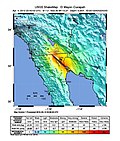
after the nearby town of El Indiviso. A liquefaction zone bounded by the Cerro Prieto Fault and the Laguna Salada Fault was observed. Mexicali, El Centro,...
35 KB (3,189 words) - 05:47, 9 May 2025
with the East Pacific Rise and is located near the southern end of the Cerro Prieto fault. The depression is a result of subsidence caused by the extensional...
2 KB (229 words) - 01:11, 12 November 2024

River mouth Laguna Salada Yuma Gulf of California Colorado River Valley Cerro Prieto volcano Parts of Imperial Valley lie atop the Salton Sea Geothermal Field...
13 KB (594 words) - 19:41, 1 April 2025
been found highly deteriorated ceramic pieces. On the west side is the Cerro Prieto Cave, which is really a rock shelter which is more than 60 meters high...
15 KB (1,378 words) - 21:29, 9 February 2025
years. As of 2005, the municipality had a total population of 10,096. Cerro Prieto, Hidalgo "La Misión". Enciclopedia de los Municipios de México. Instituto...
5 KB (113 words) - 20:59, 18 November 2021

today. The southernmost extension of the San Andreas fault system, the Cerro Prieto Fault, passes directly through the area before continuing offshore into...
19 KB (2,657 words) - 15:03, 31 October 2024
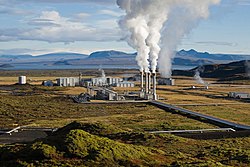
well for reheating/reuse. As of 2013, the largest liquid system was Cerro Prieto in Mexico, which generates 750 MW of electricity from temperatures reaching...
57 KB (5,447 words) - 05:16, 5 June 2025

Retrieved 2021-10-12. "Cerro Roncador". peakery.com. Retrieved 2021-10-12. "Cerro Prieto". peakery.com. Retrieved 2021-10-12. "Cerro El Malo". peakery.com...
49 KB (3,371 words) - 10:49, 26 October 2024

adjacent islands include: Volcanoes of east-central Baja California Cerro Prieto The San Quintín Volcanic Field Isla San Luis Jaraguay volcanic field...
32 KB (3,874 words) - 00:50, 3 June 2025