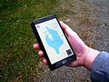
Collaborative mapping, also known as citizen mapping, is the aggregation of Web mapping and user-generated content, from a group of individuals or entities...
16 KB (2,034 words) - 05:18, 20 April 2025
OpenGeofiction (abbreviated OGF) is an online collaborative mapping project focused on fantasy cartography and worldbuilding of a world analogous to Earth...
7 KB (545 words) - 09:07, 28 May 2025
(also spelled Open Historical Map and abbreviated OHM) is an online collaborative mapping project developing a historical map of the world using OpenStreetMap...
21 KB (1,984 words) - 18:47, 16 July 2025

History of cartography (redirect from Dutch mapping of Nova Hollandia)
and History of web mapping. Aerial photography and satellite imagery have provided high-accuracy, high-throughput methods for mapping physical features...
143 KB (17,654 words) - 23:22, 23 June 2025

OpenRailwayMap (category Collaborative mapping)
OpenRailwayMap (ORM) is an online collaborative mapping project developing a worldwide railway map using technology based on the OpenStreetMap project...
6 KB (487 words) - 20:53, 7 April 2025
events worldwide. Collaborative maps are a developing potential. In proprietary or open source collaborative software, users collaborate to create and improve...
40 KB (4,674 words) - 23:52, 30 July 2025
They are best known as the creator of the community-based online collaborative mapping platform Queering the Map. LaRochelle grew up in Ontario. In 2016...
7 KB (578 words) - 16:28, 27 May 2025
Build the Earth (category Collaborative mapping)
BuildTheEarth was created by YouTuber PippenFTS in March 2020 as a collaborative effort to recreate Earth in the video game Minecraft. During the COVID-19...
8 KB (661 words) - 14:43, 28 July 2025
Queering the Map (category Collaborative mapping)
Queering the Map is a community-based online collaborative and counter-mapping platform on which users submit their personal queer experiences to specific...
13 KB (1,171 words) - 12:56, 19 July 2025
Human Wasteland (category Collaborative mapping)
(Human) Wasteland was a map based visualization project created by software engineer Jennifer Wong. The map visualized reports of human waste reported...
3 KB (247 words) - 17:04, 23 December 2024
Concept mapping and mind mapping software is used to create diagrams of relationships between concepts, ideas, or other pieces of information. It has been...
13 KB (206 words) - 09:24, 21 May 2025
Wikiloc (category Collaborative mapping)
Chinese, Spanish and Turkish Created by Jordi L. Ramot & voluntary collaborators URL www.wikiloc.com Commercial Yes Registration Optional (required to...
11 KB (761 words) - 08:29, 11 July 2025

Wikimapia (category Collaborative mapping)
25, 2022. According to the website, Wikimapia is an open-content collaborative mapping project, aimed at marking all geographical objects in the world...
15 KB (1,508 words) - 17:57, 20 May 2025
A mapathon (sometime written map-a-thon) is a coordinated mapping event and a kind of editathon. The public is invited to make online map improvements...
7 KB (737 words) - 05:41, 11 May 2025
aspects of geography that are out of scope for OSM. Collaborative mapping – Aggregation of web mapping and user content Neogeography – Amateur-focused geography...
111 KB (10,665 words) - 04:45, 1 August 2025

SeeClickFix (category Collaborative mapping)
SeeClickFix is a digital communications system company founded and based in downtown New Haven, Connecticut. The company runs a website and app which assist...
6 KB (408 words) - 21:45, 19 June 2025

GeoNames (category Collaborative mapping)
GeoNames (or GeoNames.org) is a user-editable geographical database available and accessible through various web services, under a Creative Commons attribution...
6 KB (580 words) - 23:16, 19 May 2025

AllTrails (category Collaborative mapping)
partnership contributed to an increase in the app's user base and enhanced its mapping data. This partnership also resulted in National Geographic's Topo.com...
10 KB (811 words) - 19:30, 5 May 2025
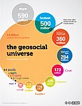
Geosocial networking (category Collaborative mapping)
individual perspectives. This type of geosocial networking is known as collaborative mapping. Furthermore, geolocated messages could assist automated tools to...
14 KB (1,535 words) - 16:40, 24 May 2025
Geo-Wiki (category Collaborative mapping)
Reithmaier, Lucia; Strobl, Peter (2009). "Pan-European forest/Non-forest mapping with Landsat ETM+ and CORINE Land Cover 2000 data". ISPRS Journal of Photogrammetry...
8 KB (790 words) - 15:32, 8 November 2024

GADM (category Collaborative mapping)
Free Geography Tools website Kelly Center blog chloropleth map of deforestation in Africa Swiss canton languages Marine Life Mapping & Visualisation...
3 KB (179 words) - 16:29, 23 March 2023
Miro (collaboration platform) (category Mind-mapping software)
Miro is a collaborative online platform designed to support teams in planning, and execution across different locations and time zones. It is used for...
8 KB (690 words) - 18:02, 12 July 2025
Participatory GIS (category Collaborative mapping)
towards web-based mapping services to further simplify and extend the process into the community. Collaborative mapping Counter-mapping Geodesign Geographic...
27 KB (3,317 words) - 07:05, 20 May 2025
Ramani Huria (category Collaborative mapping)
Ramani Huria is community-based mapping project in Dar Es Salaam, Tanzania, training university students and local community members to create highly...
7 KB (699 words) - 16:56, 1 August 2025

(Karnataka). In 2016 a collaborative mapping project, Stepwell Atlas, started to map GPS coordinates and collate information on stepwells, mapping over 2800 stepwells...
19 KB (2,152 words) - 19:23, 28 July 2025

Collaborative filtering (CF) is, besides content-based filtering, one of two major techniques used by recommender systems. Collaborative filtering has...
39 KB (4,799 words) - 02:34, 17 July 2025

The National Map (category Collaborative mapping)
The National Map is a collaborative effort of the United States Geological Survey (USGS) and other federal, state, and local agencies to improve and deliver...
8 KB (719 words) - 00:44, 8 April 2025
This is a list of causal mapping software. Causal mapping software enables users to create and/or work with causal maps: qualitative networks of interconnected...
7 KB (159 words) - 11:07, 20 February 2024
Crowdmapping (redirect from Crowdsourced mapping)
earthquake 3D reconstruction from multiple images Sensor journalism Crisis mapping Mass collaboration Big data Data activism Artificial Intelligence for Digital...
12 KB (1,023 words) - 04:25, 10 June 2025
MapWith.Us (category Web mapping)
select audience, or without restriction. MapWith.Us makes every map a collaborative map by default, with per-user data segmentation accomplished via overlays...
5 KB (579 words) - 02:27, 7 April 2025