
The Crouch and Roach Estuaries are a 1729 hectare biological Site of Special Scientific Interest (SSSI) at the mouth of the Crouch and Roach rivers in...
5 KB (408 words) - 03:38, 14 August 2024

Crouch, Roach and Colne Estuaries is a Marine Conservation Zone (MCZ), located in Essex, England. It includes the Blackwater, Colne, Crouch and Roach...
6 KB (632 words) - 16:22, 13 February 2025
centred on Rochford and the River Crouch and Roach estuaries. It is waymarked, and named on Ordnance Survey mapping. The Roach Valley Way was devised around...
3 KB (290 words) - 05:46, 7 April 2025

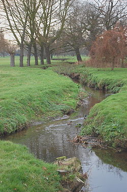
of the Crouch and Roach Estuaries Site of Special Scientific Interest. The site lies between two tidal creeks which run into the River Crouch. It has...
2 KB (168 words) - 03:35, 14 August 2024

biological SSSI, Crouch and Roach Estuaries. It is a Geological Conservation Review site both for its fossil birds and for its fishes and amphibians. Fossils...
3 KB (238 words) - 03:05, 22 July 2024

from the original on 1 June 2016. Retrieved 19 May 2016. "Map of Crouch and Roach Estuaries". Sites of Special Scientific Interest. Natural England. Archived...
151 KB (4,858 words) - 13:36, 23 August 2024
Impact Structures. Imperial College Press. ISBN 978-1-86094-356-0. "Crouch & Roach Estuaries". Ramsar Sites Information Service. Retrieved 25 April 2018. Stratford...
29 KB (3,558 words) - 17:29, 26 June 2024

Lion Creek and Lower Raypits is a 65.2-hectare (161-acre) nature reserve east of Canewdon in Essex. It is part of the Crouch and Roach Estuaries Site of...
2 KB (225 words) - 03:37, 14 August 2024
Estuary Crouch-Roach Estuary Cuckmere Estuary Dart Estuary Deben Estuary Dee Estuary Dengie Flats Duddon Estuary Eastern Yar Erme Estuary Esk Estuary...
2 KB (221 words) - 14:53, 1 November 2023

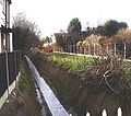
the Crouch and Roach Estuaries Site of Special Scientific Interest. This site has been grassland for the last 100 years, and it is grazed by cows and sheep...
2 KB (239 words) - 03:37, 14 August 2024
and for the cultivation of shellfish, mainly Native Oysters ostrea edulis which were abundant in the area. It is part of the Crouch and Roach Estuary...
2 KB (277 words) - 19:17, 13 May 2025

from the original on 1 June 2016. Retrieved 19 May 2016. "Map of Crouch and Roach Estuaries". Sites of Special Scientific Interest. Natural England. Archived...
89 KB (2,950 words) - 01:21, 18 November 2024

Woodham Ferrers Bridgemarsh Island Wallasea Island Foulness Island "Crouch & Roach Estuaries". Ramsar Sites Information Service. Retrieved 25 April 2018. King...
29 KB (3,577 words) - 19:28, 11 May 2025

intersects at Leigh-on-Sea; Roach Valley Way (a 23-mile (37 km) circular walk around Rochford and the Crouch and Roach estuaries) intersects at Hockley. "The...
5 KB (514 words) - 04:47, 26 February 2024

off the defences and main watercourses. There are many smaller estuaries in Essex, including the rivers Colne, Blackwater and Crouch. Small coastal villages...
30 KB (2,658 words) - 12:27, 18 March 2025

bounded to the north by the River Crouch, to the south east by the River Roach, and to the west by Paglesham Pool and the narrow Paglesham Creek. The population...
8 KB (953 words) - 15:57, 8 January 2025
SU761014 Colne Estuary (Mid-Essex Coast Phase 2) Essex UK9009243 TM040172 Coquet Island Northumberland UK9006031 NU294047 Crouch and Roach Estuaries (Mid-Essex...
29 KB (47 words) - 14:05, 5 December 2024
discharges into the Roach and then into the North Sea via the Roach and Crouch estuaries. Prittle Brook rises in Thundersley near Kiln Road opposite Shipwrights...
9 KB (979 words) - 03:08, 3 May 2025
Southend-on-Sea and the Crouch estuary in Essex. It is a key site in A Nature Conservation Review, and is part of the Essex Estuaries Special Area of...
4 KB (277 words) - 03:40, 14 August 2024
immigration detention center in Pennsylvania Blackwater, Crouch, Roach and Colne Estuaries Marine Conservation Zone (BCRC MCZ), Essex, England British...
812 bytes (140 words) - 13:31, 27 October 2024
Cambridgeshire 1.12 11 March 1992 Colne Estuary (Mid-Essex Coast Phase 2) Essex Coast 27.01 28 July 1994 Crouch and Roach Estuaries (Mid-Essex Coast Phase 3) Essex...
10 KB (103 words) - 22:04, 14 April 2025
located on low-lying land close to marshes, estuaries and tidal bays, with rivers such as the Crouch and Roach, which have low freshwater outflows, having...
15 KB (2,158 words) - 21:05, 26 January 2024

conservation zone 2013 designation: Blackwater, Crouch, Roach and Colne Estuaries". Department for Environment, Food and Rural Affairs. 21 November 2013. Retrieved...
5 KB (494 words) - 21:15, 25 February 2025

115 hectares (1.15 km2) and is sited on Wallasea Island, which borders two rivers (River Crouch to the north and River Roach to the south-east). They...
6 KB (765 words) - 00:04, 6 June 2022

District Council. The Roach Valley Way is a 23-mile (37 km) circular path centred on Rochford and the River Crouch and River Roach estuaries. Rochford Hundred...
17 KB (1,680 words) - 11:54, 2 June 2025
List of rivers discharging into the North Sea (section Flowing into the North Sea – North of the Thames Estuary)
Ray River Key River Churn From Shoeburyness to St Abb's Head River Crouch River Roach Prittle Brook River Blackwater River Chelmer River Ter River Brain...
37 KB (2,533 words) - 20:56, 21 May 2025
Drainage District Lower Crouch and Roach Drainage District Maldon, Wivenhoe and Clacton Internal Drainage District Mundon and Latchingdon Internal Drainage...
13 KB (1,489 words) - 00:32, 21 September 2024

The Broomway (section Navigation and access)
floods across the sands at high speed and the water forms whirlpools from flows of the River Crouch and River Roach. Under such conditions, the direction...
15 KB (1,889 words) - 20:38, 13 April 2025

Axe Estuary Beachy Head East Bembridge Berwick to St. Mary's Camel Estuary Cape Bank Dart Estuary Devon Avon Estuary East of Start Point Erme Estuary Foreland...
14 KB (1,024 words) - 07:44, 7 June 2024

HMS Beagle (section Design and construction)
Thames Estuary. She was moored mid-river in the River Roach which forms part of an extensive maze of waterways and marshes known as The River Crouch and River...
35 KB (3,933 words) - 22:34, 23 May 2025