
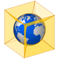
A discrete global grid (DGG) is a mosaic that covers the entire Earth's surface. Mathematically it is a space partitioning: it consists of a set of non-empty...
43 KB (3,199 words) - 03:26, 5 May 2025
The Military Grid Reference System (MGRS) is the geocoordinate standard used by NATO militaries for locating points on Earth. The MGRS is derived from...
15 KB (2,136 words) - 19:17, 1 June 2025
Geocode (section Name-and-grid systems)
BR-AM for Amazonas state). DGG cell ID. Identifier of a cell of a discrete global grid: a Geohash code (e.g. ~0.023 km2 cell 6vd23gq at Brazil's centroid)...
36 KB (3,233 words) - 02:31, 6 June 2025

valid discrete global grid. Primarily, the cells' area and shape are generally similar, especially near the poles where many other spatial grids have singularities...
12 KB (1,347 words) - 16:38, 16 April 2025
Page - Grid indices for astronomy Grid Traversal implementation details and applet demonstration PYXIS Discrete Global Grid System using the ISEA3H Grid...
7 KB (903 words) - 20:59, 15 October 2023
Ordnance Survey National Grid reference system (OSGB), also known as British National Grid (BNG), is a system of geographic grid references, distinct from...
19 KB (2,175 words) - 10:16, 2 May 2025

Digital elevation model (section Global)
objects, commonly of a planet, moon, or asteroid. A "global DEM" refers to a discrete global grid. DEMs are used often in geographic information systems...
32 KB (3,352 words) - 06:36, 9 June 2025

Projected coordinate system (redirect from Grid references)
Bermuda National Grid Hellenic Geodetic Reference System 1987 (Greece) Israeli Transverse Mercator (NIG) Swedish grid (RT90) Discrete global grid (DGG) East...
21 KB (2,805 words) - 00:44, 11 June 2025
The Irish grid reference system is a system of geographic grid references used for paper mapping in Ireland (both Northern Ireland and the Republic of...
7 KB (754 words) - 22:01, 25 March 2025
sphere for short, is an equal-area polyhedral map projection and discrete global grid scheme for data collected on a spherical surface (either that of...
7 KB (822 words) - 20:59, 7 June 2025
{\displaystyle Comp(n,r)\leq r^{n}+1} Binary space partitioning Discrete global grid Polygon partition Tessellation Tomas Nikodym (2010). "Ray Tracing...
6 KB (1,001 words) - 10:32, 3 December 2024

graphics, a heightmap or heightfield is a raster image used mainly as Discrete Global Grid in secondary elevation modeling. Each pixel stores values, such as...
6 KB (624 words) - 12:16, 4 April 2024

entirely of triangular facets (a triangle mesh), used mainly as Discrete Global Grid in primary elevation modeling. The vertices of these triangles are...
5 KB (620 words) - 22:45, 20 March 2024
The Global Positioning System (GPS) is a satellite-based hyperbolic navigation system owned by the United States Space Force and operated by Mission Delta...
184 KB (19,110 words) - 08:39, 20 June 2025
of mesh#Classification of grids, in computational solutions of partial differential equations Lattice graph honeycomb (geometry) discrete global grid...
10 KB (1,430 words) - 17:24, 2 March 2025
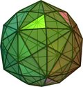
figure, it has been studied for its potential use in constructing discrete global grid systems for satellite imaging. It is topologically related to a polyhedra...
15 KB (1,361 words) - 12:10, 26 April 2025
projection Grid (spatial index), a discretization of a geometric domain into a set of contiguous cells, used to organize information Discrete global grid (DGG)...
4 KB (628 words) - 13:24, 8 December 2024
of Discrete Global Grid Systems". ISPRS International Journal of Geo-Information. 4 (1): 320–336. doi:10.3390/ijgi4010320. OGC Discrete Global Grid System...
28 KB (3,071 words) - 09:00, 6 June 2025

Geographic coordinate system (redirect from Global Coordinated System)
surface of Earth, without consideration of altitude or depth. The visual grid on a map formed by lines of latitude and longitude is known as a graticule...
23 KB (2,540 words) - 22:18, 14 May 2025

useful for creating discrete global grids, as with the quadrilateralized spherical cube and Icosahedral Snyder Equal Area (ISEA) grids. The earliest known...
9 KB (964 words) - 09:50, 24 June 2025
C-squares (section The c-squares global grid notation)
earth, represented as cells from a latitude- and longitude-based Discrete Global Grid at a hierarchical set of resolution steps, obtained by progressively...
48 KB (6,096 words) - 06:31, 13 June 2025

Polar Stereographic (UTM/UPS) coordinate system, which is a global (or universal) system of grid-based maps. The transverse Mercator projection is a variant...
18 KB (2,858 words) - 13:14, 29 May 2025
The United States National Grid (USNG) is a multi-purpose location system of grid references used in the United States. It provides a nationally consistent...
54 KB (6,263 words) - 07:04, 3 June 2025

objects, commonly of a planet, moon, or asteroid. A "global DEM" refers to a discrete global grid. DEMs are used often in geographic information systems...
14 KB (1,586 words) - 00:01, 24 May 2025
Galileo (Europe) NAVIC (India) Quasi-Zenith Sat. Sys. (QZSS) (Japan) Discrete Global Grid and Geocoding Standards (history) International Terrestrial Reference...
21 KB (2,443 words) - 15:24, 12 June 2025
following table: Examples of systems around the world are: Chinese Global Navigation Grid Code, China Israeli Cassini Soldner, Israel Israeli Transverse Mercator...
15 KB (1,570 words) - 12:19, 7 May 2025

Earth-centered, Earth-fixed coordinate system (category Global Positioning System)
system to actual locations on the Earth. The ECEF that is used for the Global Positioning System (GPS) is the geocentric WGS 84, which currently includes...
9 KB (912 words) - 16:39, 14 December 2024

map projection used in the ISEA (Icosahedral Snyder Equal Area) discrete global grids. It is named for John P. Snyder, who developed the projection in...
3 KB (266 words) - 18:03, 4 August 2024
for geophysics Deutsche Grammophon Gesellschaft, a record label Discrete Global Grid Dutch Game Garden an organization with the aim of promoting and improving...
648 bytes (115 words) - 21:39, 2 December 2024
World Geodetic System (category Global Positioning System)
between various stations, and differences in elevation, all reduced to a grid of latitudes, longitudes, and elevations. Heritage surveying methods found...
24 KB (2,842 words) - 03:41, 26 April 2025