El Segundo Boulevard is a west-east thoroughfare in Los Angeles County. It has a total length of 11.9 miles (19.2 km). At one time, it was named Ballona...
3 KB (278 words) - 04:27, 6 November 2024

that runs from the Sunset Strip in West Hollywood in the north to El Segundo Boulevard in Hawthorne in the south. It was named for Rancho Las Cienegas,...
12 KB (638 words) - 05:16, 14 April 2025
butterfly El Segundo High School El Segundo Unified School District El Segundo (LACMTA station) El Segundo Boulevard El Segundo Freeway, name for Interstate...
374 bytes (79 words) - 17:39, 7 May 2020

Camino Real" (Map). Google Maps. Retrieved August 7, 2021. "El Segundo renames Sepulveda Boulevard". abc7.com. June 6, 2018. Retrieved March 26, 2021. "Driving...
22 KB (1,627 words) - 02:54, 29 April 2025

Figueroa Street (redirect from Kobe Bryant Boulevard)
more than 30 miles (48 km) from its southern terminus at Harry Bridges Boulevard in the Wilmington neighborhood to Chevy Chase Drive in the city of La...
25 KB (1,943 words) - 14:46, 31 May 2025
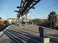
El Segundo station is an elevated light rail station on the K Line of the Los Angeles Metro Rail system. It is located over El Segundo Boulevard, after...
7 KB (572 words) - 23:24, 16 May 2025

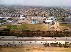
El Segundo (/ˌɛl səˈɡʌndoʊ/ EL sə-GUN-doh, Spanish: [el seˈɣundo]; Spanish for 'The Second') is a city in Los Angeles County, California, United States...
56 KB (5,031 words) - 19:55, 3 May 2025

Hawthorne–El Segundo Line was an interurban railway route of the Pacific Electric Railway. It was built to transport oil from the Standard Oil Refinery in El Segundo...
11 KB (888 words) - 04:35, 22 February 2025

abandoned enclosed shopping mall along Hawthorne Boulevard between 120th Street and El Segundo Boulevard in Hawthorne, California. Since closing in 1999...
12 KB (1,043 words) - 21:55, 30 May 2025
intersection of Aviation Boulevard and Manhattan Beach Boulevard. Aviation Boulevard also intersects with Century Boulevard, El Segundo Boulevard, Imperial Highway...
4 KB (319 words) - 07:05, 2 June 2025

was south of the current remaining area of Playa del Rey and north of El Segundo and immediately west of the perimeter of Los Angeles International Airport...
9 KB (786 words) - 07:12, 31 May 2025
Athens are: 87th Street to the north, Vermont Avenue to the east, El Segundo Boulevard to the south, and approximately Western Avenue to Van Ness Avenue...
25 KB (2,039 words) - 20:05, 18 January 2025

earlier, Bonin and Munro encountered 18-year-old Steven Jay Wells on El Segundo Boulevard. Bonin and Munro enticed him into the van. According to the pair...
165 KB (17,970 words) - 19:25, 1 June 2025

Avenue, El Segundo Boulevard, and Imperial Highway. Major north–south streets include Aviation Boulevard, Inglewood Avenue, Hawthorne Boulevard, Prairie...
56 KB (4,172 words) - 00:00, 26 May 2025

"America's First Freeway: The Arroyo Seco Parkway, aka, the 110". Truck Trend. El Segundo, California: Extreme Venturs, LLC. Retrieved April 10, 2018. "The History...
39 KB (3,329 words) - 06:26, 28 May 2025

south of Imperial Highway between Aviation Boulevard and the San Diego Freeway(I-405) to El Segundo Boulevard. The CDP also includes the area east of the...
25 KB (2,128 words) - 16:14, 21 May 2025
larger Barriox13 faction. It was founded in the early 1970s near El Segundo Boulevard and San Pedro Street in South Los Angeles, California. Originally...
3 KB (385 words) - 04:29, 15 December 2024

Los Angeles Air Force Base (category El Segundo, California)
plant owned by the Navy, at the northwest corner of Aviation and El Segundo Boulevards, was transferred to the Air Force in October 1962. Another site...
12 KB (1,187 words) - 07:34, 31 March 2025

Bay communities of Torrance, Lawndale, Redondo Beach, Hawthorne, and El Segundo. The freeway then encounters I-105 on the southeastern corner of Los Angeles...
50 KB (3,524 words) - 19:34, 28 May 2025

51 liquor outlets within a two-mile radius of the intersection of El Segundo Boulevard and Vermont Avenue. In 1989, however, Harbor Gateway was tied with...
26 KB (2,659 words) - 19:37, 7 May 2025

south of the intersection with Artesia Boulevard/western end of the Gardena Freeway (SR 91), and El Segundo Boulevard, Vermont marks the eastern boundary...
9 KB (865 words) - 02:44, 30 April 2025
Los Angeles streets, 41–250 (redirect from Compton Boulevard)
renamed El Segundo Boulevard. 135th Street is a major street in Hawthorne, Gardena, Harbor Gateway, and Rosewood; it runs from Aviation Boulevard to McKinley...
7 KB (734 words) - 07:04, 2 June 2025

States Postal Service Willowbrook Post Office is located at 2241 East El Segundo Boulevard in the CDP. Martin Luther King, Jr. Community Hospital, replacing...
33 KB (2,938 words) - 17:43, 24 February 2025

Southern California. The boundary of El Porto is 45th Street on the north side, which is the border with El Segundo, and its Chevron oil refinery, to 38th...
3 KB (413 words) - 06:16, 22 February 2025

Imperial Highway, on the east by Vermont Avenue, on the south by El Segundo Boulevard and the Gardena city limits and on the west by South Van Ness Avenue...
6 KB (448 words) - 00:38, 11 August 2024

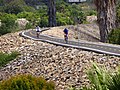
is a paved trail extending from El Segundo Boulevard south through residential neighborhoods to Greenleaf Boulevard. An equestrian trail runs along the...
15 KB (1,563 words) - 15:19, 14 December 2024
Century Freeway (I−105), and Western Avenue, between Century Boulevard and El Segundo Boulevard. Thomas Bones (1842–1929), farmer and land developer in this...
2 KB (91 words) - 15:21, 9 August 2024

Interstate 105 (California) (redirect from El Segundo Freeway)
El Segundo to Route 605. Route 105 was never fully constructed as it is defined. Currently, the western terminus of I-105 is at Sepulveda Boulevard (SR 1)...
25 KB (2,250 words) - 06:56, 2 June 2025
Wiseburn Unified School District (category El Segundo, California)
headquarters are on the grounds of the Da Vinci charter schools facility in El Segundo. Previously they were in Hawthorne. It was established on March 8, 1896...
17 KB (1,816 words) - 08:31, 23 May 2025
six miles. It extends from El Segundo Boulevard east of N. Parmelee Avenue(near Centennial High School) to Del Amo Boulevard near the Blue Line Del Amo...
37 KB (3,695 words) - 02:53, 30 May 2025