
The flag of Roraima is one of the official symbols of the state of Roraima in Brazil. The flag was designed by Mário Barreto, and instituted by state law...
4 KB (355 words) - 19:29, 13 March 2024

Roraima (Brazilian Portuguese: [ʁoˈɾajmɐ] or [ʁoˈɾɐ̃jmɐ]) is one of the 26 states of Brazil. Located in the country's North Region, it is the northernmost...
76 KB (7,778 words) - 12:46, 5 June 2025
Romania (1965–1989) Flag of Rondônia Flag of Roraima Flag of Russia Presidential Flag of Russia Flag of Rwanda Flag of Saint Lucia Flag of Saint Vincent and...
205 KB (10,904 words) - 15:54, 20 May 2025

to Flags of Brazil. This article is a list of Brazilian flags. This list shows the flags of the 26 Brazilian States and the Federal District. Flag of Brazil...
30 KB (179 words) - 22:18, 3 May 2025

The national flag of Brazil is a blue disc depicting a starry sky (which includes the Southern Cross) spanned by a curved band inscribed with the national...
43 KB (3,834 words) - 18:25, 7 June 2025
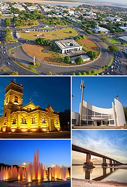
View; figuratively "Fairview") is the capital of the Brazilian state of Roraima. Situated on the western bank of the Branco River, the city lies 109 km from...
27 KB (2,045 words) - 20:22, 22 May 2025

(Portuguese pronunciation: [ˈawtu aˈlɛɡɾi]) is a city in the Brazilian state of Roraima. The population in 2020 was 15,380, and the area is 25,567 km². Its limits...
4 KB (151 words) - 17:21, 19 October 2024
a list of flags of states, territories, former, and other geographic entities (plus a few non-geographic flags) sorted by their combinations of dominant...
176 KB (7,663 words) - 17:58, 31 May 2025
Flags of the world's nations vary in the number of colours, ranging from one colour to more than forty.[citation needed] Abbasid Caliphate (750–1258)...
71 KB (3,130 words) - 20:08, 8 June 2025
This is a list of sovereign states by the date on which they adopted their current national flag. For most of these states, the date of flag adoption is...
38 KB (1,110 words) - 12:22, 28 May 2025
Uiramutã (category Municipalities in Roraima)
northeast of the state of Roraima in Brazil. Its population is 10,789 (as of 2020) and its area is 8,066 km2. It is the northernmost municipality of Brazil...
6 KB (402 words) - 17:32, 19 October 2024
page lists the country subdivision flags in South America. It is a part of the Lists of country subdivision flags, which is split into continents due...
81 KB (1,945 words) - 08:08, 9 April 2025

northeastern region of the Brazilian state of Roraima. Normandia covers 6,960 km2 (2,690 sq mi), and has an estimated population of 11,532 as of 2020 with a population...
9 KB (649 words) - 17:30, 19 October 2024

pronunciation: [bõˈfĩ]) is a municipality located in the mideast of the state of Roraima in Brazil. Its population is 12,557 and its area is 8,095 km2....
6 KB (340 words) - 17:26, 19 October 2024

The history of the territory that is now Roraima, a state at the extreme north of present-day Brazil is recent, but not thereby simple. Invaded numerous...
46 KB (5,691 words) - 22:01, 1 June 2025

Cantá (category Municipalities in Roraima)
located in the mideast of the state of Roraima in Brazil. Its population is 18,799 (2020) and its area is 7,665 km². The municipality of Cantá was established...
5 KB (239 words) - 17:27, 19 October 2024

Caracaraí (category Municipalities in Roraima)
of Roraima in Brazil. Its population is 22,283 and its area is 47,411 square kilometres (18,305 sq mi), making it the largest municipality in Roraima...
9 KB (398 words) - 15:10, 11 November 2024

Pacaraima (category Municipalities in Roraima)
pronunciation: [pakaˈɾajmɐ]) is a municipality located in the northwest of the state of Roraima in Brazil. It is second most northern municipality in Brazil, behind...
8 KB (649 words) - 09:47, 29 November 2024
official flag is the French flag. Only the French flag is officially recognized by the French constitution as the national flag, the green and yellow flag is...
119 KB (721 words) - 09:21, 8 June 2025
This is a list of all airline codes. The table lists the IATA airline designators, the ICAO airline designators and the airline call signs (telephony designator)...
3 KB (782 words) - 21:23, 6 June 2025
pronunciation: [iɾaˈsẽmɐ]) is a municipality located in the midwest of the state of Roraima in Brazil. Its population is 12,296 (2020) and its area is 14,413 km²...
3 KB (109 words) - 17:35, 19 October 2024

Santa Elena de Uairén (redirect from History of Santa Elena de Uairén)
its proximity to the Brazilian state of Roraima, Santa Elena sees a busy exchange between the two countries of Brazilian consumer products from Brazil...
9 KB (474 words) - 14:26, 11 April 2025

Ceará (redirect from Demographics of Ceará)
mixed martial arts. Fortaleza was one of the host cities of the 2014 FIFA World Cup. The state flag of Ceará, is one of the national symbols. The background...
49 KB (5,009 words) - 20:07, 21 April 2025

Amajari (category Municipalities in Roraima)
northwest of the state of Roraima in Brazil. Its population is 13,185 and its area is 28,472 km². It is the westernmost municipality in Roraima. The municipality...
4 KB (246 words) - 17:23, 19 October 2024

Pará (redirect from State of Pará)
Tocantins, Mato Grosso, Amazonas and Roraima. To the northwest are the borders of Guyana and Suriname, to the northeast of Pará is the Atlantic Ocean. The...
42 KB (4,241 words) - 09:10, 17 May 2025
Guyana (redirect from Co-operative Republic of Guyana)
border. Some of Guyana's highest mountains are Mount Ayanganna (2,042 m or 6,699 ft), Monte Caburaí (1,465 m or 4,806 ft) and Mount Roraima (2,772 m or...
117 KB (10,453 words) - 02:20, 8 June 2025
Brazil (redirect from Republic of Brazil)
the last three: Amapá and Roraima (which gained statehood status) and Fernando de Noronha, which became a state district of Pernambuco. Brazil is a developing...
296 KB (26,518 words) - 17:02, 8 June 2025

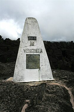
September 1907. In 1932, Juan Vicente Gómez agreed a point on the summit of Mount Roraima as the three-way boundary between Brazil, British Guiana and Venezuela...
20 KB (1,179 words) - 10:09, 15 March 2025
São João da Baliza (category Municipalities in Roraima)
ʒuˈɐ̃w da baˈʎizɐ]) is a municipality located in the southeast of the state of Roraima in Brazil. Its population is 8.858 (2022) and its area is 4,284 km2...
4 KB (143 words) - 17:40, 19 October 2024
Mucajaí (category Municipalities in Roraima)
pronunciation: [mukɐʒaˈi]) is a municipality located in the midwest of the state of Roraima in Brazil. Its population is 18,172 (2020) and its area is 12,461 km²...
5 KB (202 words) - 17:36, 19 October 2024