
Great-circle navigation or orthodromic navigation (related to orthodromic course; from Ancient Greek ορθός (orthós) 'right angle' and δρόμος (drómos) 'path')...
22 KB (4,006 words) - 15:40, 28 March 2025
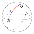
great-circle navigation, which also computes the azimuths at the end points and intermediate way-points. Because the Earth is nearly spherical, great-circle...
13 KB (1,920 words) - 08:30, 23 January 2025

Orthodrome (Great Circle), Great Ellipse and Geodetic Line (Geodesic) in Navigation. USA: CRC Press, Inc. ISBN 978-1-138-00004-9. Great Circle – from MathWorld...
7 KB (993 words) - 12:13, 7 April 2025
{\displaystyle a} in such a way as to map the great ellipse into a great circle, allowing the methods of great-circle navigation to be used: The ellipsoid can be stretched...
9 KB (1,353 words) - 03:06, 14 February 2025

formulas for solving a spherical triangle. (See the article on great-circle navigation.) For an ellipsoid of revolution, the characteristic constant defining...
73 KB (8,506 words) - 15:35, 22 April 2025

Mercator projection, a loxodromic course appears as a straight line. Great circle navigation Windrose network Map Portolan map Marine sandglass Compass rose...
2 KB (165 words) - 00:01, 15 April 2022

In navigation, bearing or azimuth is the horizontal angle between the direction of an object and north or another object. The angle value can be specified...
15 KB (1,960 words) - 07:26, 6 March 2025

negligible. Arc measurement Earth radius Spherical Earth Great-circle distance Great-circle navigation Ground sample distance Vincenty's formulae Meridian...
27 KB (4,054 words) - 15:09, 19 April 2025

in avionics Glossary of navigation terms Bearing (navigation) Breton plotter E6B Great circle Ground track Navigation Navigation room Rhumb line Bartlett...
5 KB (361 words) - 21:21, 11 January 2025
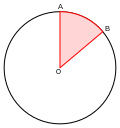
Central angle (category Circles)
n . {\displaystyle 2\pi /n.} Chord (geometry) Inscribed angle Great-circle navigation Clapham, C.; Nicholson, J. (2009). "Oxford Concise Dictionary of...
5 KB (582 words) - 23:24, 20 November 2023
Line. The shortest way to travel between two distant points is by great circle navigation, as known by ocean navigators for some time. This route shows as...
46 KB (6,247 words) - 00:43, 7 May 2025
Polar route (category Air navigation)
cap regions. The term "polar route" was originally applied to great circle navigation routes between Europe and the west coast of North America in the...
32 KB (3,508 words) - 01:57, 8 May 2025

long-distance trade by sea. Coastal navigation was practiced since the most ancient times. The biblical account of the great flood, where the Noah's Ark appears...
30 KB (2,841 words) - 10:39, 20 March 2025

The field of navigation includes four general categories: land navigation, marine navigation, aeronautic navigation, and space navigation. It is also the...
83 KB (9,369 words) - 14:32, 23 May 2025
can adopt zig-zag sailing patterns rather than more-efficient great-circle navigation. Sailing in zig-zags made computing a target angle more difficult...
6 KB (771 words) - 22:12, 16 April 2025

grabber. Air navigation Celestial navigation Dead reckoning Doppler navigation ECDIS Galileo positioning system Geodetic system Great-circle distance Marshall...
5 KB (503 words) - 00:46, 20 February 2023

distance between Lyttelton and Cape Horn, using Great-circle navigation, is partially inside the Antarctic Circle and about as far as 68 degrees south at the...
25 KB (3,309 words) - 00:09, 10 January 2025
after it was removed in FS2002. Previous versions did not allow great circle navigation at latitudes higher than 60 degrees (north or south), and at around...
40 KB (4,720 words) - 12:50, 20 March 2025

Plane sailing (category Navigation)
general meaning of any activity that is relatively straightforward. Great-circle navigation Mercator Sailing Mid-latitude sailing Parallel sailing Rhumb line...
2 KB (252 words) - 00:53, 19 February 2025
Rhumb line (category Navigation)
to continuously change bearings while travelling a great circle route makes rhumb line navigation appealing in certain instances. The point can be illustrated...
21 KB (2,870 words) - 08:32, 14 January 2025
formula determines the great-circle distance between two points on a sphere given their longitudes and latitudes. Important in navigation, it is a special case...
20 KB (2,836 words) - 03:06, 3 May 2025

latitude. Circle of illumination or terminator (star = Sun, Ho = 0 for places at Sunrise/Sunset). Almucantar Navigation Celestial navigation Intercept...
5 KB (695 words) - 11:31, 3 December 2024
Pseudo-range multilateration (category Radio navigation)
can be found in great-circle navigation. The distance R i {\displaystyle R_{i}} from the vehicle to station i is along a great circle will then be R i...
73 KB (9,850 words) - 15:55, 4 February 2025
Glossary of nautical terms (A–L) (redirect from Glossary of navigation terms)
classic form of drydock. graybeard great-circle navigation The practice of navigating a vessel along the arc of a great circle. Such routes yield the shortest...
312 KB (39,093 words) - 14:11, 24 May 2025

Spherical trigonometry (redirect from Neper's circle)
sphere, geodesics are great circles. Spherical trigonometry is of great importance for calculations in astronomy, geodesy, and navigation. The origins of spherical...
41 KB (6,784 words) - 13:26, 6 May 2025
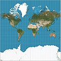
Mercator projection (section Marine navigation)
1569. In the 18th century, it became the standard map projection for navigation due to its property of representing rhumb lines as straight lines. When...
49 KB (6,858 words) - 17:00, 23 May 2025

Radio navigation or radionavigation is the application of radio waves to determine a position of an object on the Earth, either the vessel or an obstruction...
40 KB (5,315 words) - 22:23, 16 January 2025
Flight management system Great-circle distance Guidance, navigation and control Instrument landing system Radio navigation Receiver autonomous integrity...
21 KB (3,087 words) - 22:23, 29 March 2025
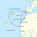
Volta do mar (category Navigation)
dependable phenomenon of the great permanent wind circle, the North Atlantic Gyre. This was a major step in the history of navigation, when an understanding...
6 KB (649 words) - 18:06, 29 June 2024
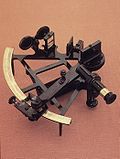
Sextant (category Celestial navigation)
A sextant is a doubly reflecting navigation instrument that measures the angular distance between two visible objects. The primary use of a sextant is...
22 KB (3,194 words) - 09:50, 21 May 2025