
The horizontal coordinate system is a celestial coordinate system that uses the observer's local horizon as the fundamental plane to define two angles...
9 KB (944 words) - 04:39, 7 January 2025

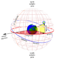
The equatorial coordinate system is a celestial coordinate system widely used to specify the positions of celestial objects. It may be implemented in spherical...
17 KB (1,657 words) - 07:37, 20 March 2025

+90°), as done in the horizontal coordinate system. (See graphic re "mathematics convention".) The spherical coordinate system of the physics convention...
43 KB (6,355 words) - 20:55, 14 April 2025

down (or down to up), such as the y-axis in the Cartesian coordinate system. The word horizontal is derived from the Latin horizon, which derives from the...
17 KB (2,140 words) - 20:39, 30 May 2025
Azimuth (category Horizontal coordinate system)
directions') is the horizontal angle from a cardinal direction, most commonly north, in a local or observer-centric spherical coordinate system. Mathematically...
14 KB (1,768 words) - 07:06, 20 June 2025

In geometry, a Cartesian coordinate system (UK: /kɑːrˈtiːzjən/, US: /kɑːrˈtiːʒən/) in a plane is a coordinate system that specifies each point uniquely...
41 KB (5,520 words) - 00:16, 1 June 2025
and contexts Horizontal coordinate system, in astronomy Horizontalism, in monetary circuit theory Horizontalism, in sociology Horizontal market, in microeconomics...
805 bytes (125 words) - 15:55, 19 November 2023

Local tangent plane coordinates (redirect from Topocentric coordinate system)
They are also known as local ellipsoidal system, local geodetic coordinate system, local vertical, local horizontal coordinates (LVLH), or topocentric coordinates...
6 KB (717 words) - 14:11, 13 February 2025

horizontal datum, map projection (except in the geographic coordinate system), origin point, and unit of measure. Thousands of coordinate systems have...
15 KB (1,570 words) - 12:19, 7 May 2025

The galactic coordinate system is a celestial coordinate system in spherical coordinates, with the Sun as its center, the primary direction aligned with...
15 KB (1,383 words) - 12:42, 19 June 2025

Zenith (category Horizontal coordinate system)
12 hours from solar noon. In astronomy, the altitude in the horizontal coordinate system and the zenith angle are complementary angles, with the horizon...
7 KB (854 words) - 16:41, 4 May 2025

In mathematics, the polar coordinate system specifies a given point in a plane by using a distance and an angle as its two coordinates. These are the...
49 KB (6,702 words) - 21:47, 13 May 2025

A geographic coordinate system (GCS) is a spherical or geodetic coordinate system for measuring and communicating positions directly on Earth as latitude...
23 KB (2,540 words) - 22:18, 14 May 2025

positioning of a celestial object by the horizontal system varies with time, but is a useful coordinate system for locating and tracking objects for observers...
29 KB (3,971 words) - 18:25, 17 April 2025

can then be used to derive the position of the object in the horizontal coordinate system, consisting of the altitude and azimuth. The coordinates of celestial...
6 KB (662 words) - 17:07, 22 October 2023

A cylindrical coordinate system is a three-dimensional coordinate system that specifies point positions around a main axis (a chosen directed line) and...
18 KB (2,117 words) - 18:59, 17 April 2025
Solar azimuth angle (category Horizontal coordinate system)
azimuth angle is the azimuth (horizontal angle with respect to north) of the Sun's position. This horizontal coordinate defines the Sun's relative direction...
11 KB (1,518 words) - 02:43, 7 September 2024
In astronomy, the ecliptic coordinate system is a celestial coordinate system commonly used for representing the apparent positions, orbits, and pole orientations...
14 KB (1,331 words) - 02:25, 16 December 2024
coordinate system of the Earth, the fundamental plane is the Equator. Astronomical coordinate systems have varying fundamental planes: The horizontal...
2 KB (178 words) - 15:13, 9 January 2025

Horizon (category Horizontal coordinate system)
eyes of the observer. It is the fundamental plane of the horizontal coordinate system, the locus of points that have an altitude of zero degrees. While...
29 KB (3,997 words) - 22:24, 26 May 2025
Solar zenith angle (category Horizontal coordinate system)
elsewhere. Azimuth Solar azimuth angle Horizontal coordinate system List of orbits Photovoltaic mounting system § Orientation and inclination Position...
8 KB (1,226 words) - 09:50, 2 May 2025

The supergalactic coordinate system is a reference frame for the supercluster of galaxies that contains the Milky Way galaxy, referenced to a local relatively...
7 KB (927 words) - 03:24, 17 July 2024
ground vehicles/cars. It is a type of geographic coordinate system. There are several options for horizontal position representations, each with different...
8 KB (756 words) - 05:26, 11 August 2024

Position of the Sun (category Dynamics of the Solar System)
position in the ecliptic coordinate system, convert to the equatorial coordinate system, and convert to the horizontal coordinate system, for the observer's...
25 KB (3,398 words) - 22:39, 16 April 2025

A projected coordinate system – also called a projected coordinate reference system, planar coordinate system, or grid reference system – is a type of...
21 KB (2,805 words) - 00:44, 11 June 2025
end points they used from the star altitudes in a celestial horizontal coordinate system. As it is thought that one Arabian ell represented 49.33 centimetres...
4 KB (340 words) - 15:47, 23 October 2024

Meridian (astronomy) (category Astronomical coordinate systems)
poles at the opposite ends. In another approach known as the horizontal coordinate system, the meridian is divided into the local meridian, the semicircle...
4 KB (417 words) - 19:16, 19 June 2025

computations. One of his areas of study was that of the altazimuth or horizontal coordinate system, as well as bring one of the four observers of the transit circle...
6 KB (517 words) - 10:38, 28 March 2025

Gaussian grid (category Geographic coordinate systems)
A Gaussian grid is used in the earth sciences as a gridded horizontal coordinate system for scientific modeling on a sphere (i.e., the approximate shape...
2 KB (265 words) - 05:13, 22 May 2024
between a weapon barrel and the horizontal plane Elevation (astronomy), one component of the horizontal coordinate system Elevation (view), used in architectural...
2 KB (289 words) - 21:11, 11 March 2025