Integration of traffic data with navigation systems enables navigation systems to use traffic and other related data to optimise routing and travel times...
3 KB (369 words) - 16:51, 8 June 2024

have a network of sensors on motorways and trunk roads in the UK). GPS units (see Integration of traffic data with navigation systems) Smartphones Radio...
6 KB (721 words) - 05:46, 3 February 2025

Automotive navigation systems are crucial for the development of self-driving cars. Automotive navigation systems represent a convergence of a number of diverse...
21 KB (2,335 words) - 22:46, 5 May 2025

other systems through integration of traffic data with navigation systems. Additionally, the roadway network has been increasingly fitted with additional...
48 KB (6,264 words) - 16:43, 25 March 2025
driver-assistance systems (ADAS). GDF is commonly used for data interchange in many industries such as automotive navigation systems, fleet management...
5 KB (634 words) - 16:12, 22 April 2024

applied, from basic management systems such as car navigation; traffic signal control systems; container management systems; variable message signs; automatic...
35 KB (4,240 words) - 18:24, 19 January 2025

in many countries. When data is integrated directly into a navigation system, traffic information can be used in the system's route calculation. Detailed...
76 KB (8,367 words) - 05:38, 5 May 2025

AIS integrates a standardized VHF transceiver with a positioning system such as a Global Positioning System receiver, with other electronic navigation sensors...
90 KB (11,133 words) - 15:14, 14 March 2025
creation and support of the ground-based electronic hardware and software systems used to support air navigation and air traffic management. In India...
3 KB (358 words) - 17:13, 10 October 2024
Waze (redirect from Criticism of Waze)
started collecting data for its traffic management system. Rio collects real-time data both from drivers who use the Waze navigation app and pedestrians...
36 KB (3,657 words) - 22:20, 27 April 2025
the foundational systems, the FAA then identified key enabling systems that improve communications, navigation, surveillance, traffic flow automation,...
249 KB (24,615 words) - 03:50, 9 April 2025

inertial navigation systems rather than the ground-based beacons, and so cost–benefit analysis was not in favour of maintaining the RNAV routes system. RNAV...
11 KB (1,326 words) - 09:50, 14 February 2025

TomTom (category Automotive navigation systems)
to the specified destination. Some TomTom systems also integrate with mobile phones using Bluetooth, traffic congestion maps or to actually take calls...
77 KB (7,440 words) - 14:41, 7 May 2025
Force and operated by Mission Delta 31. It is one of the global navigation satellite systems (GNSS) that provide geolocation and time information to a GPS...
185 KB (19,124 words) - 03:18, 9 April 2025

US Satnav satellite system. As GNSS navigation systems became more and more widespread and popular, the pricing of such systems began to fall, and their...
39 KB (4,142 words) - 23:23, 17 April 2025
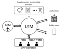
aircraft system traffic management (UTM) is an air traffic management ecosystem under development for autonomously controlled operations of unmanned aerial...
6 KB (668 words) - 13:38, 2 July 2024
but it is often available for automotive navigation systems. In many countries only encrypted traffic data is broadcast, and so an appropriate decoder...
40 KB (4,181 words) - 03:08, 3 May 2025
Here WeGo (category Android (operating system) software)
turn-by-turn navigation (including for walking and cycling) and traffic and public transport data. It can work online and offline: maps of countries and...
27 KB (2,554 words) - 16:19, 30 April 2025

aircraft systems, such as fuel and electrical systems (see EICAS, below). As with the PFD, the MFD can change the color or shape of the data to alert...
15 KB (1,922 words) - 20:50, 13 December 2024
GNSS augmentation (redirect from Satellite navigation augmentation system)
and availability, through the integration of external information into the calculation process. There are many such systems in place, and they are generally...
15 KB (1,588 words) - 13:54, 20 April 2025
Nexar (category Software companies of the United States)
which allows customers to extract data from the API and integrate it into their routing algorithms. This integration prevents vehicles from being directed...
11 KB (1,043 words) - 22:39, 6 February 2025

Chartplotter (category Navigational aids)
used in marine navigation that integrates GPS data with an electronic navigational chart (ENC). The chartplotter displays the ENC along with the position...
6 KB (782 words) - 22:54, 20 July 2024
Inertial measurement unit (category Inertial navigation)
automotive navigation systems or vehicle tracking systems, giving the system a dead reckoning capability and the ability to gather as much accurate data as possible...
18 KB (2,139 words) - 21:29, 1 March 2025

Garmin G1000 (category Articles with short description)
(containing map, traffic, and terrain information), and systems annunciation data. The second display, typically positioned to the right of the PFD, operates...
18 KB (2,222 words) - 19:40, 22 February 2025
System Wide Information Management (SWIM) is a global Air Traffic Management (ATM) industry initiative to harmonize the exchange of Aeronautical, Weather...
6 KB (779 words) - 06:39, 7 January 2025

Marine navigation is the art and science of steering a ship from a starting point (sailing) to a destination, efficiently and responsibly. It is an art...
30 KB (2,841 words) - 10:39, 20 March 2025
and markets in the fields of: Tactical data links Simulation and virtual-reality systems Navigation and geolocation systems Electronic warfare Mission-critical...
8 KB (778 words) - 20:23, 29 April 2025
Car app (section Navigation apps)
software for cars include allowing data input while moving, traffic jam assistance, diagnostics and lane-keeping. These pieces of software can be standalone or...
12 KB (1,411 words) - 15:43, 24 December 2024
performance-based navigation (PBN) specifies that aircraft required navigation performance (RNP) and area navigation (RNAV) systems performance requirements...
18 KB (2,433 words) - 04:44, 6 March 2024

Computer cartography (redirect from History of digital mapping)
Positioning System (GPS) satellite network. This can allow real-time automated map generation for tasks such as automotive navigation systems. In the 1959...
11 KB (1,230 words) - 13:57, 4 May 2025