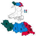
The Isle of Anglesey electoral boundary changes in 2012 reduced the numbers of electoral wards to the Isle of Anglesey County Council from 40 to 11. This...
5 KB (517 words) - 11:21, 9 February 2023

The Isle of Anglesey County Council (Welsh: Cyngor Sir Ynys Môn) is the local authority for the Isle of Anglesey, a principal area with county status in...
32 KB (2,731 words) - 20:53, 3 May 2025

immediately, with the changes taking effect on 2 April 1996. The changes were: Conwy from "Aberconwy and Colwyn" Isle of Anglesey from "Anglesey" Gwynedd from...
15 KB (814 words) - 18:54, 24 June 2025
independent candidate, Richard Dew, by 261 votes. Isle of Anglesey electoral boundary changes 2012 "Anglesey council election: 107 candidates for 30 seats"...
4 KB (307 words) - 12:12, 10 July 2025
Politics of Wales Local government in Wales List of electoral wards in England by constituency Isle of Anglesey electoral boundary changes 2012 The Parliamentary...
27 KB (2,251 words) - 21:15, 13 April 2025
on electoral wards for an explanation of this list. Electoral wards to Isle of Anglesey County Council prior to the 2012 electoral boundary changes: *...
3 KB (86 words) - 01:39, 4 July 2025
Prior to the 2012 Anglesey electoral boundary changes Valley was an electoral ward to the Isle of Anglesey County Council. It is now part of the larger...
8 KB (564 words) - 18:02, 3 July 2025

Ynys Gybi (electoral ward) "Election Maps". Ordnance Survey. Retrieved 3 December 2017. "Isle of Anglesey (Electoral Arrangements) Order 2012" (PDF). legislation...
6 KB (205 words) - 16:48, 21 December 2022
Isles), Ynys Môn (Isle of Anglesey) and two on the Isle of Wight. The total number of constituencies is fixed at 650. the area of a constituency must...
25 KB (2,698 words) - 03:33, 5 May 2025

Penmynydd (redirect from Penmynydd, Anglesey)
Council. Following the 2012 Isle of Anglesey electoral boundary changes Penmynydd was transferred to a new multi-councillor ward of Aethwy. Pointon, G. E...
8 KB (751 words) - 19:33, 31 March 2025
councillors to the Isle of Anglesey County Council. The Ynys Gybi ward was created following the Isle of Anglesey electoral boundary changes in 2012, which created...
6 KB (361 words) - 10:41, 9 December 2024
working-class conurbations of Deeside. The western areas, including the Isle of Anglesey (Ynys Môn), are largely rural. Although Anglesey and Gwynedd are home...
42 KB (671 words) - 16:24, 1 May 2025

Aberffraw (redirect from Aberffraw, Anglesey)
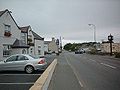
west coast of the Isle of Anglesey in Wales. The village is 9 miles from the island's county town, Llangefni, and is on the west bank of the Afon Ffraw...
20 KB (2,080 words) - 19:35, 11 June 2025
Town Council. Prior to the Isle of Anglesey electoral boundary changes in 2012 Kingsland was also a ward for the Isle of Anglesey County Council, electing...
3 KB (221 words) - 12:30, 12 October 2023
Rhosneigr (category Former wards of Anglesey)
to the 2012 Anglesey electoral boundary changes an electoral ward in the same name existed, electing a county councillor to the Isle of Anglesey County...
8 KB (800 words) - 18:45, 10 July 2025

decrease of any UK country or region. Wales has one 'protected constituency' not subject to UK electoral quotas, Ynys Môn on the Isle of Anglesey, where...
53 KB (1,238 words) - 07:14, 31 May 2025

from the 1870s. Prior to the 2012 Anglesey electoral boundary changes Maeshyfryd was an electoral ward to the Isle of Anglesey County Council. It generally...
2 KB (200 words) - 17:42, 21 December 2022

ward. The Aethwy ward was created following the Isle of Anglesey electoral boundary changes in 2012, which created 11 multi-councillor wards from 40...
3 KB (304 words) - 02:25, 7 December 2024

in 2013? Isle of Anglesey BBC News Anglesey council election postponed for one year to 2013 (17 January 2012) The Isle of Anglesey (Electoral Arrangements)...
27 KB (223 words) - 18:20, 26 June 2024

Caernarfonshire (redirect from County of Caernarvon)
separated it from Anglesey. The county was largely mountainous. A large part of the Snowdonian Range lay in the centre and south-east of the former county...
23 KB (1,643 words) - 20:55, 2 July 2025
Trearddur (category Former wards of Anglesey)
Following the Isle of Anglesey electoral boundary changes Trearddur became part of a larger Ynys Gybi ward, which includes part of Holyhead. At the local...
7 KB (674 words) - 20:43, 26 June 2025

Gwynedd Council (category Government of Gwynedd)
lower-tier districts: Aberconwy, Arfon, Dwyfor, Meirionnydd, and Ynys Môn-Isle of Anglesey. Local government across Wales was reorganised again in 1996 under...
30 KB (2,141 words) - 14:01, 28 May 2025

Pentraeth (category Former wards of Anglesey)
Cadw/ICOMOS Register of Parks and Gardens of Special Historic Interest in Wales. Prior to the 2012 Anglesey electoral boundary changes an electoral ward in the...
6 KB (645 words) - 19:46, 14 October 2024

created with the merger of Anglesey with Caernarfonshire and Merionethshire in 1974, led by Gwynedd County Council. In 1996 Anglesey became a separate county...
21 KB (661 words) - 13:56, 19 December 2024

2013 Review" The Boundary Commission for England — retrieved 2012-12-19 Archived 29 October 2012 at the Wayback Machine. "Electoral statistics, UK: 2017"...
117 KB (1,184 words) - 13:44, 24 June 2025
entity distinct from the mainland, the Isle of Wight has always fought to have this identity recognised. The Isle of Wight is currently a ceremonial and...
49 KB (3,037 words) - 08:50, 8 May 2025
Braint (category Former wards of Anglesey)
population of the ward was 1,517 at the 2011 Census. Following the 2012 Isle of Anglesey electoral boundary changes Braint (and Llanfair PG) became part of a larger...
2 KB (173 words) - 21:27, 29 May 2023
Rhosyr (category Anglesey geography stubs)
Until the 2012 Isle of Anglesey electoral boundary changes Rhosyr was also an electoral ward for the Isle of Anglesey County Council. However, since the...
3 KB (237 words) - 19:45, 14 October 2024

Bangor, Gwynedd (redirect from History of Bangor, Gwynedd)
connect the city to the Isle of Anglesey. The origins of the city date back to the founding of a monastic establishment on the site of Bangor Cathedral by...
51 KB (5,545 words) - 09:21, 30 June 2025

boundaries between 1974 and 1996 "North West Wales" — Gwynedd with boundaries between 1974 and 1996 (excluding Meirionnydd); (Modern Isle of Anglesey...
31 KB (2,922 words) - 16:44, 24 May 2025