
The Kaiwharawhara Stream is a stream in the North Island of New Zealand – it flows through the northwestern part of New Zealand's capital, Wellington....
8 KB (632 words) - 02:52, 6 February 2025

of the city on the western shore of Wellington Harbour, where the Kaiwharawhara Stream reaches the sea from its headwaters in Karori. It is a largely commercial...
7 KB (719 words) - 03:08, 22 May 2025

Kaiwharawhara Stream's main tributary. The two meet in the lower reaches of the Kaiwharawhara River in parkland. "Greater Wellington - Kaiwharawhara Catchment"...
2 KB (86 words) - 02:26, 13 April 2024

cloud." Karori experienced a gold rush when the valley of the Upper Kaiwharawhara Stream became subject to intensive gold-mining activity between 1869 and...
41 KB (3,460 words) - 07:10, 25 June 2025
Kaituna River (Tasman) Kaiwaka River Kaiwakawaka River Kaiwara River Kaiwharawhara Stream Kaiwhata River Kaka River Kakanui River Kakapo River Kākāpōtahi River...
31 KB (2,843 words) - 22:37, 11 June 2025

Kaiwharawhara railway station, a former railway station on the North Island Main Trunk and the Wairarapa Line in Wellington in New Zealand, closed in...
18 KB (1,584 words) - 09:49, 24 November 2024
Wadestown to the south. Its border runs on the Korimako Stream that flows south into the Kaiwharawhara Stream and then flows down the Ngaio Gorge into Wellington...
15 KB (1,381 words) - 08:59, 20 December 2024

used for farming. Following the discovery of alluvial gold in the Kaiwharawhara stream in 1869, there was a small 'gold rush' in the area. This was soon...
22 KB (2,011 words) - 23:59, 11 June 2025

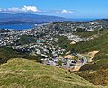
the catchment area of the northeast flowing Kaiwharawhara Stream, which has several gullies and side streams (some with small waterfalls) and is surrounded...
24 KB (2,453 words) - 23:47, 6 June 2025

Garden, Zealandia Wildlife Sanctuary and, on the fill over the piped Kaiwharawhara Stream, Ian Galloway Park with its Rugby fields and dog exercise area. There...
21 KB (2,170 words) - 09:12, 5 February 2025

Tawa Flat deviation (section Kaiwharawhara station)
has been closed for short periods due to fires, flooding of the Kaiwharawhara stream, a burst stormwater pipe near the southern portal of No. 2 tunnel...
35 KB (4,985 words) - 17:40, 21 April 2025

the Ngaio Gorge to an intersection with Kaiwharawhara Road. It then follows the course of the Kaiwharawhara stream up the Ngaio Gorge to the intersection...
37 KB (3,714 words) - 22:53, 18 January 2025
River Kaiwharawhara Stream Korimako Stream Wharemauku Stream Waikanae River Ngatiawa River Rangiora River Reikorangi Stream Maungakotukutuku Stream, Ōtaki...
2 KB (172 words) - 23:15, 22 May 2025

farmer; in 1861 he had a flock of 165 sheep, to be washed in the Kaiwharawhara Stream before shearing. He subdivided his farm in 1915, but Wilton was semi-rural...
8 KB (802 words) - 00:41, 13 June 2025
a grille for use as an emergency median). It stretches from the Kaiwharawhara Stream to past Thorndon Quay. The overbridge was built in three stages between...
24 KB (2,643 words) - 19:43, 15 May 2025

Mākara Beach, from today's Awarua Street. The area was named Upper Kaiwharawhara or Upper Kaiwarra in the 1840s by Captain Edward Daniell who purchased...
31 KB (3,137 words) - 05:20, 10 June 2025
walk several miles along the poorly-formed Hutt Road to the school at Kaiwharawhara. Ngauranga School had closed by early 1903. The resident population...
31 KB (2,998 words) - 17:25, 31 May 2025
City, excluding Tawa, Churton Park, Glenside, Broadmeadows, Ngauranga, Kaiwharawhara, and central Wellington (bound by State Highway 1 and Kent Terrace)...
42 KB (4,479 words) - 00:22, 20 June 2025

and relocated to its current site of Wellington City, the track from Kaiwharawhara across Paerau hill was used more. This track joined with the Korokoro...
7 KB (763 words) - 01:39, 21 August 2024
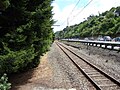
diverted the North Island Main Trunk railway from Thorndon through Kaiwharawhara and two significant new tunnels to the Tawa valley to provide a shorter...
46 KB (5,432 words) - 02:51, 29 May 2025
shoreline of Wellington Harbour. In July 1873, the railway reached Kaiwharawhara, followed by Ngauranga in early 1874 and Lower Hutt on 14 April 1874...
41 KB (4,294 words) - 23:21, 15 April 2025

Kaeaea (also known as Taringa Kuri, or "Dog's Ear"), then living at Kaiwharawhara in subservience to Te Rauparaha.: 113–115 Ngāti Rangatahi, although...
42 KB (5,110 words) - 00:54, 28 May 2025
from Wellington to Porirua in New Zealand. It ran from Kaiwarra (now Kaiwharawhara) up the Ngaio Gorge to Ngaio (then called Crofton), Khandallah, Johnsonville...
10 KB (1,424 words) - 23:44, 26 March 2025

opened there. In June 1875 a flag station was opened near the Korokoro Stream, just north of the present station footbridge. It was named Koro-Koro as...
16 KB (1,582 words) - 09:38, 4 June 2025

Gorge and Ngaio Gorge roads were closed due to heavy flooding around Kaiwharawhara and the bottom of the Ngauranga Gorge road, and trains were cancelled...
13 KB (1,388 words) - 14:36, 8 February 2025
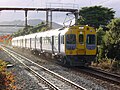
hourly (off-peak). Trains stop at the following stations: Wellington Kaiwharawhara (station closed 2013) Ngauranga Petone Western Hutt Melling The Melling...
22 KB (2,458 words) - 19:49, 20 April 2025

storm in 1976, Ngauranga Gorge was closed due to heavy flooding around Kaiwharawhara and the bottom of the Ngauranga Gorge road. The extensive flooding cut...
12 KB (1,312 words) - 02:30, 11 May 2025

View from Tūteremoana, looking south along the steep cliffs towards Kaiwharawhara Point List of islands of New Zealand Kāpiti Coast District Council....
53 KB (5,023 words) - 06:54, 25 May 2025
during WW II to serve the nearby hospital. On or near the site of the Silver Stream Railway's McKirdy station. i Near Mackays Crossing. j On closure relocated...
29 KB (1,202 words) - 15:51, 27 August 2024

Wairarapa Line (section Silver Stream Railway)
bridge across the Hutt River, replacing a section of line now used by Silver Stream Railway The Rimutaka Incline was difficult, costly and time-consuming to...
67 KB (4,697 words) - 16:26, 25 June 2025