
Kharimkotan (Russian: Харимкотан); Japanese 春牟古丹島; Harimukotan-tō, alternatively Harumukotan-tō or 加林古丹島; Karinkotan-tō) is an uninhabited volcanic island...
7 KB (702 words) - 23:39, 24 January 2025

温禰古丹島(おんねこたんとう) Onwakotan Mussel Kuroisi, Nemo, Shestakov 425 km2 (164 sq mi) 0 Kharimkotan Харимкотан 春牟古丹島(はりむこたんとう) 春牟古丹島(はるむこたんとう) Harimukotan, Harumukotan Sunazhma...
52 KB (4,579 words) - 23:48, 10 May 2025
28295–28326. Bibcode:2000JGR...10528295S. doi:10.1029/2000JB900120. "Kharimkotan". Global Volcanism Program. Smithsonian Institution. "Cerro Azul". Global...
77 KB (2,015 words) - 12:16, 23 May 2025
450 (Sea of Okhotsk) Sea of Okhotsk Passing between the islands of Kharimkotan and Ekarma in Russia's Kuril Island chain 49°0′N 154°22′E / 49.000°N...
53 KB (1,322 words) - 00:25, 2 April 2025
earthquakes have also occurred at Mount Yasur in 1878, Mount Okmok in 1878 and Kharimkotan in 1933. Earthquakes caused by tectonic processes at volcanoes are also...
12 KB (1,301 words) - 22:07, 12 May 2025
March 17, 1963 5 Bezymianny Kamchatka 1.9 1.9 Unknown March 30, 1956 5 Kharimkotan Kuril Islands 1 1 Unknown 1933 5 Quizapú Andean Volcanic Belt 9.5 9...
71 KB (2,311 words) - 21:52, 19 May 2025
450 (Sea of Okhotsk) Sea of Okhotsk Passing between the islands of Kharimkotan and Ekarma in Russia's Kuril Island chain 49°0′N 154°22′E / 49.000°N...
23 KB (1,705 words) - 23:45, 2 April 2025
Global Volcanism Program. Smithsonian Institution. "Ebeko". PeakVisor. "Kharimkotan". Global Volcanism Program. Smithsonian Institution. "Pik Severgin"....
119 KB (2,491 words) - 17:02, 7 April 2025

154°59' Makanrushi 49 1169 49°46' 154°26' Onekotan 425 1324 49°27' 154°46' Kharimkotan 68 1157 49°07' 154°32' Chirinkotan 6 724 48°59' 153°29' Ekarma 30 1170...
4 KB (150 words) - 07:37, 7 November 2024

Shashikotan (捨子古丹, "kombu village") Chirinkotan (知林古丹, "mudslide village") Kharimkotan (春牟古丹, "village of many cardiocrinum") Batchelor, John (1905). An Ainu-English-Japanese...
6 KB (664 words) - 01:44, 27 September 2023
Rasshua on Rasshua Island Sarychev Peak on Matua Island Severgin on Kharimkotan Island Sinarka on Shiashkotan Island Snow on Chirpoy Island Tao-Rusyr...
7 KB (746 words) - 09:10, 4 May 2024

0 0 Onekotan Онекотан 温禰古丹島 Mussel Kuroisi, Nemo, Shestakov 425.0 0 Kharimkotan Харимкотан 春牟古丹島 Harimukotan, Harumukotan Sunazhma Severgin Bay 70.0...
7 KB (625 words) - 17:38, 28 October 2024

is a strait that separates the islands of Onekotan to the north from Kharimkotan to the south. It is 12 km (7.5 mi) wide. The flood tidal current in the...
887 bytes (100 words) - 16:24, 9 March 2025
volcanic peak, is 28 kilometers (17 mi) to the northwest of Onekotan; and Kharimkotan, with a 1,210-meter (3,970 ft) high volcano, is 15 kilometers (9.3 mi)...
11 KB (1,229 words) - 23:26, 4 May 2025
35; 152.475 (Ketoi) 1960 Kharimkotan 1145 3757 49°07′12″N 156°30′29″E / 49.12°N 156.508°E / 49.12; 156.508 (Kharimkotan) 1933 Kolokol Group 1328 4357...
24 KB (98 words) - 02:52, 14 March 2025
Russian chemist, mineralogist, and geologist Pik Severgin, volcano on Kharimkotan island Severgin Bay, on the Kuril Islands This disambiguation page lists...
214 bytes (56 words) - 02:21, 30 December 2019
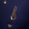
Onekotan Island (center), with Makanrushi at upper left and Kharimkotan at bottom. North at top....
5 KB (494 words) - 00:34, 26 October 2024