M'Clure Bay (variant: McClure Bay) is a Peel Soundmap waterway in the Qikiqtaaluk Region, Nunavut, Canada. It is located on the western side of Somerset...
2 KB (215 words) - 21:47, 24 August 2024

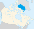
Hudson Bay, sometimes called Hudson's Bay (usually historically), is a large body of saltwater in northeastern Canada with a surface area of 1,230,000 km2...
54 KB (6,228 words) - 01:04, 15 July 2025
located north of M'Clure Bay. The closest hamlet is Resolute, located about 148 km (92 mi) to the north on Cornwallis Island. "Birmingham Bay". Geographical...
1 KB (77 words) - 22:47, 31 May 2024

The M'Clure Strait (sometimes rendered McClure Strait) is a strait on the edge of the Canadian Northwest Territories. It forms the northwestern end of...
4 KB (467 words) - 07:19, 23 January 2025

Robert McClure (redirect from Robert John le Mesurier M'Clure)
Expedition HMS Alert Nares HMS Discovery Stephenson Markham Lady Franklin Bay Expedition Greely Lockwood Brainard Nansen's Fram expedition Fram Nansen...
9 KB (893 words) - 14:20, 11 April 2025
located on the western side of Somerset Island. It is located north of M'Clure Bay. The closest hamlet is Resolute, located about 150 km (93 mi) to the...
2 KB (155 words) - 21:33, 30 May 2024

James Bay (French: Baie James, pronounced [bɛ dʒɛmz]; Cree: ᐐᓂᐯᒄ, romanized: Wînipekw, lit. 'dirty water') is a large body of water located on the southern...
17 KB (2,048 words) - 20:36, 4 July 2025

Mercy Bay is a Canadian Arctic waterway in the Northwest Territories. It is a southern arm of M'Clure Strait on northeast Banks Island. The mouth of Castel...
3 KB (253 words) - 17:04, 3 September 2024
Baffin Bay (Inuktitut: Saknirutiak Imanga; Greenlandic: Avannaata Imaa; French: Baie de Baffin; Danish: Baffinsbugten), located between Baffin Island...
22 KB (2,431 words) - 12:42, 22 July 2025
entrance to the bay is marked by Fitzjames Island on the west and Irving Island to the east. The bay opens to Queen Maud Gulf. The bay was one of a series...
5 KB (496 words) - 16:44, 31 May 2025

Canadian Arctic Rift System (redirect from Labrador Sea–Baffin Bay rift system)
Sound, M'Clure Strait, Viscount Melville Sound and Barrow Strait. With a length of over 1,100 km (680 mi), Parry Channel connects Baffin Bay in the east...
55 KB (6,287 words) - 15:04, 14 June 2025

Prince Patrick Island (redirect from Mould Bay)
of the least accessible parts of Canada. Located at the entrance of the M'Clure Strait, Prince Patrick Island is uninhabited. The first known sighting...
15 KB (813 words) - 23:24, 19 July 2025

Passage. The Parry Channel leads 600 mi (970 km) west from Baffin Bay to the strait or M'Clure Strait to the northwest. Robert McClure reached it from the west...
3 KB (322 words) - 10:33, 7 June 2025

Frobisher Bay is an inlet of the Davis Strait in the Qikiqtaaluk Region of Nunavut, Canada. It is located in the southeastern corner of Baffin Island...
7 KB (749 words) - 16:24, 8 June 2025
Ungava Bay (/ʊŋˈɡeɪvə, -ˈɡɑː-/; French: baie d'Ungava, pronounced [bɛ duŋɡava]; Inuktitut: ᐅᖓᕙ ᑲᖏᖅᓗᒃ/ungava kangiqluk) is a bay in Nunavut, Canada separating...
5 KB (582 words) - 20:04, 4 May 2025

John Wilson (Puritan minister) (category English emigrants to Massachusetts Bay Colony)
2014. M'Clure 1870, p. 34. M'Clure 1870, p. 35. M'Clure 1870, p. 38. M'Clure 1870, p. 41. M'Clure 1870, p. 42. Winship 2002, p. 85. M'Clure 1870, p...
41 KB (5,607 words) - 22:24, 15 March 2025
Castel Bay is a Canadian Arctic waterway in the Northwest Territories. It is a southern arm of M'Clure Strait on northeast Banks Island. The mouth of...
2 KB (115 words) - 17:43, 3 September 2024
Wager Bay or Ukkusiksalik Bay is long narrow inlet in the Kivalliq Region of Nunavut, Canada, which opens east into Roes Welcome Sound at the northwest...
4 KB (306 words) - 18:41, 23 June 2024
Simpson Peninsula. Helen Island lies in the bay. Pelly Bay is named after Sir John Pelly, governor of the Hudson's Bay Company, that managed the British territory...
4 KB (295 words) - 15:28, 23 May 2024

to its south. The Beaufort Sea lies to its west, and to its northeast M'Clure Strait separates the island from Prince Patrick Island and Melville Island...
13 KB (1,275 words) - 19:25, 21 June 2025

on the northern shore of the bay with Resolute Bay Airportmap to the northwest. The Inuit associated with Resolute Bay are called Qausuittuq and the...
7 KB (564 words) - 19:40, 2 September 2024

Grays Bay is an Arctic waterway in the Kitikmeot Region, Nunavut, Canada. It is located in Coronation Gulf with Hepburn Island at its mouth. The Tree...
5 KB (525 words) - 05:39, 4 June 2025
Wilmot and Crampton Bay is an Arctic waterway in the Kitikmeot Region, Nunavut, Canada . It is located on the eastern edge of Queen Maud Gulf, running...
3 KB (314 words) - 18:10, 23 May 2024
Tasiujaq (Inugsuin Fiord) (redirect from Igloo Bay)
Tasiujaq, formerly Igloo Bay, is an uninhabited bay of Baffin Island in the Qikiqtaaluk Region, Nunavut, Canada. It flows into Inugsuin Fiord and then...
1 KB (83 words) - 01:28, 11 November 2024
Tasiujaq (Foxe Basin) (redirect from Murray Maxwell Bay)
Tasiujaq (Inuktitut syllabics: ᑕᓯᐅᔭᖅ) formerly Murray Maxwell Bay is an uninhabited waterway in the Qikiqtaaluk Region, Nunavut, Canada. It is located...
2 KB (190 words) - 21:17, 26 August 2024
Cameron Bay is an Arctic waterway in the Qikiqtaaluk Region, Nunavut, Canada. Located off northeastern Cameron Island, the bay is an arm of the Arctic...
1 KB (60 words) - 21:49, 16 June 2024

via Barrow Strait, lies Lancaster Sound, leading into Baffin Bay; westward lies the M'Clure Strait and the Arctic Ocean / Beaufort Sea. The sound is a part...
2 KB (161 words) - 14:33, 11 February 2025
Lady Franklin Bay is an Arctic waterway in the Qikiqtaaluk Region, Nunavut, Canada. The bay is located in Nares Strait, northwest of Judge Daly Promontory...
6 KB (727 words) - 14:16, 12 December 2024
East of the sound lies Baffin Bay; to the west lies Viscount Melville Sound. Further west, a traveller would enter the M'Clure Strait before heading into...
15 KB (1,367 words) - 09:36, 17 June 2025
Peninsula, the bay is an arm of Byam Martin Channel. Eden Bay and Weatherall Bay are nearby. "Sherard Bay". Geographical Names Data Base. Natural Resources Canada...
1 KB (58 words) - 21:40, 2 September 2024