
State Route 136 (SR 136) is a numbered state highway in Maine, United States. It begins with SR 125 at the junction of U.S. Route 1 (US 1) in Freeport...
3 KB (115 words) - 05:10, 6 April 2023
(former) Maine State Route 136 Maryland Route 136 Massachusetts Route 136 M-136 (Michigan highway) New Hampshire Route 136 New Mexico State Road 136 New York...
5 KB (368 words) - 23:32, 4 April 2024

State Route 9 (SR 9) is a numbered state highway in Maine, running from the New Hampshire border at Berwick in the west to the Canada–US border with New...
21 KB (588 words) - 08:29, 21 May 2024
State routes in Maine are highways within the Maine State Highway System that are signed and maintained by the Maine Department of Transportation, and...
91 KB (221 words) - 11:10, 11 April 2024

State Route 100 (SR 100) is a state highway in the U.S. state of Maine, running from Portland to Bangor. The south end of SR 100 is at the intersection...
15 KB (362 words) - 15:48, 21 March 2024

New England road marking system (redirect from New England Multi-state Route 8)
Portland. Route 25 was replaced by U.S. Route 302, most of New Hampshire Route 25, and Maine State Route 25. Route 25A was replaced by Vermont Route 25 and...
158 KB (6,445 words) - 17:10, 1 February 2024

Nathaniel Osgood House (category Houses on the National Register of Historic Places in Maine)
The Nathaniel Osgood House is a historic house on Maine State Route 136 in Durham, Maine, United States. Built in 1785, early in the town's settlement...
3 KB (288 words) - 09:11, 3 May 2024

State Route 11 (SR 11) is a state highway in the U.S. state of Maine. It is a major interregional route which runs nearly the entire length of the state...
34 KB (1,657 words) - 04:50, 13 October 2023

U.S. Route 1 (US 1) in the U.S. state of Maine is a major north–south section of the United States Numbered Highway System, serving the eastern part of...
35 KB (1,064 words) - 21:16, 2 December 2023

entire route is in Kennebec County. "Maine DOT Map Viewer". Maine Office of GIS. Retrieved August 4, 2017. Google (August 4, 2017). "Maine State Route 137"...
9 KB (302 words) - 05:10, 6 April 2023
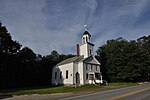
side of Royalsborough Road (Maine State Route 136), about 0.2 miles (0.32 km) west of its junction with Maine State Route 9. It is a single-story wood-frame...
3 KB (365 words) - 01:57, 26 May 2022

State Route 88 (SR 88) is a state highway in southern Maine, United States. It runs south to north for 8.37 miles (13.47 km), from U.S. Route 1 (US 1)...
5 KB (478 words) - 02:29, 26 March 2024

State Route 16 (SR 16) is a numbered state highway in Maine, United States. SR 16 runs from the New Hampshire state line (signed as NH-16) at Wentworth...
9 KB (295 words) - 01:03, 1 April 2024

Route 202 (US 202) is a spur route of US 2. It follows a northeasterly and southwesterly direction stretching from Delaware in the south to Maine in...
57 KB (3,240 words) - 03:48, 13 May 2024

State Route 3 (SR 3) is a 120.67-mile-long (194.20 km) state highway located in southern Maine. It is a major interregional highway, connecting the Interstate...
13 KB (773 words) - 19:39, 13 May 2024

Kentucky Route 136 (KY 136) is a 32.342-mile-long (52.049 km) state highway in northwestern Kentucky. It has two disconnected sections, one that goes from...
6 KB (396 words) - 17:50, 16 February 2024

State Route 125 (SR 125) is a north–south route in the U.S. State of Maine that runs between the towns of Freeport and Bowdoinham, passing through Lisbon...
4 KB (108 words) - 16:09, 12 November 2022

direct route between Portland and Augusta, the state capital, than its parent I-95. It also is toll-free, unlike I-95, which carries the tolled Maine Turnpike...
18 KB (1,171 words) - 09:23, 6 September 2023

State Route 17 (abbreviated SR 17) is part of Maine's system of numbered state highways, located in the south central part of the state. It is a major...
13 KB (608 words) - 02:14, 28 March 2023

State Route 135 (SR 135) is part of Maine's system of numbered state highways, located entirely within Kennebec County. It runs from SR 132 in Monmouth...
3 KB (107 words) - 05:09, 6 April 2023

north–south from Miami, Florida to Houlton, Maine. The highway enters Maine from the New Hampshire state line in Kittery and runs for 303 miles (488 km)...
37 KB (2,558 words) - 16:53, 28 April 2024

2009 Maine Press Association Newspaper of the Year. Interstate 95 US Route 202 State Route 11 State Route 4 State Route 121 State Route 136 State Route 122...
26 KB (2,361 words) - 04:09, 18 May 2024

Bagley-Bliss House (category Houses in Androscoggin County, Maine)
set on the east side of a rural stretch of Royalsborough Road (Maine State Route 136), just south of its junction with Quaker Meeting House Road and...
4 KB (429 words) - 17:17, 30 May 2022

Biddeford (/ˈbɪdɪfərd/ BID-ə-fərd) is a city in York County, Maine, United States. It is the principal commercial center of York County. Its population...
32 KB (3,002 words) - 04:17, 18 May 2024

Downeaster (train) (category Amtrak routes)
Passenger Rail Authority (NNEPRA), an agency of the state of Maine. Named for the Down East region of Maine, the train operates five daily round trips between...
57 KB (5,416 words) - 23:19, 22 May 2024

Penobscot Bay and the Gulf of Maine, part of the Atlantic Ocean. The town is crossed by U. S. Route 1 and state routes 17 and 90. It borders the towns...
15 KB (1,519 words) - 18:16, 17 March 2024
Traffic Control Devices-standard yellow-on-blue pentagon route marker. Even numbered routes are east–west roads that increase by multiples of four from...
30 KB (139 words) - 16:35, 9 February 2024

Vermont Route 9, NH 9, and Maine State Route 9, which connect Bennington, Vermont (and New York to the west) to as far east as Calais, Maine, although...
37 KB (3,355 words) - 13:01, 24 May 2024

Yarmouth is a town in Cumberland County, Maine, United States, twelve miles north of the state's largest city, Portland. When originally settled in 1636...
58 KB (6,219 words) - 17:19, 18 May 2024
called the Indian River Lagoon Scenic Highway from State Road 510 at Wabasso Beach to U.S. Route 1 in Cocoa. SR A1A is famous worldwide as a center of...
60 KB (2,488 words) - 16:34, 22 May 2024