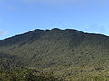
The Mainit Hot Springs Protected Landscape is a protected landscape area located in the province of Davao de Oro on the island of Mindanao in the Philippines...
6 KB (564 words) - 09:47, 11 January 2025

population of 84,340 people. The municipality is home to the Mainit Hot Springs Protected Landscape. The town of Nabunturan was once a barangay of Municipality...
19 KB (1,154 words) - 02:49, 3 January 2025

The Aliwagwag Protected Landscape is a protected area that preserves a major drainage catchment in the southern Philippine island of Mindanao in the Davao...
7 KB (728 words) - 17:04, 1 November 2024
Guadalupe Mabugnao Mainit Hot Spring National Park is a protected area of the Philippines located in Barangay Guadalupe in Carcar, Cebu, approximately...
4 KB (264 words) - 06:49, 19 April 2024

The Rajah Sikatuna Protected Landscape is a protected landscape area of forested limestone hills, grasslands and natural springs in the island province...
7 KB (655 words) - 00:59, 22 October 2024

The Central Cebu Protected Landscape (CCPL) is a protected area located in the mountains and drainage basins of central Cebu in the Philippines. The CCPL...
6 KB (451 words) - 13:16, 18 September 2024

(DENR) under the National Integrated Protected Areas System (NIPAS) Act of 1992. As of 2020, there are 244 protected areas in the Philippines, covering...
41 KB (639 words) - 20:54, 20 June 2025

Areas: Tiaong-San Pablo hot/warm springs Bakia warm/cold springs Sampaloc warm springs Mainit hot/warm springs Cagsiay hot/warm springs Banahaw is a custom...
13 KB (1,071 words) - 17:38, 25 June 2025

Pujada Bay (redirect from Pujada Bay Protected Landscape and Seascape)
declared a marine protected area known as the Pujada Bay Protected Landscape and Seascape. It covers 21,200 hectares (52,000 acres) protecting the bay and its...
5 KB (481 words) - 02:27, 20 February 2025
The Mati Protected Landscape is a protected area located in Davao Oriental on the southern Philippine island of Mindanao. It protects the watershed in...
4 KB (395 words) - 17:17, 30 October 2020

2021. Retrieved March 9, 2016. "Protected Areas in Region 11" Archived March 20, 2012, at the Wayback Machine. Protected Areas and Wildlife Bureau of the...
29 KB (2,581 words) - 08:57, 8 June 2025

The hills are separated by flat plains and contain numerous caves and springs. The origin of the conical karst of the Chocolate Hills is described on...
28 KB (2,730 words) - 05:31, 29 June 2025
The Baganga Protected Landscape, in Mindanao in the Philippines, is one of four protected watershed areas of the province of Davao Oriental. It covers...
3 KB (192 words) - 01:13, 2 October 2023
Mabini Protected Landscape and Seascape, in Davao de Oro, Philippines, is a terrestrial and marine protected area established in 2000 to protect ecologically...
6 KB (460 words) - 02:18, 20 February 2025

Tañon Strait (category Protected seascapes of the Philippines)
AND NEGROS ORIENTAL AS A PROTECTED AREA PURSUANT TO RA 7586 (NIPAS ACT OF 1992) AND SHALL BE KNOWN AS TAÑON STRAIT PROTECTED SEASCAPE, Official Gazette...
8 KB (735 words) - 09:30, 21 May 2025

and Nepenthes micramphora, are endemic to the area. The mountain has a protected forest area of approximately 2,000 hectares. This woodland is noted for...
13 KB (1,005 words) - 07:08, 2 February 2025

t e Protected areas in Central Visayas National parks Guadalupe Mabugnao Mainit Hot Spring Natural monuments Chocolate Hills Protected landscapes Central...
6 KB (368 words) - 02:05, 22 December 2024
Cordillera Central (Luzon) (section Protected areas)
Barangay Mainit, Bontoc, on the western slope of the mountain. Mount Santo Tomas, 2,252-metre (7,388 ft) high in Tuba, Benguet near Baguio, has Asin Hot Springs...
22 KB (2,448 words) - 19:20, 30 March 2025

Elementary School Tourist spots: Floating Cottage Balite Hot Spring (locally called "Mainit") Punta (Poo Island) Sandbar, Poo Kinablangan Mahan-ub is...
18 KB (1,265 words) - 06:42, 3 January 2025

68 sq mi), it is the third largest lake in Mindanao, after Lake Lanao and Lake Mainit. It has an average elevation of 4.5 metres (15 ft). The lake is sandwiched...
7 KB (425 words) - 09:38, 15 October 2024

Bantayan Island (section National protected areas)
legislation giving protected status. In 1981 President Marcos signed proclamation no. 2151 giving certain parts of the country protected status. This included...
81 KB (7,665 words) - 19:36, 2 June 2025

Among the lakes in the region, Lake Mainit is the widest. It traverses eight municipalities: Alegria, Tubod, Mainit and Sison in Surigao del Norte, and...
64 KB (6,715 words) - 12:30, 21 June 2025

climate) by Köppen–Geiger climate classification system. The area is relatively hot and humid, with a mean daily temperature range of 23.2 to 33.1 °C (73.8 to...
20 KB (1,962 words) - 02:24, 20 February 2025

Panglao Island (category Protected seascapes of the Philippines)
The Panglao Island Protected Seascape was declared a national park under Republic Act No. 11038 (Expanded National Integrated Protected Areas System Act...
8 KB (710 words) - 13:29, 29 March 2025

and became the island of Camiguin; a crater was left, which became Lake Mainit Pikit Octopus: a small octopus at the Pikit river who was raised by the...
283 KB (37,397 words) - 20:38, 28 June 2025