
Manunui (Māori: Mananui) is a small Whanganui River settlement, about 6 kilometres (3.7 mi) east of Taumarunui on State Highway 4, in New Zealand's King...
6 KB (418 words) - 12:59, 13 January 2025

Georgina te Heuheu (redirect from Georgina Manunui Te Heuheu)
Dame Georgina Manunui te Heuheu DNZM QSO (née Manunui, born 1943) is a New Zealand National Party politician. She was a Member of Parliament (MP) between...
11 KB (646 words) - 00:11, 12 March 2025

Manunui station was on the North Island Main Trunk line, in the Ruapehu District of New Zealand, serving Manunui. It was 2.9 km (1.8 mi) south east of...
7 KB (622 words) - 18:41, 8 September 2024

Ngāi Tūhoe (redirect from Ngāti Manunui (Tūhoe))
Ngāi Tūhoe (Māori pronunciation: [ˈŋaːi ˈtʉːhɔɛ]), often known simply as Tūhoe, is a Māori iwi (tribe) of New Zealand. It takes its name from an ancestral...
21 KB (2,482 words) - 02:59, 29 March 2025
934694; 175.382746 Piriaka Taumarunui County Near Manunui Yes [ Manunui Taumarunui Borough Manunui No National Park ? 1 July 1925 No Hokowhitu Palmerston...
4 KB (153 words) - 18:20, 22 July 2025

"Cave drawing of a moa". Te Ara Encyclopedia of New Zealand. Te Ara. "Te Manunui Rock Art Site". Heritage New Zealand. Owen, R. (1879) Hutton, F.W. & Coughtrey...
78 KB (8,286 words) - 19:12, 15 July 2025

Ngāti Tūwharetoa (redirect from Ngāti Manunui)
Ngāti Tūwharetoa is an iwi descended from Ngātoro-i-rangi, the priest who navigated the Arawa canoe to New Zealand. The Tūwharetoa region extends from...
14 KB (1,748 words) - 00:03, 4 February 2025

Ellis and Burnand (section Manunui)
which helped him acquire timber rights over large areas of bush near Manunui, Otorohanga and Mangapehi, so that he focussed on the timber trade and...
37 KB (3,646 words) - 21:11, 17 July 2025
Pukawa (redirect from Manunui a Ruakapanga)
It is home of the Ngāti Tūwharetoa hapū of Ngāti Manunui, who established the Pūkawa Marae and Manunui a Ruakapanga meeting house in November 2006. The...
15 KB (1,324 words) - 04:27, 15 May 2025

ever since." On State Highway 4 south of Taumarunui are the villages of Manunui, Piriaka, Kakahi, Ōwhango, Raurimu and then National Park. To the north...
49 KB (4,184 words) - 07:01, 1 June 2025
Hira) Taringamotu Kākāhi Marae Taumaihiorongo Ngāti Tūwharetoa (Ngāti Manunui) Kākāhi Kauriki Te Ōhākī Ngāti Tūwharetoa (Ngāti Hinemihi, Ngāti Turumakina)...
15 KB (96 words) - 05:14, 3 July 2025
Valley). The original King Country Rugby Union was formed in 1905 by the Manunui, Matapuna, Oio and Kakahi rugby clubs. In 1907, the newly formed Taumarunui...
26 KB (1,031 words) - 23:41, 5 July 2025
he decided to undertake military expeditions, convincing his brothers Manunui and Meremere to accompany him on raids down the Waikato River. He would...
19 KB (2,618 words) - 12:01, 7 August 2024
a New Zealand state highway in the central North Island that runs from Manunui, just south of Taumarunui on SH 4 to Tūrangi just north of the Desert Road...
2 KB (179 words) - 20:00, 25 August 2024
Tūwharetoa (Ngāti Parekāwa) Kuratau Pūkawa Marae Manunui a Ruakapanga Ngāti Tūwharetoa (Ngāti Manunui) Pūkawa Te Rangiita Marae Te Rangiita Ngāti Tūwharetoa...
24 KB (88 words) - 11:02, 21 September 2024

begins Ruapehu District Taumarunui 70 43 SH 43 (Kururau Road) – Stratford Manunui 77 48 SH 41 – Tūrangi National Park 114 71 SH 47 – Tūrangi Tohunga Junction...
4 KB (294 words) - 19:58, 25 August 2024
"Ingoa". Te Kura o Manunui. Retrieved 5 June 2025. "Te Kura o Manunui". asc architects. Retrieved 5 June 2025. "Āheinga ako". Te Kura o Manunui. Retrieved 5...
10 KB (676 words) - 02:50, 5 June 2025

Umuroa marae and Te Poho-o-Parahaki meeting house, affiliated with Ngāti Manunui. Uwhiārae marae and Te Paena meeting house, affiliated with Ngāi Te Paena...
13 KB (948 words) - 02:16, 17 July 2025

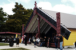
built in 1913, are a meeting place for the Ngāti Tūwharetoa hapū of Ngāti Manunui. A Catholic church, complete with a bell tower, stands on the edge of the...
13 KB (1,216 words) - 21:51, 8 November 2024
they captured Te Aratipi around 1820. The two commanders of the force, Manunui Te Heuheu II and Te Whakarau, each received one of them. The two pieces...
8 KB (1,077 words) - 00:33, 17 June 2025

time, long ago, The Main Trunk in a Day! or, more correctly, Puketutu to Manunui sometime in early 1972. Carolyn M. King, D. John Gaukrodger and Neville...
9 KB (1,090 words) - 17:48, 15 November 2024

swingbridge, and then follows the true right to the Belltown Manunui Hut. The route from Belltown Manunui Hut follows the true right of the Little Wanganui River...
29 KB (3,021 words) - 16:20, 27 July 2025

It was 5.27 km (3.27 mi) north of Kakahi and 4.63 km (2.88 mi) south of Manunui. It formally opened on 9 November 1908, though it was renamed from Pirihaka...
5 KB (349 words) - 18:38, 8 September 2024
Taumarunui, Manunui, and Rotorua where he was captain in a 29-2 defeat. Against Taumarunui they lost 10-5 on the Te Kūiti Domain. The match with Manunui in Taumarunui...
21 KB (2,128 words) - 13:06, 21 October 2024

Tāwhiao, helped John acquire timber rights over large areas of bush at Manunui, Ōtorohanga and Mangapehi, which influenced him to focus on the timber...
27 KB (2,653 words) - 03:55, 29 June 2025
with the wharenui Te Aroha o Ngā Mātua Tūpuna, which is shared with Ngāti Manunui, Petania Marae with the wharenui Hinemihi near Taringamotu, which is shared...
7 KB (753 words) - 02:51, 20 July 2025

who were under his sway on Motutaiko Island: Ngāti Te Rangiita, Ngāti Manunui, Ngāti Te Aho, Ngāti Hinewai, Ngāti Hukere, Ngāti Tūrū-makina, and Ngāti...
29 KB (3,669 words) - 19:26, 15 February 2025
Independent Town District within Waimate West County Mangaweka fl. 1952 3.86 km2 Manunui fl. 1952 Martinborough 1906 1928 Elevated to borough Marton 1869 1879 Elevated...
84 KB (2,496 words) - 09:48, 15 July 2025
Maniaiti Marae or Wallace Pā is a marae in Manunui, 8km south-east from the outskirts of Taumarunui, in the central North Island of New Zealand. Members...
5 KB (516 words) - 10:35, 28 June 2024
56111 • elevation 1,040 m (3,410 ft) Mouth Whanganui River • location Manunui • coordinates 38°53′28″S 175°20′00″E / 38.89099°S 175.33347°E / -38...
3 KB (64 words) - 15:45, 11 November 2024