Mesh blocks or meshblocks are a small geographic unit used in the census of several countries. New Zealand's countrywide meshblock framework was first...
6 KB (565 words) - 06:10, 27 July 2025
each individual meshblock (the smallest census unit, consisting of about 50 households each), disregarding any household in the meshblock that did not have...
16 KB (1,586 words) - 19:11, 18 June 2025
A census tract, census area, census district or meshblock is a geographic region defined for the purpose of taking a census. Sometimes these coincide...
18 KB (1,927 words) - 18:43, 21 May 2025

at meshblock level (2025 Meshblock). Retrieved 9 May 2025. "Geographic Boundary Viewer". Stats NZ. 2023 Census electoral population at meshblock level...
7 KB (489 words) - 02:39, 9 May 2025

is located close to the coast between Awakino and Kawhia Harbour. The meshblock includes the coastal township of Marokopa, at the mouth of the Marokopa...
14 KB (1,018 words) - 02:57, 9 May 2025

Stats NZ says". Stuff. Retrieved 5 February 2023. "ANZLIC Metadata 2018 Meshblock – GIS | | GIS Map Data Datafinder Geospatial Statistics | Stats NZ Geographic...
19 KB (1,989 words) - 03:33, 30 June 2025

2 October 2021. "Meshblock Electoral Populations 2020 for proposed boundaries data". Statistics New Zealand. April 2020. Meshblock 4007645. "Place name...
7 KB (574 words) - 06:57, 24 April 2025

2001 171 — 2006 108 −8.78% 2013 114 +0.78% 2018 150 +5.64% 2023 162 +1.55% Populations before 2013 are for the equivalent meshblock 0022000. Source:...
17 KB (1,637 words) - 01:27, 9 December 2024
electoral population at meshblock level (2025 Meshblock). Retrieved 9 May 2025. "Geographic Boundary Viewer". Stats NZ. Meshblock – 2025 and Statistical...
5 KB (271 words) - 01:35, 10 May 2025

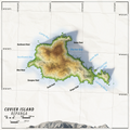
volcanoes in New Zealand List of islands Desert island "Population by meshblock (2013 Census)". Stats NZ. 11 December 2015. Retrieved 30 May 2018. "Kumaras...
6 KB (600 words) - 20:56, 30 May 2025

Geographic Data Service". 2023 Census electoral population at meshblock level (2025 Meshblock). Retrieved 28 March 2025. "827 Ruapuke Rd to Te Mata". Google...
11 KB (795 words) - 01:22, 28 March 2025

March 2020. "Meshblock Electoral Populations 2020 for proposed boundaries data". Statistics New Zealand. April 2020. 0861000. "Meshblock Electoral Populations...
13 KB (1,056 words) - 06:14, 23 July 2025
of islands of New Zealand List of islands Desert island "Population by meshblock (2013 Census)". Stats NZ. 11 Dec 2015. Retrieved 2018-05-30. "Data Table...
5 KB (397 words) - 11:03, 10 April 2024

Gallery. In the 2013 census, Tararu's population was 525, made up of 210 in meshblock 1048800, 138 (1048900), 48 (1048700), 39 (1049000) and 90 (1049100). Tararu...
13 KB (958 words) - 14:02, 18 February 2025
in Central Hawke's Bay in the east of the North Island of New Zealand. Meshblock 7016748, which covers 19.3 km2 (7.5 sq mi) from the edge of Waipukurau...
39 KB (3,477 words) - 14:41, 30 May 2025
Viewer". Stats NZ. Meshblock – 2023. "Stats NZ Geographic Data Service". 2023 Census electoral population at meshblock level (2025 Meshblock). Retrieved 12...
9 KB (709 words) - 02:50, 17 May 2025
meeting house are affiliated with Ngāti Mahuta and Ngāti Te Weehi. The meshblocks around the edge of the harbour had these census results - The population...
18 KB (1,477 words) - 10:17, 13 July 2025
activities at the end. "2013 Census map - Quickstats about a place - Meshblock 2804800". Statistics New Zealand. 2013. Archived from the original on...
6 KB (693 words) - 03:56, 15 March 2025
which data are available is a meshblock, and Barrhill is located within the meshblock with ID 2750400. This meshblock has an area of 36 square kilometres...
27 KB (2,473 words) - 02:01, 29 May 2025
of Weber, on Route 52, formerly State Highway 52. Ākitio is in three meshblocks, which had a combined population of 111 people in 48 households in the...
13 KB (1,172 words) - 08:08, 26 July 2025

located south of Te Kūiti and Waimiha, and north of Taumarunui. It is in meshblock 1041902, which had a population of 54 in 2013. The New Zealand Ministry...
4 KB (405 words) - 10:17, 8 November 2024
through the eastern part of the meshblock, beginning just after Bulls and continuing further into Pohonui-Porewa meshblock. The North Island portion of this...
14 KB (1,100 words) - 04:44, 4 November 2024
and landscape to create a series of ponds connected by a creek. In 2013 meshblock 0978002 had a population of 93 living in 33 houses. "IntraMaps". maps...
3 KB (149 words) - 03:21, 30 June 2023

hapū of Ngāti Rākei, Rungaterangi and Waiora. Awakino settlement is in meshblocks 1016500 and 1016900, which had a population of 69 people in the 2023 census...
20 KB (1,632 words) - 02:21, 9 May 2025
1% were European, 27.2% Asian and 13.7% Māori. Only 3 people lived in meshblock 0955300, at the Research Centre, in 2013. Tai Wananga is a co-educational...
24 KB (1,826 words) - 08:59, 3 July 2025

Geographic Data Service". 2023 Census electoral population at meshblock level (2025 Meshblock) (Meshblock 4014679). Retrieved 5 April 2025. "PostShop/Kiwibank...
27 KB (2,396 words) - 00:54, 12 June 2025

of islands of New Zealand List of islands Desert island "Population by meshblock (2013 Census)". Stats NZ. 11 December 2015. Retrieved 30 May 2018. "Pigeon...
3 KB (165 words) - 11:04, 10 April 2024
for cooking" (ahi) "muttonbirds" (titi). Ahititi and its surrounds in Meshblock 1552600 had a population of 84 people in 33 households in the 2013 New...
4 KB (339 words) - 03:19, 17 October 2024

1926. At the 2018 New Zealand census Rissington had 195 living in its meshblock, 1412300, which covers 87.96 km2 (33.96 sq mi). A cartage service began...
21 KB (1,863 words) - 07:00, 24 November 2024
Dracophyllum strictum, grows extensively in the area. Waikawau is astride meshblocks 1016301 and 1016400, which had a population of 51 people in the 2023 census...
7 KB (446 words) - 02:21, 9 May 2025