
3D light microscopes ("MountainsMap"), scanning electron microscopes ("MountainsSEM") and scanning probe microscopes ("MountainsSPIP"). The main editor's...
17 KB (1,210 words) - 14:30, 2 June 2025
manufacturers under their own brands are products tailored from MountainsMap, MountainsSEM or MountainsSPIP. Digital Surf technology on Olympus Microscopes in...
8 KB (703 words) - 16:31, 12 October 2024
parameters defined in ISO 25178, such as MountainsMap from Digital Surf, SPIP from Image Metrology [2], TrueMap 6 from TrueGage [3], as well as the open...
11 KB (1,293 words) - 13:38, 5 November 2024
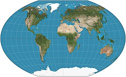
features. Political maps emphasize territorial boundaries and human settlement. Physical maps show geographical features such as mountains, soil type, or land...
9 KB (897 words) - 04:23, 3 June 2025
(disambiguation) All pages with titles containing mountain All pages with titles containing mountains MountainsMap, micro-topography software published by Digital...
4 KB (482 words) - 21:28, 29 March 2025

Cadastral map Climatic map Geological map Historical map Linguistic map Nautical map Physical map Political map Relief map Resource map Road map Star map Street...
36 KB (4,374 words) - 22:55, 2 June 2025
Google Maps is a web mapping platform and consumer application offered by Google. It offers satellite imagery, aerial photography, street maps, 360° interactive...
163 KB (14,187 words) - 22:04, 31 May 2025
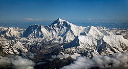
973 m (22,877 ft) to 6,987 m (22,923 ft). Some mountains differ by more than 100 m (330 ft) on different maps, while even very thorough current measurements...
57 KB (2,208 words) - 05:57, 26 May 2025

The Hudson Mountains are a mountain range in western Ellsworth Land just east of Pine Island Bay at the Walgreen Coast of the Amundsen Sea. They are of...
34 KB (4,586 words) - 02:41, 2 June 2025
Tucker Glacier (category Admiralty Mountains)
Glacier draining south from the Admiralty Mountains and entering upper Tucker Glacier just east of Homerun Range. Mapped by the United States Geological Survey...
25 KB (4,213 words) - 14:05, 11 March 2024

The Sacred Mountains of China are divided into several groups. The Five Great Mountains (simplified Chinese: 五岳; traditional Chinese: 五嶽; pinyin: Wǔyuè)...
24 KB (2,823 words) - 14:46, 2 April 2025

Bern, Graubünden, Uri, and Glarus. All mountain heights and prominences on the list are from the largest-scale maps available. Summits with a prominence...
61 KB (479 words) - 05:39, 6 July 2024

Club maps (German: Alpenvereinskarten, often abbreviated to AV-Karten i.e. AV maps) are especially detailed maps for summer and winter mountain climbers...
2 KB (296 words) - 20:20, 26 October 2024

to 5.8 mi) wide, that forms a western extension of Toney Mountain in Marie Byrd Land. Mapped by the United States Geological Survey (USGS) from ground...
17 KB (2,491 words) - 00:34, 28 May 2025

Claude Lorius, and Arnold Heine of that traverse team. The mountains were completely mapped by the United States Geological Survey from VLT reports, U...
12 KB (1,314 words) - 10:42, 3 June 2025
8.1 mi) northeast of the Behrendt Mountains in Ellsworth Land, Antarctica. Map all coordinates using OpenStreetMap Download coordinates as: KML GPX (all...
5 KB (798 words) - 11:57, 23 April 2024
OpenStreetMap (abbreviated OSM) is a free, open map database updated and maintained by a community of volunteers via open collaboration. Contributors...
111 KB (10,646 words) - 16:06, 2 June 2025
(56 km; 35 mi) south of the Sweeney Mountains in eastern Ellsworth Land, Antarctica. Map all coordinates using OpenStreetMap Download coordinates as: KML GPX...
10 KB (1,646 words) - 18:27, 30 September 2024
blue lines for rivers, red lines for mountain ranges etc. The world is shown as encircled by the ocean. The map is now kept at the Pera Museum in Istanbul...
73 KB (8,596 words) - 22:27, 18 May 2025
The Playfair Mountains were first seen and photographed from the air by the United States Antarctic Service (USAS), 1939–41. They were mapped by the United...
5 KB (744 words) - 13:04, 25 April 2024

Pictorial maps (also known as illustrated maps, panoramic maps, perspective maps, bird's-eye view maps, and geopictorial maps) depict a given territory...
13 KB (1,602 words) - 21:06, 4 April 2025

The Rocky Mountains, also known as the Rockies, are a major mountain range and the largest mountain system in North America. The Rocky Mountains stretch...
55 KB (5,494 words) - 00:24, 4 June 2025

Information New Zealand (LINZ) Topo50 topographic maps at the interactive topographic map of New Zealand site. Mountains are referred to as maunga in the Māori language...
62 KB (2,587 words) - 22:14, 23 May 2025

The Transantarctic Mountains (abbreviated TAM) comprise a mountain range of uplifted rock (primarily sedimentary) in Antarctica which extends, with some...
13 KB (1,326 words) - 14:37, 13 June 2024
Daallo Mountain (Somali: Buuraha Daalo) is a national park in the eastern Sanaag region of Somaliland. It is a part of the Ogo Mountains. Daallo has historically...
3 KB (234 words) - 07:51, 14 March 2025
(looking south-west)" (Map). Google Maps. Retrieved 30 January 2022. "Top of Black Mountain (looking north)" (Map). Google Maps. Retrieved 30 January 2022...
12 KB (971 words) - 03:31, 4 January 2025
Daniels Range (category Mountain ranges of Oates Land)
Daniels Range between Thompson Spur and Schroeder Spur, in the Usarp Mountains. Mapped by USGS from surveys and U.S. Navy air photos, 1960-63. Named by US-ACAN...
18 KB (2,491 words) - 16:14, 20 September 2024

to the mountains themselves. The first cartographic appearance of Apalchen is on Diego Gutiérrez's map of 1562; the first use for the mountain range is...
85 KB (9,197 words) - 00:10, 8 May 2025
Society. They are south of the Cook Mountains and north of the Britannia Range Map all coordinates using OpenStreetMap Download coordinates as: KML GPX (all...
9 KB (1,516 words) - 12:30, 13 March 2024
Map all coordinates using OpenStreetMap Download coordinates as: KML GPX (all coordinates) GPX (primary coordinates) GPX (secondary coordinates) A sortable...
61 KB (174 words) - 11:41, 15 March 2025