The Mulwaree River, a perennial river that is part of the Hawkesbury-Nepean catchment, is located in the Southern Tablelands region of New South Wales...
5 KB (242 words) - 23:38, 10 April 2024

joined by the Mulwaree River. At Towrang the river turns north-east to a point near Bullio, where it is joined by the Wingecarribee River. From here the...
7 KB (399 words) - 21:27, 6 May 2022

a population of 24,565 at June 2021. Goulburn is the seat of Goulburn Mulwaree Council. Goulburn is a railhead on the Main Southern line, and regional...
44 KB (4,963 words) - 00:26, 9 May 2024
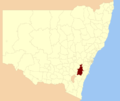
Goulburn Mulwaree Council is a local government area located in the Southern Tablelands region of New South Wales, Australia. The area is located adjacent...
8 KB (690 words) - 07:28, 29 December 2023
carries the Main Southern railway line across the Mulwaree River at Goulburn, in the Goulburn Mulwaree Council local government area of New South Wales...
11 KB (1,113 words) - 05:23, 27 April 2023
This page discusses the rivers and hydrography of the state of New South Wales, Australia. The principal topographic feature of New South Wales is the...
21 KB (546 words) - 16:43, 19 December 2023

Mooney Mooney Mooki Mooni Moppy Moredun Moruya Mowamba Mulga Mulla Mulla Mulwaree Mummel Munmurra Murrah Murray Murruin Murrumbidgee Myall N Nadgee Nadgigomar...
55 KB (2,240 words) - 00:29, 3 January 2024

Parish of Merigan (category Goulburn Mulwaree Council)
civil parish of Murray County, New South Wales. The parish is on the Mulwaree River a few miles south of Tarago. It lies on the Bombala railway line and...
1 KB (126 words) - 00:28, 28 January 2024

The Parish of Mulwaree is a parish of Argyle County. It is located on the western shore of Lake Bathurst, New South Wales. The area was traditional lands...
4 KB (384 words) - 22:08, 21 November 2020
Thornes Bridge (category Goulburn Mulwaree Council)
Thornes Bridge was a timber Allan truss-type bridge that spanned the Mulwaree River between Goulburn and Brisbane Grove in New South Wales, Australia. It...
3 KB (182 words) - 00:23, 30 April 2024
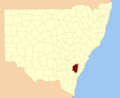
Mulwaree Shire was a local government area in the Southern Tablelands region of New South Wales, Australia. Mulwaree Shire was proclaimed on 7 March 1906...
3 KB (210 words) - 02:33, 13 July 2023
Georges River Council is a local government area located in the St George region of Sydney located south of the Sydney CBD, in New South Wales, Australia...
33 KB (2,637 words) - 07:19, 26 March 2024

Tallong, New South Wales (category Goulburn Mulwaree Council)
the Southern Highlands region of New South Wales, Australia, in Goulburn-Mulwaree Council. At the 2021 census, the village had a population of 914. The town...
9 KB (804 words) - 00:12, 22 May 2024
"Forbes". ABC News. "Georges River". ABC News. "Gilgandra". ABC News. "Glen Innes Severn Shire". ABC News. "Goulburn Mulwaree". ABC News. "Greater Hume Shire"...
299 KB (1,313 words) - 01:56, 17 May 2024

were ‘Wollondilly’, ‘Mulwaree’, ‘Guineacor’, ‘Bullio’, ‘Kooringa’ and ‘Miranda’ caves. The first three are the names of local rivers and Bullio is a nearby...
8 KB (821 words) - 01:50, 31 January 2024
amalgamation of the former City of Goulburn and parts of Mulwaree Shire. It was renamed the Goulburn Mulwaree Council in October 2004. A full list of parishes...
13 KB (465 words) - 18:27, 4 May 2023

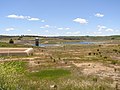
municipal water supply system and now museum at Wollondilly River, Goulburn, Goulburn Mulwaree Council, New South Wales, Australia. It was built from 1885...
9 KB (990 words) - 13:32, 8 December 2023

Parish of Marulan is a parish of Argyle County located with the Goulburn Mulwaree local government area, which includes the towns of Marulan and Marulan...
3 KB (228 words) - 19:47, 19 March 2022

List of Australian place names of Aboriginal origin (section Regions and shires not named after town, river, etc.)
Shire Gannawarra Shire Illawarra Ku-ring-gai Municipality Moorabool Shire Mulwaree Shire (abolished) Murrumbidgee Murrundindi Shire Ngaanyatjarraku Nillumbik...
56 KB (1,989 words) - 02:16, 11 May 2024

Goulburn, in Goulburn Mulwaree Council at 34°42′54″S, 149°38′04″E. A village of Baw Baw was surveyed on the banks of the Wollondilly River, but was never constructed...
3 KB (199 words) - 07:46, 21 August 2022

Park is a heritage-listed homestead at Bungonia Road, Goulburn, Goulburn Mulwaree Council, New South Wales, Australia. It was built from 1822 to 1825. It...
14 KB (1,800 words) - 13:18, 8 December 2023

The Snowy River Shire was a local government area in the Australian Alps region of New South Wales, Australia from 1939 until May 2016. It was named after...
8 KB (587 words) - 16:24, 29 April 2023
Hill NSWCCC 2007 Lachlan Coote Windsor High NSWCHS 2007 Jarrod Croker Mulwaree High, NSWCHS 2007 Kieran Foran Marist Catholic College, North Shore NSWCCC...
76 KB (110 words) - 18:33, 31 March 2024

Sutherland Shire (category Georges River)
Geographically, it is the area to the south of Botany Bay and the Georges River. The Sutherland Shire is 26 kilometres (16 mi) south of Sydney central business...
59 KB (5,113 words) - 09:39, 24 May 2024
Richmond River High Campus, part of The Rivers Secondary College, is a dual-campus government-funded co-educational comprehensive secondary day school...
5 KB (232 words) - 19:13, 18 May 2024

The Shire was formed in February 2004 from Crookwell Shire and parts of Mulwaree, Gunning and Yass Shires. The mayor of Upper Lachlan Shire Council is Cr...
8 KB (521 words) - 00:44, 16 September 2023
7 July 2017. Australian Bureau of Statistics (27 June 2017). "Goulburn Mulwaree (A)". 2016 Census QuickStats. Retrieved 7 July 2017. Australian Bureau...
52 KB (2,825 words) - 06:34, 13 April 2024
Southern Highlands of New South Wales, Australia. It is in the Goulburn Mulwaree Council local government area and the traditional lands of the Gundungurra...
7 KB (677 words) - 12:47, 20 April 2024

the Shoalhaven River. The Jerrinja people record their traditional lands as stretching from Crooked River in the north to Clyde River in the south, from...
15 KB (861 words) - 21:07, 14 May 2024
December 2013. Retrieved 11 March 2014. "Water management". Water. Goulburn Mulwaree Council. Retrieved 11 March 2014. Hodgkinson, Katrina (12 January 2012)...
10 KB (984 words) - 05:24, 23 September 2023