
Newfoundland and Labrador. Its southern terminus is at Route 90 in St. Vincent's-St. Stephen's-Peter's River, and its northern terminus is at Route 2...
7 KB (338 words) - 23:27, 14 February 2024
This is a list of highways in Newfoundland and Labrador. Newfoundland and Labrador is unusual among jurisdictions in Canada in that it exclusively uses...
39 KB (2,795 words) - 03:06, 2 March 2024

The Trans-Labrador Highway (TLH) is the primary public road in Labrador, the mainland portion of the province of Newfoundland and Labrador, Canada. The...
25 KB (1,536 words) - 11:01, 17 February 2025
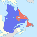
The border between the province of Newfoundland and Labrador and the province of Quebec is the longest interprovincial border in Canada. It stretches...
59 KB (6,527 words) - 20:26, 12 May 2025

in the Canadian province of Newfoundland and Labrador. It connects the town of Burgeo with the Trans-Canada Highway (Route 1). The highway is a winding...
4 KB (286 words) - 16:35, 18 April 2023
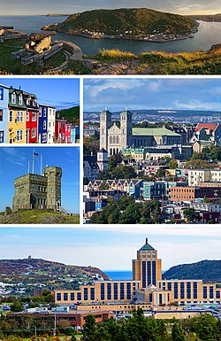
St. John's is the capital and largest city of the Canadian province of Newfoundland and Labrador. It is located on the eastern tip of the Avalon Peninsula...
160 KB (13,404 words) - 11:29, 29 April 2025
Party of Newfoundland and Labrador is a provincial political party in Newfoundland and Labrador, Canada. The party was founded in 1949 and most recently...
100 KB (9,709 words) - 00:44, 2 May 2025

Labrador (/ˈlæbrədɔːr/) is a geographic and cultural region within the Canadian province of Newfoundland and Labrador. It is the primarily continental...
64 KB (5,852 words) - 11:26, 8 May 2025

Canadian province of Newfoundland and Labrador. The route begins at the intersection of Route 1 (The Trans Canada Highway) in Deer Lake and ends in St. Anthony...
14 KB (825 words) - 18:21, 5 April 2024

Route 20 is a 30.2-kilometre-long (18.8 mi) provincial highway in Newfoundland and Labrador, extending from St. John's to the towns of Torbay, Flatrock...
6 KB (302 words) - 21:23, 31 January 2025

from Goobies to Grand Bank, Newfoundland and Labrador. The maximum speed limit is 90 km/h except through communities and settlements where the speed limit...
15 KB (719 words) - 15:08, 22 October 2022

province of Newfoundland and Labrador. The road provides a direct link from the Trans-Canada Highway (TCH) to downtown St. John's, Newfoundland, which was...
10 KB (653 words) - 22:11, 30 August 2024
Canadian province of Newfoundland and Labrador. St. Anthony serves as a main service centre for northern Newfoundland and southern Labrador. St. Anthony had...
23 KB (1,626 words) - 00:46, 15 April 2025

of Newfoundland and Labrador. Its eastern terminus is the intersection at the Trans-Canada Highway (Route 1) in the Town of Badger, and the route ends...
4 KB (312 words) - 01:44, 16 July 2024
St. Shott's (redirect from Newfoundland and Labrador Route 10-52)
Newfoundland and Labrador. In the Canada 2021 Census, the town had a population of 55. St. Shott's is accessible by road via St. Shott's Road (Route 10–52)...
9 KB (414 words) - 12:37, 29 March 2025
Labrador City is a town in western Labrador (part of the Canadian province of Newfoundland and Labrador), near the Quebec border. With a population of...
22 KB (1,077 words) - 23:33, 29 April 2025

Newfoundland and Labrador is the easternmost province of Canada, in the country's Atlantic region. The province comprises the island of Newfoundland and...
199 KB (18,976 words) - 11:44, 13 May 2025

on the Bonavista Peninsula, Newfoundland in the Canadian province of Newfoundland and Labrador. Unlike many Newfoundland coastal settlements, Bonavista...
21 KB (1,181 words) - 01:38, 4 April 2025
Route 1 is a highway in the Canada province of Newfoundland and Labrador, and is the easternmost stretch of the Trans-Canada Highway. Route 1 is the primary...
32 KB (1,175 words) - 00:58, 24 December 2024
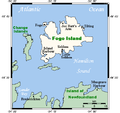
largest of the offshore islands of Newfoundland and Labrador, Canada. It lies off the northeast coast of Newfoundland, northwest of Musgrave Harbour across...
15 KB (1,669 words) - 13:39, 13 March 2025

Canadian province of Newfoundland and Labrador. It connects the towns of Charlottetown and Pinsent's Arm with the Trans-Labrador Highway (Route 510). The road...
3 KB (171 words) - 19:16, 27 April 2025

Avalon Peninsula of Newfoundland in the Canadian province of Newfoundland and Labrador. Its southern terminus is at Route 10 in Goulds and its northern terminus...
4 KB (295 words) - 01:44, 16 July 2024

of Newfoundland and Labrador's mainland Labrador region with the island of Newfoundland. This strait has a minimum width of 17.4 km (9.4 nmi; 10.8 mi)...
11 KB (1,179 words) - 14:18, 6 March 2025

communities include Norris Point and Neddie's Harbour. Rocky Harbour has two exits from Newfoundland and Labrador Route 431. In the 2021 Census of Population...
8 KB (383 words) - 00:03, 25 August 2024

northernmost permanent settlement in the Canadian province of Newfoundland and Labrador, within the Nunatsiavut region, located about 370 km (230 mi)...
33 KB (1,950 words) - 23:44, 29 April 2025

Route 360, also known as Bay d'Espoir Highway, is a provincial highway in Newfoundland and Labrador. It runs from the Bishop's Falls area to Bay d'Espoir...
7 KB (426 words) - 01:44, 16 July 2024

Route 213 is a highway on the Burin Peninsula of the island of Newfoundland in the Canadian province of Newfoundland and Labrador. It is one of a small...
3 KB (189 words) - 15:10, 22 October 2022
Canadian province of Newfoundland and Labrador. It serves to connect the towns of Torbay and Bauline. The naming of transit routes leading to a specific...
4 KB (316 words) - 09:00, 27 November 2024
BR-010 Route 10 Alberta Highway 10 British Columbia Highway 10 Manitoba Highway 10 New Brunswick Route 10 Newfoundland and Labrador Route 10 Northwest...
11 KB (729 words) - 18:34, 17 February 2025

Route 335, also known as Farewell Road, is a highway in the northern portion of Newfoundland in the Canadian province of Newfoundland and Labrador. The...
3 KB (176 words) - 15:22, 22 October 2022