Canadian province of Newfoundland and Labrador. It serves to connect the towns of Torbay and Bauline. The naming of transit routes leading to a specific...
4 KB (316 words) - 11:04, 28 May 2025
This is a list of highways in Newfoundland and Labrador. Newfoundland and Labrador is unusual among jurisdictions in Canada in that it exclusively uses...
39 KB (2,795 words) - 03:06, 2 March 2024

of Newfoundland and Labrador. Its eastern terminus is the intersection at the Trans-Canada Highway (Route 1) in the Town of Badger, and the route ends...
4 KB (312 words) - 01:44, 16 July 2024
is a town on the Avalon Peninsula in Newfoundland and Labrador, Canada in Division 1. Whitbourne, Newfoundland's first inland town, is named after Sir...
8 KB (498 words) - 02:35, 28 January 2023

The Trans-Labrador Highway (TLH) is the primary public road in Labrador, the mainland portion of the province of Newfoundland and Labrador, Canada. The...
25 KB (1,536 words) - 11:01, 17 February 2025
Route 1 is a highway in the Canada province of Newfoundland and Labrador, and is the easternmost stretch of the Trans-Canada Highway. Route 1 is the primary...
32 KB (1,175 words) - 00:58, 24 December 2024
Labrador City is a town in western Labrador (part of the Canadian province of Newfoundland and Labrador), near the Quebec border. With a population of...
22 KB (1,077 words) - 23:33, 29 April 2025
St. John's is the capital and largest city of the Canadian province of Newfoundland and Labrador. It is located on the eastern tip of the Avalon Peninsula...
160 KB (13,416 words) - 21:35, 26 June 2025

Route 201 (known as the Osprey Trail) is a provincial road in the Canadian province of Newfoundland and Labrador. It is one of only three loop roads designated...
4 KB (288 words) - 01:44, 16 July 2024

northernmost permanent settlement in the Canadian province of Newfoundland and Labrador, within the Nunatsiavut region, located about 370 km (230 mi)...
34 KB (1,981 words) - 20:40, 19 June 2025
Party of Newfoundland and Labrador is a provincial political party in Newfoundland and Labrador, Canada. The party was founded in 1949 and most recently...
100 KB (9,730 words) - 22:48, 23 June 2025

Route 2, also known as Pitts Memorial Drive and Peacekeeper's Way, is a 34.2-kilometre-long (21.3 mi) freeway on the Avalon Peninsula of Newfoundland...
10 KB (653 words) - 22:11, 30 August 2024

Route 20 is a 30.2-kilometre-long (18.8 mi) provincial highway in Newfoundland and Labrador, extending from St. John's to the towns of Torbay, Flatrock...
6 KB (302 words) - 21:23, 31 January 2025

in the Canadian province of Newfoundland and Labrador. It connects the town of Burgeo with the Trans-Canada Highway (Route 1). The highway is a winding...
4 KB (286 words) - 16:35, 18 April 2023

Canadian province of Newfoundland and Labrador. The route begins at the intersection of Route 1 (The Trans Canada Highway) in Deer Lake and ends in St. Anthony...
14 KB (825 words) - 18:21, 5 April 2024

from Goobies to Grand Bank, Newfoundland and Labrador. The maximum speed limit is 90 km/h except through communities and settlements where the speed limit...
15 KB (719 words) - 15:08, 22 October 2022

Isle, connecting the province of Newfoundland and Labrador's mainland Labrador region with the island of Newfoundland. This strait has a minimum width...
11 KB (1,179 words) - 14:18, 6 March 2025

Route 360, also known as Bay d'Espoir Highway, is a provincial highway in Newfoundland and Labrador. It runs from the Bishop's Falls area to Bay d'Espoir...
7 KB (426 words) - 01:44, 16 July 2024
Bell Island is an island that is part of Newfoundland and Labrador, Canada's easternmost province. With an area of 34 square kilometres (13 sq mi), it...
127 KB (15,376 words) - 23:43, 5 June 2025

Labrador (/ˈlæbrədɔːr/) is a geographic and cultural region within the Canadian province of Newfoundland and Labrador. It is the primarily continental...
64 KB (5,850 words) - 16:13, 23 June 2025

Route 406, also known as Codroy Road, is a highway on the western portion of Newfoundland in the Canadian province of Newfoundland and Labrador. It is...
4 KB (217 words) - 01:44, 16 July 2024
Canadian province of Newfoundland and Labrador. St. Anthony serves as a main service centre for northern Newfoundland and southern Labrador. St. Anthony had...
23 KB (1,651 words) - 15:36, 24 June 2025

Route 422, also known as Cormack Road, is a relatively short highway on western Newfoundland in the Canadian province of Newfoundland and Labrador. The...
3 KB (199 words) - 18:21, 5 April 2024

town and designated place in the Canadian province of Newfoundland and Labrador. Located in the northeastern portion of the island of Newfoundland on Freshwater...
7 KB (427 words) - 19:33, 16 February 2025

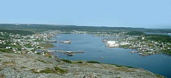
Grey River is a local service district and designated place in the Canadian province of Newfoundland and Labrador. Grey River was first settled in the early...
12 KB (994 words) - 02:18, 24 May 2025

Route 390, also known as Springdale Road, is a highway in the central portion of Newfoundland in the Canadian province of Newfoundland and Labrador. It...
3 KB (194 words) - 01:44, 16 July 2024

the Canadian province of Newfoundland and Labrador. The highway begins at a junction with Route 1 (Trans-Canada Highway) and continues to its west terminus...
3 KB (186 words) - 15:42, 22 October 2022
north-central Newfoundland, Newfoundland and Labrador, Canada on the Exploits River. It supplied pulp and paper for the mills in Grand Falls for many years and was...
15 KB (1,266 words) - 21:27, 18 December 2024
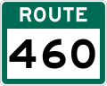
Route 460 is an 87.5-kilometre-long (54.4 mi) east-west Canadian provincial highway in Newfoundland and Labrador. It is located on the west coast of the...
9 KB (612 words) - 15:35, 15 July 2024

Newfoundland and Labrador. It leads from Sheppardville, at Route 1 (Trans-Canada Highway), to a dead end in Fleur de Lys, Newfoundland and Labrador....
5 KB (314 words) - 03:31, 24 May 2025