Route 310, also known as Road to the Beaches, in Newfoundland and Labrador runs from its southern terminus at Glovertown, and ends at its northern terminus...
6 KB (366 words) - 18:32, 15 September 2024
This is a list of highways in Newfoundland and Labrador. Newfoundland and Labrador is unusual among jurisdictions in Canada in that it exclusively uses...
39 KB (2,795 words) - 03:06, 2 March 2024

The Trans-Labrador Highway (TLH) is the primary public road in Labrador, the mainland portion of the province of Newfoundland and Labrador, Canada. The...
25 KB (1,536 words) - 11:01, 17 February 2025
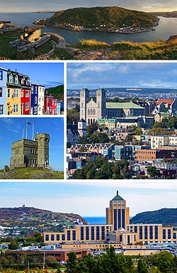
St. John's is the capital and largest city of the Canadian province of Newfoundland and Labrador. It is located on the eastern tip of the Avalon Peninsula...
160 KB (13,404 words) - 11:29, 29 April 2025

of Newfoundland and Labrador. Its eastern terminus is the intersection at the Trans-Canada Highway (Route 1) in the Town of Badger, and the route ends...
4 KB (312 words) - 01:44, 16 July 2024

in the Canadian province of Newfoundland and Labrador. It connects the town of Burgeo with the Trans-Canada Highway (Route 1). The highway is a winding...
4 KB (286 words) - 16:35, 18 April 2023
in the northeastern part of the island of Newfoundland in the Canadian province of Newfoundland and Labrador, approximately 40 km (25 mi) south of Gander...
36 KB (2,690 words) - 20:28, 9 May 2025

Route 201 (known as the Osprey Trail) is a provincial road in the Canadian province of Newfoundland and Labrador. It is one of only three loop roads designated...
4 KB (288 words) - 01:44, 16 July 2024

Cove-St. Philips in Newfoundland and Labrador, Canada. Route 40 also serves as the primary access to St. John's International Airport and the Bell Island...
4 KB (271 words) - 21:09, 30 August 2024

Route 403 is a minor highway in the western region of Newfoundland in the Canadian province of Newfoundland and Labrador. The highway begins at a junction...
2 KB (134 words) - 01:45, 16 July 2024

Canadian province of Newfoundland and Labrador. The route begins at the intersection of Route 1 (The Trans Canada Highway) in Deer Lake and ends in St. Anthony...
14 KB (825 words) - 18:21, 5 April 2024
Route 1 is a highway in the Canada province of Newfoundland and Labrador, and is the easternmost stretch of the Trans-Canada Highway. Route 1 is the primary...
32 KB (1,175 words) - 00:58, 24 December 2024

Avalon Peninsula of Newfoundland in the Canadian province of Newfoundland and Labrador. Its southern terminus is at Route 10 in Goulds and its northern terminus...
4 KB (295 words) - 01:44, 16 July 2024

Route 20 is a 30.2-kilometre-long (18.8 mi) provincial highway in Newfoundland and Labrador, extending from St. John's to the towns of Torbay, Flatrock...
6 KB (302 words) - 21:23, 31 January 2025

the Avalon Peninsula of Newfoundland. The highway also carries the designation of Baccalieu Trail for its entire length. Route 70 begins in Roaches Line...
9 KB (348 words) - 01:43, 16 July 2024

Route 335, also known as Farewell Road, is a highway in the northern portion of Newfoundland in the Canadian province of Newfoundland and Labrador. The...
3 KB (176 words) - 15:22, 22 October 2022

of Newfoundland and Labrador. It connects the town of Cartwright, along with the community of Paradise River, with the Trans-Labrador Highway (Route 510)...
4 KB (260 words) - 20:58, 14 July 2024

Route 213 is a highway on the Burin Peninsula of the island of Newfoundland in the Canadian province of Newfoundland and Labrador. It is one of a small...
3 KB (189 words) - 15:10, 22 October 2022

kind in the entire province of Newfoundland and Labrador. Route 520 begins at an intersection with Route 500 (Trans Labrador Highway) at the western edge...
4 KB (225 words) - 23:55, 10 May 2023

Route 440 (also known as Admiral Palliser's Trail) is a relatively short highway in the Canadian province of Newfoundland and Labrador, on the West Coast...
4 KB (342 words) - 01:44, 16 July 2024

passengers last year". CBC. 2020-05-15. Retrieved 2020-12-17. "Newfoundland and Labrador Route 364" (Map). Google Maps. Retrieved February 26, 2020....
5 KB (270 words) - 14:19, 27 April 2024

province of Newfoundland and Labrador. The road provides a direct link from the Trans-Canada Highway (TCH) to downtown St. John's, Newfoundland, which was...
10 KB (653 words) - 22:11, 30 August 2024

island of Newfoundland in the Canadian province of Newfoundland and Labrador. It is a relatively short highway with no other towns on the route other than...
2 KB (100 words) - 01:44, 16 July 2024

Newfoundland and Labrador. Its southern terminus is at Route 90 in St. Vincent's-St. Stephen's-Peter's River, and its northern terminus is at Route 2...
7 KB (338 words) - 23:27, 14 February 2024

Route 75, also known as Veterans Memorial Highway, is a two-lane expressway on the Avalon Peninsula of Newfoundland. The route begins at a trumpet interchange...
7 KB (386 words) - 01:44, 16 July 2024

two being where Route 320 transitions to Route 330 (Road to the Shore/Gander Bay Road). List of Newfoundland and Labrador highways "Route 320" (Map). Google...
4 KB (210 words) - 15:29, 15 July 2024
Route 460 is an 87.5-kilometre-long (54.4 mi) east-west Canadian provincial highway in Newfoundland and Labrador. It is located on the west coast of the...
9 KB (612 words) - 15:35, 15 July 2024
Route 450A, also known as Lewin Parkway, is an alternate route of Route 450 in the city of Corner Brook, Newfoundland and Labrador. The route runs from...
3 KB (172 words) - 23:55, 10 May 2023

Route 100 (also known as The Cape Shore Highway and Argentia Access Road) is a major highway in Newfoundland and Labrador. The highway begins at its northern...
8 KB (472 words) - 23:31, 14 February 2024

example of a road concurrency in the entire province of Newfoundland and Labrador. Route 461/Route 490 now cross a bridge over an inlet to enter Stephenville...
4 KB (234 words) - 15:38, 15 July 2024