This is a list of highways in Newfoundland and Labrador. Newfoundland and Labrador is unusual among jurisdictions in Canada in that it exclusively uses...
39 KB (2,795 words) - 03:06, 2 March 2024

Cove-St. Philips on the island of Newfoundland, linking the Portugal Cove and St. Philips portions of town. Route 41 begins as Tuckers Hill Road in the...
2 KB (161 words) - 01:45, 16 July 2024

The Trans-Labrador Highway (TLH) is the primary public road in Labrador, the mainland portion of the province of Newfoundland and Labrador, Canada. The...
25 KB (1,536 words) - 11:01, 17 February 2025
is a town on the Avalon Peninsula in Newfoundland and Labrador, Canada in Division 1. Whitbourne, Newfoundland's first inland town, is named after Sir...
8 KB (498 words) - 02:35, 28 January 2023

Trinity is a small town located on Trinity Bay in Newfoundland and Labrador. The town contains a number of buildings recognized as Registered Heritage...
14 KB (1,068 words) - 07:02, 1 March 2025

Labrador (/ˈlæbrədɔːr/) is a geographic and cultural region within the Canadian province of Newfoundland and Labrador. It is the primarily continental...
64 KB (5,850 words) - 16:13, 23 June 2025

of Newfoundland and Labrador. Its eastern terminus is the intersection at the Trans-Canada Highway (Route 1) in the Town of Badger, and the route ends...
4 KB (312 words) - 01:44, 16 July 2024

Canadian province of Newfoundland and Labrador. The route begins at the intersection of Route 1 (The Trans Canada Highway) in Deer Lake and ends in St. Anthony...
14 KB (825 words) - 12:46, 29 June 2025
Route 1 is a highway in the Canada province of Newfoundland and Labrador, and is the easternmost stretch of the Trans-Canada Highway. Route 1 is the primary...
32 KB (1,175 words) - 01:00, 1 July 2025
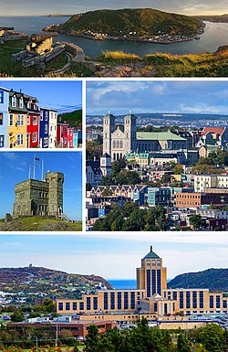
St. John's is the capital and largest city of the Canadian province of Newfoundland and Labrador. It is located on the eastern tip of the Avalon Peninsula...
160 KB (13,416 words) - 06:02, 30 June 2025

Newfoundland and Labrador is the easternmost province of Canada, in the country's Atlantic region. The province comprises the island of Newfoundland and...
200 KB (19,036 words) - 22:03, 19 June 2025

in the Canadian province of Newfoundland and Labrador. It connects the town of Burgeo with the Trans-Canada Highway (Route 1). The highway is a winding...
4 KB (286 words) - 16:35, 18 April 2023

Route 30 is a 12.0-kilometre-long (7.5 mi) north-south provincial highway in Newfoundland and Labrador, extending from St. John's through Logy Bay-Middle...
3 KB (180 words) - 23:28, 14 February 2024

Twillingate (redirect from Twillingate, Newfoundland and Labrador)
island of Newfoundland in the province of Newfoundland and Labrador, Canada. The town is about 100 kilometres (62 mi) north of Lewisporte and Gander. Incorporated...
26 KB (2,560 words) - 04:23, 3 October 2024

Route 20 is a 30.2-kilometre-long (18.8 mi) provincial highway in Newfoundland and Labrador, extending from St. John's to the towns of Torbay, Flatrock...
6 KB (302 words) - 21:23, 31 January 2025
in the northeastern part of the island of Newfoundland in the Canadian province of Newfoundland and Labrador, approximately 40 km (25 mi) south of Gander...
36 KB (2,692 words) - 23:27, 22 June 2025

Route 422, also known as Cormack Road, is a relatively short highway on western Newfoundland in the Canadian province of Newfoundland and Labrador. The...
3 KB (199 words) - 12:46, 29 June 2025

northernmost permanent settlement in the Canadian province of Newfoundland and Labrador, within the Nunatsiavut region, located about 370 km (230 mi)...
34 KB (1,981 words) - 20:40, 19 June 2025
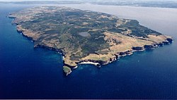
Bell Island is an island that is part of Newfoundland and Labrador, Canada's easternmost province. With an area of 34 square kilometres (13 sq mi), it...
127 KB (15,376 words) - 00:59, 1 July 2025

on the Bonavista Peninsula, Newfoundland in the Canadian province of Newfoundland and Labrador. Unlike many Newfoundland coastal settlements, Bonavista...
21 KB (1,181 words) - 01:38, 4 April 2025

Newfoundland in the Canadian province of Newfoundland and Labrador. It begins at a junction of Route 430 in Wiltondale and terminates at Trout River. It serves...
4 KB (244 words) - 18:21, 5 April 2024

province of Newfoundland and Labrador still has railway transportation, operating on mainland Labrador. The Quebec, North Shore & Labrador Railway (QNSL)...
28 KB (2,379 words) - 03:24, 9 March 2025
community in the province of Newfoundland and Labrador, Canada. It is home to the Churchill Falls Generating Station and is a company town. John McLean...
13 KB (569 words) - 10:48, 27 May 2025

Route 239 is a highway in the Trinity Bight portion of Newfoundland in the Canadian province of Newfoundland and Labrador. It is a short route, running...
3 KB (216 words) - 15:16, 22 October 2022

Cove-St. Philips in Newfoundland and Labrador, Canada. Route 40 also serves as the primary access to St. John's International Airport and the Bell Island...
4 KB (271 words) - 21:09, 30 August 2024

of Newfoundland and Labrador. It connects the town of Cartwright, along with the community of Paradise River, with the Trans-Labrador Highway (Route 510)...
4 KB (260 words) - 20:58, 14 July 2024
Labrador City is a town in western Labrador (part of the Canadian province of Newfoundland and Labrador), near the Quebec border. With a population of...
22 KB (1,077 words) - 23:33, 29 April 2025

highway on the Avalon Peninsula of Newfoundland. It runs between the town of Cupids and the city of St. John's. Route 60 begins as Topsail Road at the west...
8 KB (342 words) - 08:54, 1 July 2025

Route 201 (known as the Osprey Trail) is a provincial road in the Canadian province of Newfoundland and Labrador. It is one of only three loop roads designated...
4 KB (288 words) - 01:44, 16 July 2024

Route 390, also known as Springdale Road, is a highway in the central portion of Newfoundland in the Canadian province of Newfoundland and Labrador. It...
3 KB (194 words) - 01:44, 16 July 2024