
highway located in the western region of Newfoundland in the Canadian province of Newfoundland and Labrador. It starts at its southern terminus at an...
5 KB (265 words) - 18:22, 5 April 2024
This is a list of highways in Newfoundland and Labrador. Newfoundland and Labrador is unusual among jurisdictions in Canada in that it exclusively uses...
39 KB (2,795 words) - 03:06, 2 March 2024

The Trans-Labrador Highway (TLH) is the primary public road in Labrador, the mainland portion of the province of Newfoundland and Labrador, Canada. The...
25 KB (1,536 words) - 11:01, 17 February 2025
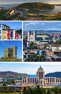
St. John's is the capital and largest city of the Canadian province of Newfoundland and Labrador. It is located on the eastern tip of the Avalon Peninsula...
160 KB (13,416 words) - 21:35, 26 June 2025

of Newfoundland and Labrador. Its eastern terminus is the intersection at the Trans-Canada Highway (Route 1) in the Town of Badger, and the route ends...
4 KB (312 words) - 01:44, 16 July 2024

signage of any kind at the intersection between Route 422 and Route 420. "Newfoundland and Labrador highway 422 ( Cormack Road )". Roads Now. Roads Now...
3 KB (199 words) - 18:21, 5 April 2024

of Newfoundland and Labrador. It connects the town of Hampden, along with some other communities, with Route 420 (White Bay South Highway). Route 421...
2 KB (145 words) - 18:22, 5 April 2024

Route 201 (known as the Osprey Trail) is a provincial road in the Canadian province of Newfoundland and Labrador. It is one of only three loop roads designated...
4 KB (288 words) - 01:44, 16 July 2024
province of Newfoundland and Labrador. It is located in the center region of the island of Newfoundland. The town had a population of 420 in 2021, down...
7 KB (339 words) - 02:29, 28 January 2023

Canadian province of Newfoundland and Labrador. The route begins at the intersection of Route 1 (The Trans Canada Highway) in Deer Lake and ends in St. Anthony...
14 KB (825 words) - 18:21, 5 April 2024
Ontario Highway 420 New Brunswick Route 420 Newfoundland and Labrador Route 420 R420 road Japan National Route 420 Norwegian County Road 420 N-420 A420 road...
2 KB (163 words) - 22:26, 4 April 2024

in the Canadian province of Newfoundland and Labrador. It connects the town of Burgeo with the Trans-Canada Highway (Route 1). The highway is a winding...
4 KB (286 words) - 16:35, 18 April 2023

Newfoundland and Labrador. It leads from Sheppardville, at Route 1 (Trans-Canada Highway), to a dead end in Fleur de Lys, Newfoundland and Labrador....
5 KB (314 words) - 03:31, 24 May 2025

Route 406, also known as Codroy Road, is a highway on the western portion of Newfoundland in the Canadian province of Newfoundland and Labrador. It is...
4 KB (217 words) - 01:44, 16 July 2024

Route 20 is a 30.2-kilometre-long (18.8 mi) provincial highway in Newfoundland and Labrador, extending from St. John's to the towns of Torbay, Flatrock...
6 KB (302 words) - 21:23, 31 January 2025

Route 390, also known as Springdale Road, is a highway in the central portion of Newfoundland in the Canadian province of Newfoundland and Labrador. It...
3 KB (194 words) - 01:44, 16 July 2024
Route 1 is a highway in the Canada province of Newfoundland and Labrador, and is the easternmost stretch of the Trans-Canada Highway. Route 1 is the primary...
32 KB (1,175 words) - 00:58, 24 December 2024

Route 213 is a highway on the Burin Peninsula of the island of Newfoundland in the Canadian province of Newfoundland and Labrador. It is one of a small...
3 KB (189 words) - 15:10, 22 October 2022
Route 71 (also known as Hodgewater Line) is a highway in the Canadian province of Newfoundland and Labrador. It serves as a bypass road to Route 70 and...
3 KB (118 words) - 01:45, 16 July 2024

of Newfoundland and Labrador. It connects the town of Cartwright, along with the community of Paradise River, with the Trans-Labrador Highway (Route 510)...
4 KB (260 words) - 20:58, 14 July 2024

Newfoundland in the Canadian province of Newfoundland and Labrador. It begins at a junction of Route 430 in Wiltondale and terminates at Trout River. It serves...
4 KB (244 words) - 18:21, 5 April 2024

Route 360, also known as Bay d'Espoir Highway, is a provincial highway in Newfoundland and Labrador. It runs from the Bishop's Falls area to Bay d'Espoir...
7 KB (426 words) - 01:44, 16 July 2024

two being where Route 320 transitions to Route 330 (Road to the Shore/Gander Bay Road). List of Newfoundland and Labrador highways "Route 320" (Map). Google...
4 KB (210 words) - 15:29, 15 July 2024
in the northeastern part of the island of Newfoundland in the Canadian province of Newfoundland and Labrador, approximately 40 km (25 mi) south of Gander...
36 KB (2,692 words) - 23:27, 22 June 2025

Peninsula of Newfoundland in the Canadian province of Newfoundland and Labrador. It extends from the city of St. John's west to Paradise. Route 50 begins...
4 KB (256 words) - 23:29, 14 February 2024

Route 470, also known as La Poile Highway, is a highway on the West Coast of the Canadian province of Newfoundland and Labrador. It is the last provincial...
5 KB (368 words) - 01:44, 16 July 2024

Route 380 (also known as the Beothuck Trail) is a highway in Newfoundland and Labrador. There are five communities along the route, beginning with South...
5 KB (294 words) - 01:44, 16 July 2024

Route 30 is a 12.0-kilometre-long (7.5 mi) north-south provincial highway in Newfoundland and Labrador, extending from St. John's through Logy Bay-Middle...
3 KB (180 words) - 23:28, 14 February 2024

Route 239 is a highway in the Trinity Bight portion of Newfoundland in the Canadian province of Newfoundland and Labrador. It is a short route, running...
3 KB (216 words) - 15:16, 22 October 2022

Province of Newfoundland and Labrador. It connects the towns of Harry's Harbour and King's Point with Springdale and the Trans-Canada Highway (Route 1), via...
3 KB (196 words) - 00:45, 4 January 2025