
Route 61, a.k.a. Foxtrap Access Road, is a short access road which connects the Trans-Canada Highway with Foxtrap, part of the town of Conception Bay South...
2 KB (116 words) - 18:39, 18 May 2025
This is a list of highways in Newfoundland and Labrador. Newfoundland and Labrador is unusual among jurisdictions in Canada in that it exclusively uses...
39 KB (2,795 words) - 03:06, 2 March 2024

The Trans-Labrador Highway (TLH) is the primary public road in Labrador, the mainland portion of the province of Newfoundland and Labrador, Canada. The...
25 KB (1,536 words) - 11:01, 17 February 2025

Trinity is a small town located on Trinity Bay in Newfoundland and Labrador. The town contains a number of buildings recognized as Registered Heritage...
14 KB (1,068 words) - 07:02, 1 March 2025

Labrador (/ˈlæbrədɔːr/) is a geographic and cultural region within the Canadian province of Newfoundland and Labrador. It is the primarily continental...
64 KB (5,850 words) - 16:13, 23 June 2025
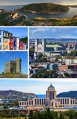
St. John's is the capital and largest city of the Canadian province of Newfoundland and Labrador. It is located on the eastern tip of the Avalon Peninsula...
160 KB (13,416 words) - 21:35, 26 June 2025
Party of Newfoundland and Labrador is a provincial political party in Newfoundland and Labrador, Canada. The party was founded in 1949 and most recently...
100 KB (9,730 words) - 22:48, 23 June 2025
Labrador City is a town in western Labrador (part of the Canadian province of Newfoundland and Labrador), near the Quebec border. With a population of...
22 KB (1,077 words) - 23:33, 29 April 2025

in the Canadian province of Newfoundland and Labrador. It connects the town of Burgeo with the Trans-Canada Highway (Route 1). The highway is a winding...
4 KB (286 words) - 16:35, 18 April 2023

L'Anse Amour (redirect from L'Anse Amour, Newfoundland and Labrador)
hamlet located on the north shore of the Strait of Belle Isle, Newfoundland and Labrador, Canada. As of 2006, it had a population of 8. The population...
11 KB (816 words) - 18:42, 2 May 2025
Route 1 is a highway in the Canada province of Newfoundland and Labrador, and is the easternmost stretch of the Trans-Canada Highway. Route 1 is the primary...
32 KB (1,175 words) - 00:58, 24 December 2024

highway on the Avalon Peninsula of Newfoundland. It runs between the town of Cupids and the city of St. John's. Route 60 begins as Topsail Road at the west...
8 KB (342 words) - 06:57, 16 January 2023
in the northeastern part of the island of Newfoundland in the Canadian province of Newfoundland and Labrador, approximately 40 km (25 mi) south of Gander...
36 KB (2,692 words) - 23:27, 22 June 2025
Canadian province of Newfoundland and Labrador. St. Anthony serves as a main service centre for northern Newfoundland and southern Labrador. St. Anthony had...
23 KB (1,651 words) - 15:36, 24 June 2025

northernmost permanent settlement in the Canadian province of Newfoundland and Labrador, within the Nunatsiavut region, located about 370 km (230 mi)...
34 KB (1,981 words) - 20:40, 19 June 2025

province of Newfoundland and Labrador. The road provides a direct link from the Trans-Canada Highway (TCH) to downtown St. John's, Newfoundland, which was...
10 KB (653 words) - 22:11, 30 August 2024

part of the island of Newfoundland in the province of Newfoundland and Labrador, Canada. The town derives its name from Deer Lake and is situated at the...
14 KB (885 words) - 08:32, 1 May 2025
The Whaler's Restaurant (fish & chips and related cuisine) List of cities and towns in Newfoundland and Labrador Statistics Canada (2006). "Red Bay Community...
14 KB (1,173 words) - 02:27, 18 January 2025
community in the province of Newfoundland and Labrador, Canada. It is home to the Churchill Falls Generating Station and is a company town. John McLean...
13 KB (569 words) - 10:48, 27 May 2025

province of Newfoundland and Labrador still has railway transportation, operating on mainland Labrador. The Quebec, North Shore & Labrador Railway (QNSL)...
28 KB (2,379 words) - 03:24, 9 March 2025

Twillingate (redirect from Twillingate, Newfoundland and Labrador)
island of Newfoundland in the province of Newfoundland and Labrador, Canada. The town is about 100 kilometres (62 mi) north of Lewisporte and Gander. Incorporated...
26 KB (2,560 words) - 04:23, 3 October 2024

intersection between Route 320 (Road to the Shore) and a local road to Wesleyville. List of Newfoundland and Labrador highways "Route 330" (Map). Google...
7 KB (355 words) - 21:46, 21 May 2024

Portugal Cove–St. Philip's (redirect from Portugal Cove, Newfoundland and Labrador)
community located on the eastern Avalon Peninsula of Newfoundland in the province of Newfoundland and Labrador, Canada. The town is a bedroom community of the...
9 KB (574 words) - 12:02, 7 May 2024

Conception Bay South (redirect from Topsail, Newfoundland and Labrador)
Conception Bay South is a town in the Province of Newfoundland and Labrador, Canada. The town is commonly called CBS. The town is located on the Avalon...
16 KB (1,513 words) - 11:39, 17 May 2025

the Avalon Peninsula of Newfoundland. The highway also carries the designation of Baccalieu Trail for its entire length. Route 70 begins in Roaches Line...
9 KB (348 words) - 01:43, 16 July 2024

Island, the largest of the offshore islands in the province of Newfoundland and Labrador, Canada. The Town of Fogo Island was incorporated on March 1,...
27 KB (996 words) - 09:18, 27 May 2025

Happy Valley-Goose Bay (redirect from Goose Bay, Newfoundland and Labrador)
a town in the province of Newfoundland and Labrador, Canada. Located in central Labrador on the coast of Lake Melville and the Churchill River, Happy...
24 KB (1,454 words) - 18:45, 14 June 2025
(12 mi) from Clarenville, Newfoundland and Labrador along Route 230, on the Cabot Highway, to Bonavista. Route 233 and Route 234 also pass through the...
7 KB (305 words) - 20:52, 3 March 2025

Newfoundland and Labrador is the easternmost province of Canada, in the country's Atlantic region. The province comprises the island of Newfoundland and...
200 KB (19,036 words) - 22:03, 19 June 2025
entrance to Sandwich Bay, along the southern coast of Labrador in the province of Newfoundland and Labrador, Canada. It was incorporated in 1956. Sandwich Bay...
16 KB (612 words) - 00:33, 3 June 2025