
Nungarin is a town located in the north east of the Wheatbelt region of Western Australia, approximately 278 kilometres (173 mi) east of Perth and 39...
11 KB (819 words) - 11:05, 8 October 2023
an abandoned townsite in the Wheatbelt region of Western Australia, located in the Shire of Nungarin on the Koorda–Bullfinch Road. It is situated within...
6 KB (573 words) - 04:21, 1 May 2024

The Shire of Nungarin is a local government area in the Wheatbelt region of Western Australia, and with a population of 255 as of the 2021 census, is one...
8 KB (593 words) - 06:25, 11 October 2023

The Wheatbelt is one of nine regions of Western Australia defined as administrative areas for the state's regional development, and a vernacular term...
18 KB (1,526 words) - 04:20, 1 May 2024
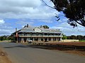
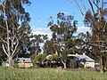
The Nungarin Army Vehicle Workshop is a heritage listed building in Nungarin, Western Australia currently operating as the Nungarin Heritage Machinery...
2 KB (159 words) - 05:16, 7 August 2022
by the Heritage Council of Western Australia. As of 2023[update], 64 places are heritage-listed in the Shire of Nungarin, of which eight are on the State...
3 KB (113 words) - 08:15, 25 February 2023

of Western Australia form the basis of a road network, which is primarily used by the mining, agriculture, and tourism industries. Main Roads Western Australia...
44 KB (2,661 words) - 02:22, 11 May 2024

Kulin is a town in the eastern Wheatbelt region of Western Australia, approximately 280 km from Perth. It is the main town in the Shire of Kulin. The...
8 KB (956 words) - 19:42, 25 April 2024
and Central Districts Index. 28 January 1926. "Nungarin Road Board". Dampier Herald. Western Australia. 29 June 1933. p. 2. Retrieved 23 January 2020...
4 KB (405 words) - 08:40, 6 May 2024
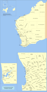
There are 137 local government areas (LGAs) in Western Australia, which comprise 27 cities, 102 shires, and 8 towns that manage their own affairs to the...
60 KB (1,458 words) - 21:17, 6 March 2024
Mooliabeenee (also found misspelt as Mooliabeenie) is a locality in Western Australia, east of Gingin, within the Shire of Chittering. The nearby Mooliabeenie...
4 KB (245 words) - 09:23, 13 February 2024
Murchison) Northampton Shire Libraries (Shire of Northampton) Nungarin Public Library (Shire of Nungarin) Perenjori Shire Council Libraries (Shire of Perenjori)...
13 KB (1,193 words) - 07:15, 23 May 2024
Mangowine Homestead (category Nungarin, Western Australia)
Mangowine Homestead is an historic homestead in Nungarin, Western Australia, built by Charles Frederick and Jane Swain Adams. It comprises a cottage built...
3 KB (137 words) - 12:51, 22 May 2022

Gingin is a town in Western Australia, located on the Brand Highway 67 kilometres (42 mi) north of the Perth city centre. It is the council seat for the...
6 KB (645 words) - 12:22, 4 June 2024
"Muchea (urban centre and locality)". Australian Census 2021. "History of country town names – M". Western Australian Land Information Authority. Archived...
3 KB (241 words) - 15:23, 23 August 2023
Dumbleyung is a town and shire in the Wheatbelt region of Western Australia, 267 kilometres (166 mi) south-east of Perth between Wagin and Lake Grace...
5 KB (544 words) - 08:15, 7 February 2023

Westonia is a small town located in the eastern Wheatbelt region of Western Australia, 10 kilometres (6 mi) north of the Great Eastern Highway. It is the...
3 KB (327 words) - 14:11, 12 February 2023

York is the oldest inland town in Western Australia, situated on the Avon River, 97 kilometres (60 mi) east of Perth in the Wheatbelt, on Ballardong Nyoongar...
50 KB (5,096 words) - 01:47, 17 June 2024

and 1910, is a town on the Avon River in the Wheatbelt region of Western Australia, 85 kilometres (53 mi) north-east of Perth. The first European settlement...
26 KB (2,539 words) - 16:33, 6 June 2024

Wheatbelt region of Western Australia, about 80 kilometres (50 mi) east-north-east of Perth. John Forrest, later Premier of Western Australia, recorded the...
20 KB (1,908 words) - 01:41, 19 January 2024

Quairading is a Western Australian town located in the Wheatbelt region. It is the seat of government for the Shire of Quairading. The town was named for...
13 KB (1,334 words) - 11:51, 28 February 2024

Hyden is located 292 kilometres (181 mi) east-southeast of Perth, Western Australia in the Shire of Kondinin. Hyden is home to Wave Rock, Mulka's Cave...
6 KB (647 words) - 15:55, 8 February 2023
the Wheatbelt region of Western Australia. The town's name is taken from the nearby Wannamal Lake, a name of Indigenous Australian origin that was first...
2 KB (198 words) - 04:40, 2 October 2023
Walebing is a small town in the wheatbelt region of Western Australia, in the Shire of Moora, it takes its name from the original homestead established...
3 KB (85 words) - 02:11, 10 February 2023
kilometres (5.6 mi) northeast of Dowerin in the Wheatbelt region of Western Australia. It was an important junction for the railway line going north to...
2 KB (173 words) - 14:04, 9 August 2022

of the town led to confusion between other towns such as Narrogin and Nungarin. The name was changed to Bruce Rock after the large granite feature located...
4 KB (368 words) - 13:42, 30 December 2023
Mandiga is a town in Western Australia, in the Shire of Mount Marshall. It is located between the towns of Koorda and Mukinbudin in the Wheatbelt region...
2 KB (141 words) - 06:47, 9 May 2020
Gwambygine is a small town in the Wheatbelt region of Western Australia. It is situated between the towns of York and Beverley, on the banks of the Avon...
5 KB (356 words) - 13:38, 14 February 2023
located 54 km (34 mi) north-northeast of the town of Southern Cross, Western Australia. Iron ore has been mined here since 1948 by a series of companies...
6 KB (615 words) - 03:23, 30 March 2024

central Wheatbelt region of Western Australia, 229 kilometres (142 mi) east-southeast of the state capital, Perth, Western Australia, along State Route 40....
11 KB (977 words) - 19:31, 25 April 2024