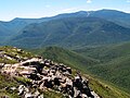
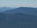
Owl's Head is a 4,025-foot (1,227 m) mountain in Franconia, New Hampshire. It lies between the Franconia Branch of the Pemigewasset River (to its east)...
3 KB (319 words) - 19:31, 10 July 2022

Franconia is a town in Grafton County, New Hampshire, United States. The population was 1,083 at the 2020 census. Set in the White Mountains, Franconia...
15 KB (1,350 words) - 14:26, 3 May 2024
Airport Owl's Head (Carroll, New Hampshire), a mountain in Coös County Owl's Head (Franconia, New Hampshire), a mountain in Grafton County Owls Head (Hebron...
894 bytes (163 words) - 06:13, 21 May 2023

for inclusion in the WMNF. Owl's Head (Franconia, New Hampshire), on the White Mountains list of 4,000-footers New Hampshire portal 44°20′19″N 71°29′33″W...
1 KB (165 words) - 15:10, 3 July 2023
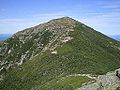
359 m) mountain in the White Mountains of New Hampshire. Overlooking Franconia Notch, it is part of Franconia Ridge, the second highest mountain group...
2 KB (128 words) - 17:28, 21 March 2023

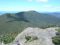
Franconia Range of the White Mountains of New Hampshire. Lincoln is located between Little Haystack and Mount Lafayette. All three overlook Franconia...
3 KB (142 words) - 02:52, 3 December 2023
programs adopted from Franconia College, which closed in 1978. In 1981, New Hampshire College received authorization from the New Hampshire legislature to offer...
57 KB (4,674 words) - 06:47, 31 March 2024
Mount Lafayette (redirect from Mount Lafayette (New Hampshire))
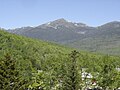
the Franconia Range in the White Mountains of New Hampshire, United States. It lies in the town of Franconia in Grafton County, and appears on the New England...
9 KB (701 words) - 01:09, 22 May 2024

The below list of Mountains in New Hampshire is an incomplete list of mountains in the U.S. state of New Hampshire, with elevation. This list includes...
52 KB (888 words) - 21:15, 13 May 2024
Pemigewasset Wilderness (category Wilderness areas of New Hampshire)
encircling Owl's Head are two tributaries of the East Branch, Lincoln Brook and Franconia Branch; Lincoln Brook drains the east face of Franconia Ridge, while...
13 KB (1,298 words) - 07:32, 8 December 2023

Mount Tripyramid is a mountain located in Grafton County, New Hampshire. Part of the Sandwich Range of the White Mountains, it has three distinct peaks...
5 KB (287 words) - 02:56, 28 June 2023

Mount Pemigewasset (redirect from Indian Head (New Hampshire))
Mount Pemigewasset, or Indian Head, is a mountain in Franconia Notch in the White Mountains in Grafton County, New Hampshire, United States. It lies near...
7 KB (513 words) - 23:29, 21 February 2024
Mount Garfield is a mountain located in Grafton County, New Hampshire. The mountain is part of the White Mountains. Mt. Garfield is flanked to the east...
3 KB (196 words) - 02:58, 28 June 2023

mountain located in Coos County, New Hampshire. The mountain is named after Charles Thomas Jackson, New Hampshire's state geologist in the 19th century...
3 KB (180 words) - 20:02, 11 April 2023

Mount Monroe (redirect from Mount Monroe (New Hampshire))
in New Hampshire, United States. It is named for American President James Monroe and is the fourth highest mountain on the 4000 footers list for New Hampshire...
6 KB (622 words) - 15:06, 3 July 2023
Mount Tom is a mountain located in Grafton County, New Hampshire, about 1.5 miles (2.4 km) southwest of the height of land of Crawford Notch. The mountain...
3 KB (297 words) - 19:25, 10 July 2022

East Peak Mount Osceola (redirect from East Osceola Mountain (New Hampshire))
The East Peak of Mount Osceola is one of the official New Hampshire 4000-footers, standing at an elevation of 4,156 feet (1,267 m). East Osceola's prominence...
3 KB (171 words) - 08:40, 20 March 2024

Mount Moosilauke (redirect from Mount Moosilauke (New Hampshire))
the southwestern end of the White Mountains in the town of Benton, New Hampshire, United States. It is the tenth highest and most southwesterly of the...
10 KB (953 words) - 22:00, 20 October 2023
Mount Madison (redirect from Mount Madison (New Hampshire))
Madison is a 5,367-foot (1,636 m) mountain in the Presidential Range of New Hampshire in the United States. It is named after the fourth U.S. President, James...
6 KB (361 words) - 03:41, 17 May 2024

Mount Hancock is a mountain in Grafton County, New Hampshire, named after John Hancock (1737–1793), one of the Founding Fathers of the United States....
4 KB (262 words) - 06:35, 8 August 2022

Mount Field is a mountain located in Grafton County, New Hampshire. The mountain is named after Darby Field (1610–1649), who in 1642 made the first known...
3 KB (218 words) - 02:56, 28 June 2023

Carter Dome (redirect from Carter Dome (New Hampshire))
Carter Dome, or simply The Dome, is a mountain located in Coos County, New Hampshire. The mountain is part of the Carter-Moriah Range of the White Mountains...
5 KB (347 words) - 05:34, 17 May 2024

Mount Hale is a mountain located in Grafton County, New Hampshire. The mountain is named after Reverend Edward Everett Hale (1822–1909), and is part of...
2 KB (149 words) - 19:25, 10 July 2022

Mount Carrigain (redirect from Mount Carrigain (New Hampshire))
Mount Carrigain is a mountain located in Grafton County, New Hampshire. The mountain is named after Phillip Carrigain, NH Secretary of State (1805–10)...
7 KB (453 words) - 00:27, 23 October 2023

Mount Moriah is a mountain located in Coos County, New Hampshire. The mountain is part of the Carter-Moriah Range of the White Mountains, which runs along...
4 KB (215 words) - 19:57, 26 October 2023

Illuminati (section New system)
advanced Knigge 50 florins to travel to Bavaria, which he did via Swabia and Franconia, meeting and enjoying the hospitality of other Illuminati on his journey...
55 KB (7,155 words) - 21:07, 9 May 2024
Appalachian Trail (category Hiking trails in New Hampshire)
View from Mount Greylock in Massachusetts Franconia Ridge, a section of the Appalachian Trail in New Hampshire Northern terminus of the trail atop Mount...
125 KB (12,269 words) - 06:17, 8 May 2024
Middle Carter Mountain (redirect from Middle Carter Mountain (New Hampshire))
Middle Carter Mountain is a mountain located in Coos County, New Hampshire. The mountain is part of the Carter-Moriah Range of the White Mountains, which...
4 KB (211 words) - 19:11, 26 October 2023

Mount Nancy (category Mountains of New Hampshire)
formerly Mount Amorisgelu, is a mountain located in Grafton County, New Hampshire, on the eastern boundary of the Pemigewasset Wilderness of the White...
4 KB (409 words) - 02:56, 28 June 2023

Mount Tecumseh (category Mountains of New Hampshire)
Mount Tecumseh is a mountain located in Grafton County, New Hampshire. The mountain is named after the Shawnee leader Tecumseh (c. 1768–1813), and is...
3 KB (238 words) - 19:10, 7 April 2024