Pat Sin Leng (Chinese: 八仙嶺) is a mountain range in the northeast New Territories of Hong Kong, located within the Pat Sin Leng Country Park. The name Pat...
5 KB (595 words) - 06:21, 31 March 2024

The 1996 Pat Sin Leng wildfire took place in Pat Sin Leng, Tai Po, New Territories, Hong Kong on 10 February, 1996 (Saturday). It was the worst wildfire...
6 KB (802 words) - 17:21, 2 January 2024
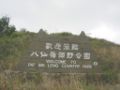
Pat Sin Leng Country Park (Chinese: 八仙嶺郊野公園; Jyutping: Baat3 Sin1 Leng5 Gaau1 Je5 Gung1 Jyun2) is a country park in Hong Kong located in the northeastern...
3 KB (359 words) - 03:13, 8 April 2021

Park and Tai Mo Shan Country Park. Finally it climbs into the majestic Pat Sin Leng Country Park. Each of the Country Parks the Wilson Trail traverses has...
19 KB (2,413 words) - 12:06, 22 April 2024
by the Hong Kong Government known as Standard Romanisation, 'shan' and 'leng' are the transliterations of the Cantonese words for 'mount' (山) and 'ridge'...
21 KB (248 words) - 03:23, 23 February 2024

of Lumnitzera racemosa can be found. A part of Ting Kok is within the Pat Sin Leng Country Park, and the Ting Kok wetlands have been declared a Site of...
9 KB (751 words) - 06:18, 9 March 2024

a revered figure in Buddhism. It is located in a scenic area, with Pat Sin Leng mountain range behind it and Plover Cove Reservoir in front. The monastery...
6 KB (684 words) - 16:38, 21 February 2024
coastlines in all parts of Hong Kong. The parks include Tai Mo Shan, Pat Sin Leng mountain range, Ma On Shan, Lion Rock, Sai Kung Peninsula, forest plantations...
26 KB (2,856 words) - 21:24, 29 April 2024

hill in Tai Po District of northeastern Hong Kong. It is located within Pat Sin Leng Country Park. The source of the Ma Wat River is located on Cloudy Hill...
1 KB (93 words) - 17:47, 26 August 2023

Wong Leng (Chinese: 黃嶺; literally: "Yellow Ridge") is on section 9 of the Wilson Trail in Pat Sin Leng Country Park, Hong Kong. It is 639 metres tall...
2 KB (86 words) - 17:47, 26 August 2023
Yuen Kei Ling Ha Lo Wai Lam Tsuen Nai Chung Pak Shek Kok Science Park Pat Sin Leng Ping Chau Plover Cove Science Park Pak Shek Kok Shap Sze Heung Tai Po...
9 KB (862 words) - 10:36, 12 March 2024
village in the Tai Po District of Hong Kong Wong Leng, section 9 of the Wilson trail in Pat Sin Leng Country Park, Hong Kong Wong Nai Chung Gap, a geographic...
5 KB (732 words) - 11:48, 16 April 2024

Territories East Clear Water Bay Kam Shan Kiu Tsui Lion Rock Ma On Shan Pat Sin Leng Plover Cove Plover Cove (Ext.) Robin's Nest Sai Kung East Sai Kung West...
5 KB (443 words) - 15:15, 24 March 2024

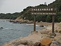
of the Hong Kong Geopark. Islands portal Crooked Harbour Double Haven Pat Sin Leng Country Park "List of Recognized Villages under the New Territories Small...
8 KB (717 words) - 07:43, 29 May 2024
destroyed on the Chinese side alone and spread to the Soviet side. 1996 – Pat Sin Leng wildfire, Tai Po; 5 hikers killed (3 pupils and 2 teachers) on 10 February...
60 KB (3,252 words) - 17:13, 25 May 2024

(囚鳥), and the Cantonese album, Water (清水), which commemorated the 1996 Pat Sin Leng wildfire. She also recorded To Embrace Your Days (抱著你的日子), and performed...
8 KB (1,064 words) - 14:23, 8 November 2023

Territories of Hong Kong. The river originates in Ping Fung Shan near Pat Sin Leng. It flows through the Hok Tau Reservoir and Ping Che before finally emptying...
1 KB (117 words) - 17:39, 2 April 2023

or by the Hok Tau Reservoir Family Walk. It is within the borders of Pat Sin Leng Country Park and the family trail has many barbecue sites adjacent to...
2 KB (103 words) - 07:59, 31 August 2021
and early 1990s Mountains of the Eight Immortals, the eight peaks of Pat Sin Leng, in the northeast New Territories of Hong Kong Eight Immortals Mountain...
940 bytes (154 words) - 14:01, 21 April 2023

Tai Po District of the New Territories, Hong Kong, under the hills of Pat Sin Leng. The area is mainly rural and has a few villages. The campus of The Education...
3 KB (289 words) - 06:16, 9 March 2024
engineering programme, is a reservoir located within the boundary of Pat Sin Leng Country Park in the eastern part of North District, New Territories,...
7 KB (746 words) - 05:47, 24 September 2023
Territories East Clear Water Bay Kam Shan Kiu Tsui Lion Rock Ma On Shan Pat Sin Leng Plover Cove Plover Cove (Ext.) Robin's Nest Sai Kung East Sai Kung West...
4 KB (381 words) - 09:35, 9 March 2024

Botanic Gardens, Hong Kong. In Hong Kong, where it occurs on Ma On Shan, Pat Sin Leng, Wu Kau Tang, and Lantau Island, it is a protected species under Forestry...
2 KB (244 words) - 18:19, 15 December 2023

Territories East Clear Water Bay Kam Shan Kiu Tsui Lion Rock Ma On Shan Pat Sin Leng Plover Cove Plover Cove (Ext.) Robin's Nest Sai Kung East Sai Kung West...
7 KB (649 words) - 16:13, 26 December 2023
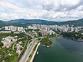
The Beverly Hills, with the Pat Sin Leng range in the background....
28 KB (2,795 words) - 05:01, 13 June 2024

Territories East Clear Water Bay Kam Shan Kiu Tsui Lion Rock Ma On Shan Pat Sin Leng Plover Cove Plover Cove (Ext.) Robin's Nest Sai Kung East Sai Kung West...
12 KB (881 words) - 10:33, 16 June 2023

next to the shopping centre of Ma On Shan Plaza. The natural scenery of Pat Sin Leng and Tolo Harbour can be viewed from the park. The park occupies 5.5 hectares...
3 KB (183 words) - 00:23, 16 May 2021

near Tolo Channel and Tolo Harbour. It is encircled by the hills Pat Sin Leng and Wan Leng (橫嶺), the Yim Tin Tsai, Ma Shi Chau and Tung Tau Chau (東頭洲) island...
3 KB (341 words) - 02:51, 5 May 2024

Tin Hau, built in 1765, and a temple dedicated to Tam Kung: the Tam Tai Sin Temple (譚大仙廟), built before 1877. Both temples are located in the village...
21 KB (2,099 words) - 04:05, 16 April 2024

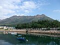
Lung Mei viewed from Ting Kok Road. The Pat Sin Leng mountain range is visible in the background....
4 KB (332 words) - 10:33, 28 April 2024