The Permanent Service for Mean Sea Level is a repository for tide gauge data used in the measurement of long-term sea level change. The PSMSL is based...
3 KB (310 words) - 08:46, 28 January 2024

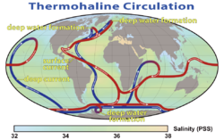
Mean sea level (MSL, often shortened to sea level) is an average surface level of one or more among Earth's coastal bodies of water from which heights...
21 KB (4,046 words) - 17:07, 12 March 2025
David Thomas Pugh (redirect from Tides, surges, and mean sea-level)
Sea Level Observing System, was President of the Intergovernmental Oceanographic Commission of UNESCO, Director of the Permanent Service for Mean Sea...
9 KB (698 words) - 16:57, 13 May 2025
concept for GLOSS was proposed to the IOC by oceanographers David Pugh and Klaus Wyrtki in order to develop the Permanent Service for Mean Sea Level (PSMSL)...
3 KB (392 words) - 00:25, 18 January 2024

sea dynamics, it is home to the Coastal Observatory in Liverpool Bay; the National Tidal and Sea Level Facility, the Permanent Service for Mean Sea Level...
12 KB (1,477 words) - 10:45, 25 March 2025

Tide gauge (redirect from Water level sensor)
com. Retrieved 2021-08-14. "Obtaining Tide Gauge Data". Permanent Service for Mean Sea Level. PSMSL. Retrieved 2016-03-07. "Other Long Records not in...
9 KB (873 words) - 01:24, 16 December 2024

Chart datum (redirect from Mean high water springs)
lowest astronomical tide (LAT) and mean lower low water (MLLW). In non-tidal areas, e.g. the Baltic Sea, mean sea level (MSL) is used. A chart datum is a...
10 KB (1,220 words) - 20:30, 20 April 2025

Climate change in Tuvalu (redirect from Sea level rise in Tuvalu)
170ºE–130ºW) (moderate confidence). Sea level observation to collect data for the purpose of the Permanent Service for Mean Sea Level (PSMSL) has been made at two...
75 KB (8,379 words) - 22:18, 6 April 2025
International Association of Geodesy (redirect from International GNSS Service)
International VLBI Service for Geodesy and Astrometry (IVS) International Service for the Geoid (ISG) Permanent Service for Mean Sea Level (PSMSL) The Global...
46 KB (4,852 words) - 23:05, 22 May 2025
List of lakes by depth (category Articles with permanently dead external links)
deepest point above the sea level. These are: Issyk-Kul, Crater Lake, Quesnel, Sarez, Toba, Tahoe, Kivu, Nahuel Huapi, Van and Poso. Mean depth can be a more...
49 KB (974 words) - 18:09, 20 May 2025
specialises in tidal and sea level science. It hosts the National Tidal and Sea Level Facility, the Permanent Service for Mean Sea Level and the British Oceanographic...
8 KB (749 words) - 12:37, 8 May 2025
Journal of Geophysical Research, 115, C04021, doi:10.1029/2009JC005767. NASA JPL Ocean Surface Topography from Space Permanent Service for Mean Sea Level...
5 KB (653 words) - 19:31, 29 June 2021

Survey. URL accessed 2014-01-30. "Obtaining Tide Gauge Data". Permanent Service for Mean Sea Level. PSMSL. Retrieved 7 March 2016. "What is a 100 year flood...
23 KB (2,994 words) - 19:02, 5 April 2025
Federation of Astronomical and Geophysical data-analysis Services, most of the legacy data centers and services continued under the WDS. CODATA International Polar...
16 KB (507 words) - 15:53, 3 March 2025

National Oceanography Centre Southampton (category Articles with permanently dead external links)
installed. Permanent Service for Mean Sea Level – Repository for tide gauge data used in the measurement of long-term sea level change Global Sea Level Observing...
15 KB (1,557 words) - 09:48, 9 March 2025
Outline of oceanography (section Sea level)
variables for the North Sea area Past sea level – Sea level variations over geological time scales Permanent Service for Mean Sea Level – A repository for tide...
226 KB (32,627 words) - 21:34, 2 April 2025

Archived from the original on 14 April 2005. "NEWLYN". Permanent Service for Mean Sea Level. Archived from the original on 3 October 2023. Retrieved...
10 KB (866 words) - 06:39, 2 April 2025
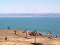
about 5% higher than sea level standard atmospheric pressure of 1013.25 hPa, which is the global ocean mean or ATM.) The Dead Sea affects temperatures...
84 KB (8,786 words) - 15:09, 11 April 2025

Philip Woodworth – Oceanographer; former Director of the Permanent Service for Mean Sea Level David Arkless – President of End Human Trafficking Now (2011–)...
56 KB (4,352 words) - 00:45, 29 April 2025

internationally, and are sent to and are available from the Permanent Service for Mean Sea Level. Adaptations were made in 1996 to incorporate more modern...
7 KB (795 words) - 02:34, 12 January 2025
Woodworth was the Director of the Permanent Service for Mean Sea Level - the global data bank for recording sea-level change. His role involved working...
7 KB (532 words) - 22:20, 11 November 2023
sq mi)[citation needed], with an alititude of 259 m (850 ft) above mean-sea level. Aniocha North Local Government Area experiences the Tropical savanna...
4 KB (193 words) - 13:00, 21 May 2025

altitude is commonly used to mean the height above sea level of a location, in geography the term elevation is often preferred for this usage. In aviation...
26 KB (3,069 words) - 03:28, 26 April 2025
The Fens (redirect from Bedford Level)
(33 ft) above sea level. As a result of drainage and the subsequent shrinkage of the peat fens, many parts of the Fens now lie below mean sea level. Although...
53 KB (6,330 words) - 02:58, 14 April 2025
List of Durham University people (category Articles with permanently dead external links)
Woodworth (Hatfield) - Oceanographer; former Director of the Permanent Service for Mean Sea Level Michael Aris (St Cuthbert's) – Author on Bhutanese, Tibetan...
299 KB (16,930 words) - 02:39, 20 May 2025

an area of 95 acres (38 ha) at an elevation of 64 feet (20 m) above mean sea level. The asphalt paved runway designated 8/26 measured 3,600 by 75 feet...
3 KB (248 words) - 03:14, 6 October 2022
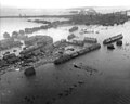
North Sea. The combination of wind, high tide, and low pressure caused the sea to flood land up to 5.6 metres (18 ft 4 in) above mean sea level. Realising...
35 KB (3,862 words) - 16:45, 12 May 2025

Earth (redirect from Mean density of the Earth)
result is a smooth but irregular geoid surface, providing a mean sea level as a reference level for topographic measurements. Earth's surface is the boundary...
219 KB (19,417 words) - 15:59, 22 May 2025

in hundreds of feet or metres. The altimeter setting used is the ISA sea level pressure of 1013 hPa or 29.92 inHg. The actual surface pressure will vary...
26 KB (2,391 words) - 19:19, 27 April 2025

Aniak Airport (category Articles with permanently dead external links)
area of 1,722 acres (697 ha) at an elevation of 89 feet (27 m) above mean sea level. It has one asphalt paved runway designated 11/29 (formerly 10/28) which...
8 KB (436 words) - 23:39, 22 February 2024