Portolan charts are nautical charts, first made in the 13th century in the Mediterranean basin and later expanded to include other regions. The word portolan...
19 KB (2,309 words) - 12:34, 28 May 2025

Aeronautical chart Automatic label placement Admiralty chart Bathymetric chart European Atlas of the Seas Nautical star Navigation room Portolan chart Dutch...
18 KB (2,301 words) - 00:26, 14 June 2025

directions forming a web-like mesh. They were featured on portolan charts and other early nautical charts used in the medieval age and age of exploration in...
11 KB (1,328 words) - 15:08, 16 June 2025

rectangular island in the 1424 portolan chart of Zuane Pizzigano. Thereafter, it routinely appeared in most nautical charts of the 15th century. After 1492...
40 KB (5,239 words) - 15:22, 7 July 2025

of Ireland..." Nautical charts identified an island called "Bracile" west of Ireland in the Atlantic Ocean in a portolan chart by Angelino Dulcert circa...
17 KB (1,539 words) - 02:37, 25 July 2025

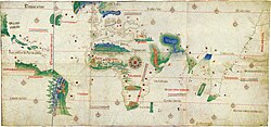
copy of an otherwise lost map by Christopher Columbus. The map is a portolan chart with compass roses and a windrose network for navigation, rather than...
59 KB (6,928 words) - 22:06, 12 July 2025

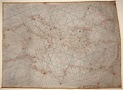
school. The Carta Pisana portolan chart, made at the end of the 13th century (1275–1300), is the oldest surviving nautical chart (that is, not simply a...
143 KB (17,654 words) - 23:22, 23 June 2025

Aragon, to make a set of nautical charts which would go beyond the normal geographic range of contemporary portolan charts to cover the East and the West...
8 KB (839 words) - 20:05, 9 June 2025
portolan charts of the Mediterranean, which were constructed based on magnetic courses and estimated distances between places, in the latitude chart,...
18 KB (2,381 words) - 10:38, 5 June 2025
flag as shown on some portolan charts The Byzantine imperial ensign of the 14th century according to Pietro Vesconte's portolan chart. The flag of Salonica...
42 KB (5,135 words) - 22:13, 11 June 2025

surviving nautical chart (that is, not simply a map but a document showing accurate navigational directions). It is a portolan chart, showing a detailed...
5 KB (658 words) - 23:34, 19 May 2025

accurately-drawn portolan charts, starting with the 1367 chart of Domenico and Francesco Pizzigano and carried on in the 1375 Catalan Atlas, the 1413 chart of the...
50 KB (6,240 words) - 12:19, 24 July 2025

chart Flag over Varna on Guillem Soler's Portolan chart (c.1385) Approximate replica of Soler's portolan chart Flag of Bulgaria on Battista Beccario's...
17 KB (1,497 words) - 20:18, 8 July 2025

Portolan of Angelo Freducci is a portolan chart by Angelo Freducci from 1554. The portolan belonged to the library of the Zamoyski family. After the Warsaw...
4 KB (257 words) - 20:48, 8 May 2025

Compass rose (section Depiction on nautical charts)
eight half-winds and red for the sixteen quarter-winds. The average portolan chart had sixteen such roses (or confluence of lines), spaced out equally...
27 KB (2,818 words) - 04:58, 27 May 2025
of the oldest signed Portolan chart (1311) Angelino Dulcert (14th century), author of the earliest known Majorcan portolan charts of the Mediterranean...
30 KB (3,155 words) - 15:01, 13 March 2025
Mercator projection (redirect from Mercator chart)
analysis that these charts used an equirectangular projection instead. In the 13th century, the earliest extant portolan charts of the Mediterranean...
49 KB (6,857 words) - 01:05, 21 July 2025
notable 14th-century portolan charts, the "Dalorto" chart of 1325 and the "Dulcert" chart of 1339. The latter is the first portolan known to have been produced...
16 KB (1,913 words) - 10:38, 30 June 2025

map is a portolan chart with compass roses from which lines of bearing radiate. Designed for navigation via dead reckoning, portolan charts use a windrose...
70 KB (7,697 words) - 07:48, 15 July 2025

developed breakthroughs in cartographic techniques, namely the "normal portolan chart", which was fine-tuned for navigational use and the plotting by compass...
102 KB (6,993 words) - 18:31, 27 June 2025

portolan chart of Angelino de Dalorto, featuring a red background with a white animal in the center and black stripes. On a Jorge Aguiar's portolan chart...
36 KB (3,950 words) - 04:32, 24 July 2025
traditional mappae mundi but contain elements from other sources, including Portolan charts and maps associated with Ptolemy's Geography are sometimes considered...
15 KB (1,582 words) - 09:10, 21 July 2025

Portolan of Antonio Millo is a portolan chart by Antonio Millo from 1583. The portolan belonged to the library of the Zamoyski family. During the Warsaw...
3 KB (244 words) - 20:48, 8 May 2025

Zuane Pizzigano (redirect from Pizzigano chart)
15th-century Venetian cartographer. He is the author of a famous 1424 portolan chart, the first known to depict the phantom islands of the purported Antillia...
12 KB (1,417 words) - 12:06, 18 November 2024
connected to the Majorcan cartographic school. His most notable map is the portolan of 1439, containing the first depiction of the recently discovered Azores...
11 KB (1,462 words) - 10:03, 27 July 2025

geographer from the Republic of Genoa. A pioneer of the field of the portolan chart, he influenced Italian and Catalan mapmaking throughout the fourteenth...
10 KB (1,111 words) - 11:55, 30 June 2025
not provided]. Manuscript portolan atlas of the world; Newberry Library Ayer MS map 13. sp. anon. (c. 1560). [Portolan chart of the Caribbean and Americas]...
58 KB (4,852 words) - 22:45, 1 June 2025
Catalan charts or Catalan portolans are portolan charts in the Catalan language. Portolan charts are a type of medieval and early modern map that focuses...
4 KB (433 words) - 06:52, 4 August 2024
A portolan chart (map) by Jacobo Russo (Giacomo Russo) of Messina (1533)...
22 KB (2,609 words) - 02:41, 13 July 2025

Beccario, responsible for a 1403 portolan map. Battista Beccario is the author of two notable portolan charts: 1426 portolan chart, signed and dated, "Baptista...
7 KB (824 words) - 21:03, 3 February 2024