
The Quasi-Zenith Satellite System (QZSS) (Japanese: 準天頂衛星システム, Hepburn: juntenchō eisei shisutemu), also known as Michibiki (みちびき, "guidance"), is a four-satellite...
23 KB (1,908 words) - 01:40, 26 February 2025

Japan's QZSS. Satellite-based augmentation systems (SBAS), designed to enhance the accuracy of GNSS, include Japan's Quasi-Zenith Satellite System (QZSS), India's...
45 KB (4,560 words) - 11:19, 28 May 2025

Research Organisation GPS-aided GEO augmented navigation (GAGAN) Quasi-Zenith Satellite System (QZSS) Datta, Anusuya (14 March 2018). "CAG pulls up ISRO on...
64 KB (5,319 words) - 07:39, 10 June 2025

Navigation Satellite System. The Indian Regional Navigation Satellite System (IRNSS) will follow and Japan's Quasi-Zenith Satellite System (QZSS) scheduled...
39 KB (4,142 words) - 23:23, 17 April 2025
Japan's Quasi-Zenith Satellite System (QZSS) is a GPS satellite-based augmentation system to enhance GPS's accuracy in Asia-Oceania, with satellite navigation...
185 KB (19,119 words) - 09:36, 27 May 2025
QZS-1R (category Satellites of Japan)
Japanese navigation satellite consisting part of the Quasi-Zenith Satellite System (QZSS). QZS-1R replaced the QZS-1 (Michibiki-1) satellite launched in September...
4 KB (275 words) - 14:33, 19 January 2025

Monitoring (SDCM) in Russia. Multi-Functional Transport Satellite (MTSAT) Quasi-Zenith Satellite System (QZSS) "Archived copy" (PDF). Archived from the original...
3 KB (225 words) - 21:12, 17 December 2024

Navigation (redirect from House Navigation System)
regional GNSS systems available for navigation, including the Indian Regional Navigation Satellite System and the Quasi-Zenith Satellite System. However,...
83 KB (9,370 words) - 14:32, 23 May 2025
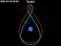
Tundra orbit (redirect from Quasi-zenith orbit)
orbits. The Sirius satellites were the only commercial satellites to use a Tundra orbit. The Japanese Quasi-Zenith Satellite System uses a geosynchronous...
18 KB (1,850 words) - 04:02, 25 May 2025
GNSS augmentation (redirect from Satellite Based Augmentation System)
Infrastructure and Transport Japan Civil Aviation Bureau (JCAB). The Quasi-Zenith Satellite System (QZSS), operated by Japan, started initial operations in November...
15 KB (1,588 words) - 13:54, 20 April 2025
Geosynchronous orbit (category Satellite broadcasting)
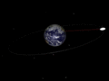
strength in the northern US and Canada. The Quasi-Zenith Satellite System (QZSS) is a four-satellite system that operates in a geosynchronous orbit at...
33 KB (3,236 words) - 12:26, 4 June 2025
GNSS applications (category Satellite navigation)
Navigation Satellite System (GNSS) receivers, using the GPS, GLONASS, Galileo or BeiDou system, are used in many applications. The first systems were developed...
18 KB (2,328 words) - 21:30, 17 March 2025

Moon (redirect from Luna (satellite))
the contiguous United States). Within the Solar System, it is the largest and most massive satellite in relation to its parent planet, the fifth-largest...
270 KB (26,422 words) - 20:51, 7 June 2025
JAXA (section Satellites for other agencies)
(Michibiki-1), the first satellite of the Quasi Zenith Satellite System (QZSS), a subsystem of the global positioning system (GPS). Three more followed...
68 KB (7,629 words) - 14:56, 20 March 2025
BeiDou (redirect from Beidou satellite navigation system)
Navigation Satellite System (BDS; Chinese: 北斗卫星导航系统; pinyin: běidǒu wèixīng dǎoháng xìtǒng) is a satellite-based radio navigation system owned and operated...
68 KB (5,866 words) - 01:18, 2 June 2025
Galileo is a global navigation satellite system (GNSS) created by the European Union through the European Space Agency (ESA) and operated by the European...
104 KB (10,186 words) - 08:22, 4 June 2025
Retrieved 13 December 2024. "Launch Result of MICHIBIKI No. 6, Quasi-Zenith Satellite System (QZS-6) aboard the 5th H3 Launch Vehicle (H3 F5)". JAXA. 2 February...
121 KB (2,494 words) - 14:18, 4 June 2025

Geodesy (section Coordinate systems in space)
because GPS satellites orbit about the geocenter that this point becomes naturally the origin of a coordinate system defined by satellite geodetic means...
38 KB (4,261 words) - 06:28, 6 May 2025

GPS Block IIIF (category Global Positioning System)
BeiDou Navigation Satellite System BeiDou-2 (COMPASS) navigation system Galileo (satellite navigation) GLONASS Quasi-Zenith Satellite System "GPS-3F (Navstar-3F)"...
41 KB (3,141 words) - 18:19, 6 June 2025

Satellite geodesy is geodesy by means of artificial satellites—the measurement of the form and dimensions of Earth, the location of objects on its surface...
21 KB (2,338 words) - 10:15, 25 November 2024

GPS Block IIF (category Global Positioning System)
BeiDou-2 (COMPASS) navigation system Galileo (satellite navigation) GLONASS Quasi-Zenith Satellite System "Global Positioning System". Boeing. Retrieved 6 May...
16 KB (775 words) - 11:30, 9 May 2025
Civil Aviation Organization (ICAO) calls this type of system a satellite-based augmentation system (SBAS). Europe and Asia are developing their own SBASs:...
42 KB (4,012 words) - 16:26, 17 March 2025

GPS signals (category Global Positioning System)
GPS signals are broadcast by Global Positioning System satellites to enable satellite navigation. Using these signals, receivers on or near the Earth's...
75 KB (10,651 words) - 13:31, 4 June 2025

mass. Its most common use is in tracking the orbits of satellites and in satellite navigation systems for measuring locations on the surface of the Earth...
9 KB (912 words) - 16:39, 14 December 2024
TCL 10 5G (category Android (operating system) devices)
A-GPS, BeiDou, Galileo, Global Navigation Satellite System, GPS (GPS L1+L5 support), Quasi-Zenith Satellite System, accelerometer, E-Compass, gyro sensor...
9 KB (882 words) - 22:16, 22 December 2024

The Universal Transverse Mercator (UTM) is a map projection system for assigning coordinates to locations on the surface of the Earth. Like the traditional...
18 KB (2,858 words) - 13:14, 29 May 2025

Geodetic datum (redirect from Geodetic Coordinate System)
developed for use in satellite navigation systems, especially the World Geodetic System (WGS 84) used in the U.S. global positioning system (GPS), and the International...
32 KB (3,377 words) - 03:19, 15 May 2025
the MKRC Legenda system, is a Soviet satellite targeting system mated to the SS-N-19 missile. It consisted of the US-P SIGINT satellites and the US-A Radar...
2 KB (173 words) - 03:31, 19 January 2025

H-IIA (category Expendable space launch systems)
NASASpaceflight. Retrieved 17 May 2010. "New Launch Day of the First Quasi-Zenith Satellite 'MICHIBIKI' by H-IIA Launch Vehicle No. 18". JAXA. Chris Bergin...
24 KB (1,003 words) - 03:38, 4 June 2025