
The San Francisco Transbay Terminal was a transportation complex in San Francisco, California, United States, roughly in the center of the rectangle bounded...
32 KB (3,090 words) - 23:32, 26 April 2025
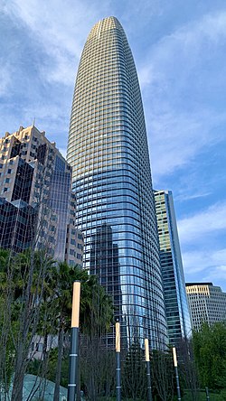
Salesforce Tower (redirect from Transbay Tower)
Center. The plan was adopted by the city in 2005. In 2011, the San Francisco Transbay Terminal was completely demolished, beginning the plan, and in 2013...
27 KB (2,421 words) - 10:12, 8 January 2025
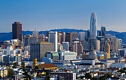
Financial District in San Francisco, California. The new transit center replaced the since-demolished San Francisco Transbay Terminal, and new skyscrapers...
24 KB (1,868 words) - 20:19, 20 January 2025
publish the 1984 San Francisco Terminal Relocation Study, which called for a below-grade alignment from I-280 and Sixth to the Transbay Terminal and predicted...
59 KB (6,685 words) - 15:09, 9 February 2025

Salesforce Transit Center (redirect from Transbay Temporary Terminal)
known as the Transbay Transit Center, is a transit center in downtown San Francisco. It serves as the primary bus terminal for the San Francisco Bay Area...
62 KB (5,232 words) - 20:11, 4 May 2025

running to a new transbay terminal located in the same vicinity in San Francisco, the Salesforce Transit Center. In 1872, the San Francisco entrepreneur and...
123 KB (13,306 words) - 22:14, 16 May 2025

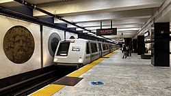
regional Rapid Transit system, connects San Francisco with the East Bay and San Jose through the underwater Transbay Tube. The line, which contains all except...
266 KB (24,399 words) - 18:46, 14 May 2025
weekday transbay service to the San Francisco Transbay Terminal. The westbound weekday morning commute from this point south towards the San Francisco–Oakland...
4 KB (390 words) - 03:12, 27 April 2025

operated in Oakland and the East Bay with a terminus in the San Francisco Transbay Terminal. Francis Marion Smith was born in Richmond, Wisconsin in 1846...
22 KB (2,468 words) - 11:46, 19 May 2025

The San Francisco Ferry Building is a terminal for ferries that travel across the San Francisco Bay, a food hall and an office building. It is located...
37 KB (3,958 words) - 23:23, 2 May 2025

"Rosewood San Francisco Announced for 550 Howard Street, SoMa, San Francisco". San Francisco YIMBY. Retrieved September 12, 2021. "Transbay Parcel F". SkyscraperPage...
103 KB (5,222 words) - 07:44, 29 March 2025

F Market & Wharves (redirect from Yellow Line (San Francisco Trolley))
in the first San Francisco Historic Trolley Festival, the service originally operated between the Castro District and the Transbay Terminal, continuing...
39 KB (3,057 words) - 18:27, 26 February 2025

at Transbay is a 43-story, 605-foot (184 m) office skyscraper in San Francisco, California. The tower is located on Block 5 of the San Francisco Transbay...
8 KB (595 words) - 19:39, 4 May 2025

larger adjacent buildings, a landmark for the Transbay Redevelopment and the southern skyline of San Francisco. Resident services include a private concierge...
33 KB (3,202 words) - 01:14, 6 January 2025

Treasure Island is a man-made island in San Francisco Bay, and a neighborhood in the City and County of San Francisco. Built in 1936–37 for the 1939 Golden...
33 KB (3,305 words) - 15:43, 5 May 2025

East Bay (redirect from East Bay (San Francisco, California))
operations. When the San Francisco–Oakland Bay Bridge opened in 1936, Key System cars could make the trip directly to the Transbay Terminal across the lower...
27 KB (2,447 words) - 16:48, 16 May 2025
development south of Market, and to help fund the replacement for the Transbay Terminal, many height limits were raised in the area. As a result, nearly all...
25 KB (2,035 words) - 14:54, 20 May 2025
The San Francisco Municipal Railway (SF Muni or Muni /ˈmjuːni/ MEW-nee) is the primary public transit system within San Francisco, California. It operates...
108 KB (9,724 words) - 02:18, 29 April 2025
serving mostly San Mateo County and County Connection connecting the suburbs of Contra Costa County; though some bus agencies operate transbay services, such...
69 KB (3,953 words) - 07:05, 10 May 2025

1989 Loma Prieta earthquake (redirect from 1989 san francisco earthquake)
rail system, which hauled commuters between the East Bay and San Francisco via the Transbay Tube, was virtually undamaged and only closed for post-earthquake...
86 KB (9,750 words) - 06:36, 17 May 2025

straining budget". San Francisco Chronicle. Retrieved December 6, 2017. "Central Subway: Visionary Project or Colossal Boondoggle?". Transbay Blog. November...
55 KB (5,015 words) - 11:36, 15 March 2025
Key System (redirect from San Francisco-Oakland Terminal Railway)
System trains to the then-new Transbay Terminal in San Francisco's downtown. The bridge railway and Transbay Terminal were shared with the Southern Pacific's...
47 KB (4,839 words) - 01:03, 8 April 2025
The San Francisco Municipal Railway (Muni) is the primary public transit system for San Francisco, California. Muni is part of the San Francisco Municipal...
31 KB (1,596 words) - 00:57, 27 April 2025

California State Route 480 (category Roads in San Francisco)
Legislative Route 68) at the west end of the San Francisco–Oakland Bay Bridge (near the Transbay Terminal). Its alignment was roughly along Lombard Street...
31 KB (3,075 words) - 01:43, 26 April 2025
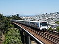
Bay Area Rapid Transit (redirect from San Francisco Bay Area Rapid Transit)
Oakland, and all but the Orange Line cross the bay through the Transbay Tube to San Francisco. All five services run every day until 9 pm; only three services...
140 KB (13,492 words) - 20:03, 4 May 2025
Trocadero Transfer (category Music venues in San Francisco)
hours dance club in operation from December 1977 to the late–1990s in San Francisco, California, U.S.. It was located at 520 4th Street at Bryant in the...
13 KB (1,471 words) - 04:32, 25 September 2024
Caltrain (redirect from CalTrain (San Francisco))
in San Francisco at 4th and King to the newly built Salesforce Transit Center, closer to the job center of San Francisco and BART, Muni, Transbay AC Transit...
181 KB (17,601 words) - 02:16, 19 May 2025
AC Transit (category Public transportation in San Francisco)
region from Richmond to Milpitas; "Transbay" regional routes, most of which operate between the East Bay and San Francisco via the Bay Bridge; and the Tempo...
37 KB (3,902 words) - 17:52, 26 April 2025

transforming the San Francisco skyline. In 2005, the Transbay Joint Powers Authority proposed to raise height limits around the new Transbay Terminal. This led...
42 KB (4,126 words) - 16:09, 14 March 2025
The history of the city of San Francisco, California, and its development as a center of maritime trade, were shaped by its location at the entrance to...
89 KB (10,312 words) - 08:57, 12 May 2025