State Highway 54 (SH 54) is a New Zealand state highway that runs across nearly all of the Manawatū District in the North Island. It runs from SH 1 at...
3 KB (359 words) - 07:01, 19 February 2024

State Highway 3 (SH 3) is one of New Zealand's eight national state highways. It serves the west coast of the country's North Island and forms a link between...
21 KB (1,778 words) - 08:11, 20 April 2024
This is a list of highways of the New Zealand state highway network and some touring routes. State highways are administered by Waka Kotahi, while all...
34 KB (320 words) - 02:39, 17 May 2024

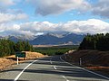
State Highway 94 is a New Zealand state highway connecting the large Southland town of Gore with one of New Zealand's most popular destinations, Milford...
22 KB (2,677 words) - 07:27, 16 May 2024
State Highway 53 (SH 53) is a New Zealand state highway linking SH 2 at Featherston with Martinborough. The highway is a 17.8 km long two lane carriageway...
2 KB (171 words) - 06:31, 19 September 2023
Japan National Route 54 National Route 54 Mexican Federal Highway 54 New Zealand State Highway 54 N54 highway (Philippines) O-54, a motorway in Turkey...
6 KB (445 words) - 23:10, 4 April 2024
on New Zealand's State Highway 1 (SH 1). All exits are unnumbered. All exits are unnumbered. All exits are unnumbered. List of New Zealand state highways...
31 KB (34 words) - 10:47, 10 April 2024
State Highway 80 (SH 80) is a South Island state highway in New Zealand. Known as Mount Cook Road, it is a tourist road between the settlements of Twizel...
2 KB (173 words) - 06:37, 19 September 2023

State Highway 29 (SH 29) is a New Zealand state highway that travels over the Kaimai Ranges linking the Bay of Plenty and Waikato regions. For most of...
14 KB (1,294 words) - 10:50, 10 April 2024

New Zealand (Māori: Aotearoa [aɔˈtɛaɾɔa]) is an island country in the southwestern Pacific Ocean. It consists of two main landmasses—the North Island...
267 KB (22,302 words) - 00:15, 9 June 2024
State Highway 67 (SH 67) is a New Zealand state highway located in the northern parts of the South Island of New Zealand. It is 51.2 km long usually on...
4 KB (396 words) - 03:42, 22 September 2023

State Highway 57 (SH 57) is a New Zealand state highway, linking State Highway 1 north of Ohau to State Highway 3 east of Ashhurst, via Levin, Shannon...
8 KB (856 words) - 21:11, 14 August 2023
State Highway 56 is a New Zealand state highway. It begins at SH 57 at Makerua and runs north-east to Palmerston North from the West. The state highway...
2 KB (138 words) - 23:00, 15 May 2022
State Highway 14 (SH 14) is a New Zealand state highway in the north of the North Island. It forms an east to west connection between SH 1 and SH 12....
3 KB (128 words) - 23:29, 31 March 2024
road (Namibia) Mahendra Highway Rijksweg 1 New Zealand State Highway 1 New Zealand State Highway 1B New Zealand State Highway 1C NIC-1 Route nationale...
20 KB (1,269 words) - 07:41, 30 May 2024

Coast of New Zealand's South Island. The township is beside the Haast River, 3 kilometres (2 mi) south of Haast Junction, on State Highway 6. The Haast...
21 KB (2,192 words) - 06:18, 10 May 2024

that began in the 1980s. New Zealand's transport infrastructure is "generally well developed." The New Zealand state highway network consists of 11,000 km...
135 KB (12,567 words) - 09:32, 7 June 2024

bridge at Waianakarua is the oldest that is still used by the New Zealand State Highway network. This bridge was dismantled stone by stone in 2004, and...
10 KB (898 words) - 22:02, 19 May 2024

Kawatiri) is a town in the West Coast region of the South Island of New Zealand. Established in 1861, it is the oldest European settlement on the West...
35 KB (3,275 words) - 07:05, 21 May 2024

seat of the Horowhenua District, in the Manawatū-Whanganui region of New Zealand's North Island. It is located east of Lake Horowhenua, around 95 km north...
20 KB (1,567 words) - 21:57, 8 June 2024

Rakarana) is a small beachside town located 48 km west of Hamilton, New Zealand on State Highway 23. It is known for its surfing, and volcanic black sand beaches...
79 KB (7,213 words) - 04:25, 27 April 2024

State Highway 49 marker State Highway 50 marker State Highway 51 marker State Highway 53 marker State Highway 54 marker State Highway 56 marker State Highway...
118 KB (10,529 words) - 23:10, 30 May 2024

town in the Rangitikei District of New Zealand. It is in a fertile farming area at the junction of State Highways 1 and 3, 28 km (17 mi) northwest of...
17 KB (1,500 words) - 04:25, 20 May 2024

of New Zealand. It is about 140 km south of Christchurch, and inland from Timaru, which is 38 km to the south. Geraldine is located on State Highway 79...
37 KB (3,449 words) - 01:25, 19 May 2024

New Zealand Herald. Archived from the original on 29 August 2021. Retrieved 29 August 2021. "Canterbury flooding: Ashburton Bridge on State Highway 1...
73 KB (6,120 words) - 01:37, 19 May 2024

Lawrence is a small town in Otago, in New Zealand's South Island. It is located on State Highway 8, the main route from Dunedin to the inland towns of...
24 KB (2,881 words) - 06:35, 15 April 2024

The climate of New Zealand is varied due to the country's diverse landscape. Most regions of New Zealand belong to the temperate zone with a maritime...
31 KB (3,530 words) - 08:19, 19 May 2024

Canterbury, on the east coast of the South Island of New Zealand. It is located on State Highway 1, approximately 112 kilometres (70 mi) north of Christchurch...
18 KB (1,591 words) - 04:16, 23 May 2024

Darfield is a town in the Selwyn District of the South Island of New Zealand. It is 35 kilometres west of Christchurch. Its population is 3,150 as of...
19 KB (1,673 words) - 05:06, 6 June 2024
service along State Highway 63 provides connections to Nelson, Murchison, Greymouth, Blenheim, Westport and Picton. The Royal New Zealand Air Force's field...
29 KB (1,487 words) - 04:22, 20 May 2024