
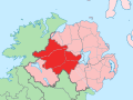
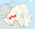
Strabane Upper (named after Strabane) is a barony in County Tyrone, Northern Ireland. It is bordered by six other baronies: Tirkeeran and Keenaght to the...
3 KB (122 words) - 13:33, 1 February 2021
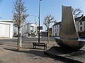
Strabane (/strəˈbæn/; from Irish An Srath Bán, meaning 'the white river-holm') is a town in County Tyrone, Northern Ireland. Strabane had a population...
43 KB (4,113 words) - 12:24, 19 July 2025
Clogher Dungannon Lower Dungannon Middle Dungannon Upper Omagh East Omagh West Strabane Lower Strabane Upper Parishes Townlands There is the possibility of...
29 KB (2,396 words) - 21:39, 9 July 2025

record for "Strabane barony". The barony was subsequently subdivided and, by 1851, had been split into Strabane Lower and Strabane Upper. Dungannon (barony)...
4 KB (338 words) - 16:02, 9 January 2025

Clogher Dungannon Lower Dungannon Middle Dungannon Upper Omagh East Omagh West Strabane Lower Strabane Upper WikiProject Northern Ireland WikiProject Ireland...
12 KB (1,003 words) - 20:16, 19 July 2025

electoral wards in the Derg district electoral area of Derry City and Strabane District Council. The other wards are Finn, Glenderg, Newtownstewart and...
22 KB (1,525 words) - 04:43, 21 July 2025

Carrigans, County Tyrone (category Barony of Strabane Upper)
Tyrone, Northern Ireland. It is situated in the historic barony of Strabane Upper and the civil parish of Cappagh and covers an area of 859 acres. The...
3 KB (156 words) - 14:42, 27 April 2022
Clogher Dungannon Lower Dungannon Middle Dungannon Upper Omagh East Omagh West Strabane Lower Strabane Upper WikiProject Northern Ireland WikiProject Ireland...
46 KB (4,146 words) - 12:26, 23 April 2025

river forms the townland of Lisnamllard in the civil parish of Cappagh (Upper Strabane portion). Both civil parishes comprise also outskirts of Omagh and some...
48 KB (4,105 words) - 00:15, 9 July 2025
Aghaboy Lower 289 Strabane Upper Bodoney Lower Gortin Aghaboy Upper 361 Strabane Upper Bodoney Lower Gortin Aghabrack 268 Strabane Lower Donaghedy Gortin...
230 KB (115 words) - 01:38, 4 July 2025

Liberties of Londonderry to the north; Tirkeeran to the north-east; Strabane Upper to the east; Omagh East to the south; and Omagh West to the south-west...
3 KB (159 words) - 14:17, 9 March 2025
Omagh West and Lurg to the west; Strabane Lower and Strabane Upper to the north; Dungannon Middle and Dungannon Upper to the east; Clogher and Tirkennedy...
3 KB (138 words) - 17:51, 28 October 2021

Speirín) are a mountain range in Northern Ireland. The range stretches from Strabane and Mullaghcarn in the west, to Slieve Gallion and the Glenshane Pass in...
8 KB (407 words) - 22:58, 4 April 2025
population of 113 people. The townland is situated in the historic barony of Strabane Upper and the civil parish of Termonmaguirk and covers an area of 1,352 acres...
3 KB (230 words) - 16:12, 27 June 2025

Clogher Dungannon Lower Dungannon Middle Dungannon Upper Omagh East Omagh West Strabane Lower Strabane Upper WikiProject Northern Ireland WikiProject Ireland...
11 KB (1,035 words) - 12:25, 19 July 2025

Clogher Dungannon Lower Dungannon Middle Dungannon Upper Omagh East Omagh West Strabane Lower Strabane Upper WikiProject Northern Ireland WikiProject Ireland...
10 KB (879 words) - 18:54, 19 July 2025
Sandholes Seskinore Shanmaghery Sion Mills Sixmilecross Spamount Stewartstown Strabane Strathroy Tamnamore Tattyreagh Trillick Tullyhogue Tullywiggan Victoria...
3 KB (190 words) - 01:37, 4 July 2025

baronies: Dungannon Upper to the south; Strabane Upper to the west; Keenaght and Coleraine to the north; Kilconway, Toome Upper, and Toome Lower to the...
12 KB (1,115 words) - 20:22, 19 June 2025

Strabane Lower and the civil parish of Ardstraw. In the 2021 Census it had a population of 1,414 people. It lies within the Derry City and Strabane District...
11 KB (902 words) - 21:36, 20 July 2025

baronies: Dungannon Middle to the south; Loughinsholin to the north; Strabane Upper to the north-west; and Omagh East to the south-west. Ardboe Coagh Cookstown...
4 KB (176 words) - 18:34, 16 February 2024

Clogher Dungannon Lower Dungannon Middle Dungannon Upper Omagh East Omagh West Strabane Lower Strabane Upper WikiProject Northern Ireland WikiProject Ireland...
11 KB (1,112 words) - 07:49, 28 June 2025

baronies: Keenaght to the east; Strabane Lower to the south-east; North West Liberties of Londonderry to the west; and Strabane Upper to the south. Tirkeeran...
7 KB (619 words) - 03:51, 6 February 2025

£15,000 compensation for the loss of the electoral rights of Augher and Strabane – the other borough he owned. Also abolished at the same time was the civil...
8 KB (747 words) - 16:17, 27 June 2025

Clogher Dungannon Lower Dungannon Middle Dungannon Upper Omagh East Omagh West Strabane Lower Strabane Upper WikiProject Northern Ireland WikiProject Ireland...
4 KB (432 words) - 16:55, 27 June 2025

the 2021 Census, it had a population of 242 people. It lies within the Strabane District Council area. It is roughly 10 kilometres (6 mi) south-west of...
3 KB (318 words) - 15:49, 27 June 2025

Clogher Dungannon Lower Dungannon Middle Dungannon Upper Omagh East Omagh West Strabane Lower Strabane Upper WikiProject Northern Ireland WikiProject Ireland...
8 KB (764 words) - 16:33, 27 June 2025

Northern Ireland. It is situated in the barony of Strabane Upper and the civil parish of Bodoney Upper and covers an area of 937 acres. The name derives...
1 KB (112 words) - 13:20, 9 February 2025

Donemana (category Barony of Strabane Lower)
Tyrone, Northern Ireland. It is 7 miles or 11 kilometres north-east of Strabane, on the banks of the Burn Dennett and at the foothills of the Sperrins...
20 KB (1,290 words) - 00:49, 1 July 2025
Clogher Dungannon Lower Dungannon Middle Dungannon Upper Omagh East Omagh West Strabane Lower Strabane Upper WikiProject Northern Ireland WikiProject Ireland...
3 KB (238 words) - 01:36, 4 July 2025
Cookstown townland itself is situated in the historic barony of Dungannon Upper and the civil parish of Derryloran and covers an area of 217 acres. The...
39 KB (3,185 words) - 05:40, 28 June 2025