Streamflow, or channel runoff, is the flow of water in streams and other channels, and is a major element of the water cycle. It is one runoff component...
15 KB (2,086 words) - 01:59, 8 August 2024

States, with over 7400 stream gauges. Real-time streamflow data is available online. the National Streamflow Information Program National Water-Quality Assessment...
35 KB (3,595 words) - 08:13, 29 April 2025
fluvial hydrologist studying natural river systems may define discharge as streamflow, whereas an engineer operating a reservoir system may equate it with outflow...
10 KB (1,460 words) - 16:53, 20 April 2025

measurements of streamflow discharge are made by the technician or hydrologist at a variety of stages. For each discrete determination of streamflow discharge...
14 KB (1,647 words) - 09:58, 5 February 2024
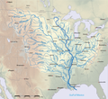
list of rivers in the continental United States by average discharge (streamflow) in cubic feet per second. All rivers with average discharge more than...
15 KB (495 words) - 03:11, 6 December 2024
runoff or overland flow. Once in a watercourse, runoff is referred to as streamflow, channel runoff, or river runoff. Urban runoff is surface runoff created...
832 bytes (1,928 words) - 18:38, 20 October 2023
Mississippi River floods of 2019 (section Streamflow)
Flooding in the Mississippi River Basin during the winter, spring, and summer of 2019 caused at least 12 deaths and economic losses in 19 states totaling...
40 KB (4,271 words) - 06:57, 14 April 2025

eastern part of Democratic Republic of the Congo. It provides the greatest streamflow to the Congo River, while the source of the Congo is recognized as the...
5 KB (590 words) - 14:03, 1 May 2025

the x-axis. Users can choose to plot streamflow (actual values or log values), streamflow percentile, or streamflow class (from 1, for low flow, to 7 for...
13 KB (1,752 words) - 16:45, 20 April 2025

October 5, 2021. Retrieved October 6, 2021. Median of the 14,610 daily streamflows recorded by the USGS for the period 1967–2006. "The True Utmost Reaches...
162 KB (14,206 words) - 00:32, 17 April 2025

Fresh water (section Minimum streamflow)
An important concern for hydrological ecosystems is securing minimum streamflow, especially preserving and restoring instream water allocations. Fresh...
22 KB (3,435 words) - 15:35, 8 March 2025
Brea Creek (section Streamflow)
Creek, the next major tributary. From 1932 to 1969, the USGS operated two streamflow gauges on Brea Creek, one at the mouth and one at Brea Reservoir. The...
9 KB (641 words) - 18:31, 5 March 2025

Bass Lake, formerly known as Crane Valley Reservoir, is a man-made lake located in Madera County, California, within the Sierra National Forest, approximately...
9 KB (882 words) - 22:27, 16 April 2025

Banias River (section Course and streamflow)
Stream (right), with a total drainage area of 158 km2. The total annual streamflow of the river comes to 106 million m3. The banks of the river abound in...
10 KB (921 words) - 03:18, 31 January 2025
USA: Peak Streamflow". nwis.waterdata.usgs.gov. Archived from the original on July 8, 2022. Retrieved July 8, 2022. "USGS WaterWatch -- Streamflow conditions"...
37 KB (3,299 words) - 05:56, 14 September 2024

River. (However, by volume of water, the Lualaba River provides a greater streamflow to the Congo.) The Chambeshi rises as a stream in the mountains of northeast...
4 KB (223 words) - 23:45, 6 November 2024

environmental water cycle data (also hydrological data), such as rainfall and streamflow. These studies have yielded controversial results, because the methods...
115 KB (13,052 words) - 21:28, 9 April 2025
(disambiguation) Floe (disambiguation) Floh (disambiguation) Flou (disambiguation) Streamflow, or channel runoff, the flow of water in streams, rivers, and other channels...
4 KB (503 words) - 02:39, 14 April 2025

Peachtree Creek (section Streamflow and flooding)
Peachtree Creek is a major stream in Atlanta. It flows for 7.5 miles (12.1 km) almost due west into the Chattahoochee River just south of Vinings. Peachtree...
8 KB (1,102 words) - 04:01, 4 February 2025

ground as surface runoff. A portion of this runoff enters rivers, with streamflow moving water towards the oceans. Runoff and water emerging from the ground...
43 KB (5,246 words) - 22:19, 1 May 2025
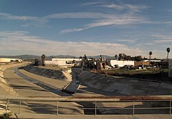
high flows exceeding ten thousand cfs. For Brea Creek streamflow data see Brea Creek#Streamflow. For Fullerton Creek, the USGS operated two stream gauges...
18 KB (1,643 words) - 18:31, 5 March 2025

such as extratropical cyclones, are caused by instabilities of the jet streamflow. Because Earth's axis is tilted relative to its orbital plane (called...
49 KB (4,809 words) - 17:29, 17 April 2025

Trinity River (California) (section Streamflow)
Trinity River above Coffee Creek near Trinity Center, CA: Instantaneous streamflow data". National Water Information System. U.S. Geological Survey. Retrieved...
82 KB (9,262 words) - 06:15, 4 February 2025

for 2008–2015 from the Bureau of Meteorology’s Karnet site. This caused streamflow into the dam to drop by 58%, nearly half between 1989 and 2008. In 2015...
18 KB (2,198 words) - 01:32, 17 November 2024

Sol Duc River (section Streamflow)
Quileute name, /só:liɬt'aqʷ/, meaning "sparkling waters". The discharge, or streamflow of the Sol Duc River has considerable seasonal variation. According to...
17 KB (2,070 words) - 00:48, 14 April 2025

Zhang; Jianping, Gan; Qichun, Yang (2024). "Spatiotemporal variability of streamflow in the Pearl River Basin: Controls of land surface processes and atmospheric...
11 KB (627 words) - 22:17, 15 April 2025

South Fork Trinity River (section Streamflow)
Coordinated Resources Management Planning Group. Retrieved 2009-07-29. USGS streamflow data for four stream gauges along the South Fork "Six Rivers National...
23 KB (2,658 words) - 05:13, 4 February 2025
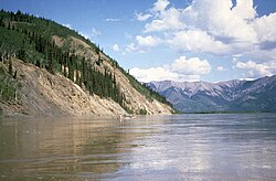
Through the Yukon River Basin". 2008. "USGS Surface Water for USA: Peak Streamflow". nwis.waterdata.usgs.gov. Marsh Lake Fall-Winter Storage Concept Hydrology...
49 KB (3,810 words) - 23:42, 5 March 2025

Oso Creek (section Streamflow)
Oso Creek is an approximately 13.5-mile (21.7 km) tributary of Arroyo Trabuco in southern Orange County in the U.S. state of California. Draining about...
15 KB (1,521 words) - 18:32, 5 March 2025
discharge and sustained or fair-weather runoff) is the portion of the streamflow that is sustained between precipitation events, fed to streams by delayed...
9 KB (1,016 words) - 04:12, 22 July 2024