
Swisstopo is the official name for the Swiss Federal Office of Topography, Switzerland's national mapping agency. The current name was made official in...
17 KB (2,183 words) - 12:11, 5 February 2025

National Maps of Switzerland (redirect from Swisstopo maps)
Switzerland, also referred to as the Swisstopo maps, are a set of official map series designed, edited and distributed by Swisstopo, the Swiss Federal Office of...
4 KB (426 words) - 13:09, 24 February 2025
Liechtenstein for maps and surveying by the Swiss Federal Office of Topography (Swisstopo). A first coordinate system was introduced in 1903 under the name LV03...
7 KB (968 words) - 02:16, 21 January 2025

The Western Lyskamm (German: Liskamm Westgipfel) is a subsidiary peak of the Lyskamm. Swisstopo map v t e v t e...
1 KB (21 words) - 23:34, 5 April 2025

Titlis from Pilatus List of mountains of Switzerland Retrieved from the Swisstopo topographic maps [1] and Google Earth. The key col is the Susten Pass...
8 KB (810 words) - 10:50, 27 October 2024

above the Morteratsch Glacier View from Diavolezza Retrieved from the Swisstopo topographic maps. The key col is the Maloja Pass (1,812 m). Retrieved...
12 KB (1,310 words) - 13:24, 26 October 2024

https://web.archive.org/web/20120607113752/http://www.swisstopo.admin.ch/internet/swisstopo/en/home/topics/knowledge/center_ch.html https://web.archive...
2 KB (203 words) - 07:31, 13 May 2024

Map 1:25 000. Berne, Switzerland: Swiss Federal Office of Topography – swisstopo. 2012. ISBN 978-3-302-01208-7. Retrieved 2016-08-21. "Harder Kulm". Jungfrau...
3 KB (236 words) - 14:47, 4 May 2024

Eggstock (2,436 m) and the Vorderer Eggstock (2,449 m). Retrieved from the Swisstopo topographic maps. The key col is located west of the summit at 2,359 metres...
2 KB (105 words) - 17:22, 16 April 2022
is renamed as the Swiss Federal Office of Topography in 1979, with the swisstopo.ch website online since 1997. The first systematic geographical description...
15 KB (1,944 words) - 16:57, 19 July 2021

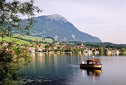
the exit in Geneva According to the Swiss Federal Office of Topography, Swisstopo, Lac de Genève designates that part of the Petit Lac which lies within...
40 KB (2,893 words) - 17:47, 17 May 2025

mountains of Switzerland accessible by public transport Retrieved from the Swisstopo topographic maps and Google Earth. The key col is located east of the...
4 KB (377 words) - 07:18, 26 October 2024

List of highest road passes in Switzerland Albula Pass, Swisstopo topographic maps Swisstopo maps, official maps of Switzerland by the Swiss government...
4 KB (340 words) - 02:55, 28 October 2024

"Topographic map of Piz Bernina". opentopomap.org. Retrieved 3 July 2023. Swisstopo Wikimedia Commons has media related to Bernina. Visual day-by-day narrative...
7 KB (272 words) - 12:35, 9 April 2025

Switzerland named after people Tourism in Switzerland Retrieved from the Swisstopo topographic maps. The key col is the Glaubenberg Pass (1,543 m). Retrieved...
12 KB (811 words) - 17:53, 18 March 2025
Uri (3,500 m) is located 600 m west of the summit. Retrieved from the Swisstopo topographic maps and Google Earth. The key col is located south of the...
2 KB (82 words) - 16:20, 15 May 2022

Switzerland List of mountains of Switzerland above 3000 m Retrieved from the Swisstopo topographic maps. The key col is the Nördliches Eigerjoch (3,605 m). Retrieved...
38 KB (4,857 words) - 17:45, 6 May 2025

summit. "Piz Lad". jo-albis.ch. Retrieved 2010-06-17. Retrieved from the Swisstopo topographic maps. The key col is the Forcola di Dentro (2,576 m). Piz...
2 KB (73 words) - 16:19, 14 July 2024

"Search.ch" (Map). Schulhaus Hofern. Cartography by search.ch, TomTom, swisstopo, osm. Zurich, Switzerland: Tamedia AG. Retrieved 2015-04-23. "Zentrum...
17 KB (1,525 words) - 10:24, 2 May 2025

transport Retrieved from the Swisstopo topographic maps. The key col is located at Ächerli (1,398 m). Retrieved from the Swisstopo topographic maps. Two intermediate...
8 KB (896 words) - 09:44, 18 November 2024

mountains of Switzerland accessible by public transport Retrieved from the Swisstopo topographic maps. The key col is the Furggeli (1,732 m). Media related...
2 KB (91 words) - 18:13, 7 July 2024

all sides. Most of the massif is covered by forests. Retrieved from the Swisstopo topographic maps. The key col is the Schindelbergpass (1,180 m). Retrieved...
2 KB (105 words) - 20:46, 12 May 2022
Geological Survey of Sweden Geoscience Australia Saudi Geological Survey Swisstopo (Switzerland) United States Geological Survey (USGS) Individual states...
4 KB (502 words) - 14:39, 29 August 2024
of Switzerland accessible by public transport Tourism in Switzerland Swisstopo maps Retrieved from Google Earth. The nearest point of higher elevation...
10 KB (1,052 words) - 19:27, 16 February 2025
from the Swisstopo topographic maps. The key col is located between Estavayer-le-Lac and Bussy at 480 metres. Retrieved from the Swisstopo topographic...
2 KB (126 words) - 17:53, 28 March 2023
supported on a brick base extending in three directions. Retrieved from the Swisstopo topographic maps. The key col is the Ijesfürggli (2,348 m). "Naafkopf :...
2 KB (78 words) - 20:59, 17 December 2023

Bern Parent range Bernese Alps Topo map Swiss Federal Office of Topography swisstopo Geology Mountain type mountain ridge Climbing Easiest route Railway...
6 KB (539 words) - 05:09, 28 September 2021

four-thousanders List of mountains of Valais High Alps Retrieved from the Swisstopo topographic maps. The key col is the Great St Bernard Pass (2,469 m) Retrieved...
35 KB (4,621 words) - 21:52, 2 May 2025

side consists of a 600 metres cliff named Wandflue. Retrieved from the Swisstopo topographic maps. The key col is located north of the mountain at 3,474...
1 KB (75 words) - 03:49, 21 October 2021

Rosa Massif. List of Italian regions by highest point Retrieved from the Swisstopo topographic maps. "Grenzgipfel". Peakbagger.com. Retrieved 23 February...
3 KB (173 words) - 09:40, 1 November 2024