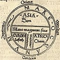
A T and O map or O–T or T–O map (orbis terrarum, orb or circle of the lands; with the letter T inside an O), also known as an Isidoran map, is a type of...
18 KB (2,340 words) - 17:14, 21 April 2025
Memory-mapped I/O (MMIO) and port-mapped I/O (PMIO) are two complementary methods of performing input/output (I/O) between the central processing unit...
17 KB (2,288 words) - 01:44, 18 November 2024
Anaximander (610–546 BC) World map according to Posidonius (150–130 BC), drawn in 1628 Ideal reconstruction of medieval T-and-O maps (from Meyers Konversationslexikon...
9 KB (897 words) - 04:23, 3 June 2025
hands on either side and his feet at the bottom. The Map was a greatly elaborated version of the medieval tripartite or T and O map; it was centred on Jerusalem...
73 KB (8,596 words) - 22:27, 18 May 2025

lower probability. Second, t-SNE defines a similar probability distribution over the points in the low-dimensional map, and it minimizes the Kullback–Leibler...
15 KB (2,065 words) - 01:25, 24 May 2025

map. In the Middle Ages many Eurasian maps, including the T and O maps, were drawn with east at the top (meaning that the direction "up" on the map is...
36 KB (4,374 words) - 15:52, 7 June 2025

northern hemisphere." Other maps with non-standard orientation include T and O maps, polar maps, and Dymaxion maps. Map projection North–South divide...
12 KB (1,277 words) - 18:55, 28 March 2025
map (T and O), centered on Jerusalem with east at the top. The head of Christ was depicted at the top of the map, with his hands on either side and his...
5 KB (500 words) - 19:18, 26 March 2025
Mittelalters. The "upside-down-T in a circle" symbol on the spine and cover is an artistic interpretation of the T and O map, which was first described in...
2 KB (226 words) - 15:47, 4 November 2023

Continent (section Definitions and application)
T and O maps, with the T representing the waters dividing the three continents. By the middle of the 18th century, "the fashion of dividing Asia and Africa...
90 KB (8,844 words) - 00:33, 26 May 2025
Cartography of Europe (redirect from Map of italy)
adhered to in medieval T and O maps. Ptolemy's world map of the 2nd century already had a reasonably precise description of southern and western Europe, but...
2 KB (229 words) - 00:47, 28 May 2025
For the circle of lands, see T and O map. Circle Map is a composition for orchestra and electronics by the Finnish composer Kaija Saariaho. The work was...
4 KB (448 words) - 16:16, 22 January 2025
Google Maps is a web mapping platform and consumer application offered by Google. It offers satellite imagery, aerial photography, street maps, 360° interactive...
164 KB (14,285 words) - 07:27, 11 June 2025
Contents: A–L (previous page) M N O P Q R S T U V W X Y Z See also References Mary MacPherran (portrayed by Jameela Jamil), also known as Titania, is...
255 KB (27,313 words) - 17:32, 13 June 2025
Glossary of engineering: M–Z (section O)
page for glossaries of specific fields of engineering. Contents: M N O P Q R S T U V W X-Z See also References External links Macaulay's method (The double...
251 KB (31,183 words) - 23:48, 11 June 2025

Pictorial maps (also known as illustrated maps, panoramic maps, perspective maps, bird's-eye view maps, and geopictorial maps) depict a given territory...
13 KB (1,602 words) - 21:06, 4 April 2025
Circle containing four or more spokes T and O map – Type of medieval world map Astrological sign#Polarity and the four elements – one of the twelve 30°...
7 KB (742 words) - 06:03, 26 May 2025

Isidore of Seville. The V-in-square map is named from its basic shape, by analogy with the T and O map. It is a square map divided into three parts by a V...
10 KB (964 words) - 19:06, 26 March 2025
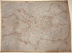
Portolan chart (redirect from Portolan map)
periplus or pilot book with the decorative illustrations of a medieval T and O map. In addition, the charts provided realistic depictions of shores. They...
19 KB (2,309 words) - 12:34, 28 May 2025
Cartographic propaganda (redirect from Persuasive map)
as maps intended primarily to influence opinions or beliefs – to send a message – rather than to communicate geographic information. The T-O map is a...
33 KB (3,907 words) - 07:30, 13 June 2025
List of emoticons (redirect from O/\o)
Emoticons / Emoji (✿◕‿◕)(ʘ‿ʘ✿) - Cute Kaomoji ❀". Retrieved 2021-11-25. "(=ʘᆽʘ=)∫ Lennyfaces". lennyfac.es. Retrieved 2021-03-22. "List of emoticons". Microsoft...
44 KB (1,620 words) - 15:43, 11 June 2025
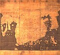
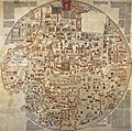
Gangnido (redirect from Kangnido Map)
Ji Do ("Map of Integrated Lands and Regions of Historical Countries and Capitals (of China)"), often abbreviated as Kangnido, is a world map completed...
24 KB (3,459 words) - 18:40, 26 March 2025

the design of the Babylonian map of the world may have lived on in the T and O maps of the European Middle Ages. Babylon Sippar List of cities of the ancient...
17 KB (1,692 words) - 19:17, 24 May 2025

Globus cruciger (redirect from Globe and cross)
Ball and the Cross Holy Hand Grenade of Antioch Monde (crown) Earth symbol Celestial spheres T and O map Apfelgroschen – coin depicting the orb and cross...
11 KB (1,226 words) - 06:00, 7 June 2025

Cartography of Africa (redirect from Map of africa)
of the Mediterranean, an arrangement that was adhered to in medieval T and O maps. The only part of Africa well known in antiquity was the coast of North...
4 KB (419 words) - 05:26, 5 August 2024

Dyadic transformation (redirect from Dyadic map)
as the dyadic map, bit shift map, 2x mod 1 map, Bernoulli map, doubling map or sawtooth map) is the mapping (i.e., recurrence relation) T : [ 0 , 1 ) →...
24 KB (4,718 words) - 15:26, 6 January 2025

Don (river) (section Dams and canals)
Temernik Don goat And Quiet Flows the Don by Mikhail Sholokov Rostov railway drawbridge Later works, as the 7th-century T and O map, also depicts the...
20 KB (1,882 words) - 21:41, 7 June 2025
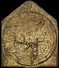
Hereford Mappa Mundi (redirect from Hereford map)
featuring heaven, hell and the path to salvation. Dating from c. 1300 AD, the map is drawn in a form deriving from the T and O pattern. It is displayed...
36 KB (4,695 words) - 11:31, 24 May 2025