
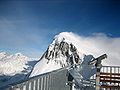
The Weissfluh is a mountain of the Plessur Alps, located above Davos in the canton of Graubünden. It is part of a ski area and the summit is served by...
2 KB (94 words) - 22:22, 29 November 2024
Dübendorf Alpnach Locarno Emmen Payerne Meiringen Pilatus Scopi Weisshorn Weissfluh During the past 35 years, Swiss military and civil airspace control depended...
64 KB (5,893 words) - 22:40, 25 June 2025
Radar Station Steinmandl Radar Station Dübendorf Pilatus Scopi Weisshorn Weissfluh Swiss Air Force - FLORAKO system: Air Defence & Direction Center, at Dübendorf...
85 KB (5,504 words) - 22:17, 17 July 2025

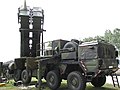
Swiss francs. The four radar sites Mount Pilatus, Scopi, Weisshorn and Weissfluh are classified and therefore not publicly available. Thales Raytheon Systems...
10 KB (1,213 words) - 06:07, 28 March 2024
radar, PESA 2004 4 4 radar sites, Mount Pilatus, Scopi, Weisshorn and Weissfluh made by Thales Raytheon Systems. Modernised in 2022. Feeding the FLORAK0...
155 KB (4,561 words) - 14:53, 22 July 2025

95917°N 9.38667°E / 46.95917; 9.38667 Glarus Alps St. Gallen 1864 260 174 Weissfluh 2,843 9,327 497 1,631 46°50′06″N 09°47′43″E / 46.83500°N 9.79528°E...
112 KB (1,337 words) - 21:15, 20 July 2024

The Weissfluhjoch (2,693 m (8,835 ft)) is a summit southeast of the Weissfluh (2,843 m (9,327 ft)) situated in the Plessur Range in Graubünden, Switzerland...
7 KB (207 words) - 09:00, 13 December 2024
Dübendorf Alpnach Locarno Emmen Payerne Meiringen Pilatus Scopi Weisshorn Weissfluh Air Force (German: Luftwaffe), in Bern Air Force Staff (German: Luftwaffenstab)...
75 KB (6,186 words) - 15:01, 19 April 2025
H-Alpes/Turin FR/IT 703 Weissfluh 2843 497 46°50′06″N 09°47′43″E / 46.83500°N 9.79528°E / 46.83500; 9.79528 (703. Weissfluh (2843 m)) Plessur Alps...
94 KB (827 words) - 18:10, 4 August 2024
46°58′13″N 10°20′03″E / 46.97028°N 10.33417°E / 46.97028; 10.33417 Weissfluh 2843 497 2820 Cable car Graubünden 46°50′07″N 09°47′39″E / 46.83528°N...
14 KB (294 words) - 16:30, 11 May 2025

Highest point Elevation 2,709 m (8,888 ft) Prominence 113 m (371 ft) Parent peak Weissfluh Coordinates 46°49′04.4″N 9°48′14.2″E / 46.817889°N 9.803944°E / 46...
1 KB (47 words) - 17:58, 16 April 2022

overlooking Langwies in the canton of Graubünden. It lies west of the Weissfluh. Retrieved from the Swisstopo topographic maps. The key col is located...
1 KB (46 words) - 18:04, 16 April 2022

Highest point Elevation 2,557 m (8,389 ft) Prominence 122 m (400 ft) Parent peak Weissfluh Coordinates 46°51′32.6″N 9°49′34.6″E / 46.859056°N 9.826278°E / 46...
1 KB (51 words) - 17:18, 16 April 2022
46.90056°N 10.37861°E / 46.90056; 10.37861 Samnaun Alps Graubünden 54 Weissfluh 2843 11.5 497 46°50′07″N 09°47′40″E / 46.83528°N 9.79444°E / 46.83528;...
9 KB (124 words) - 14:44, 1 May 2024

10°06′45″E / 46.32278°N 10.11250°E / 46.32278; 10.11250 Livigno Alps Bernina Weissfluh 2843 497 46°50′06″N 09°47′43″E / 46.83500°N 9.79528°E / 46.83500; 9...
27 KB (336 words) - 16:08, 5 May 2024