
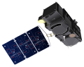
The Cyclone Global Navigation Satellite System (CYGNSS) is a space-based system developed by the University of Michigan and Southwest Research Institute...
27 KB (2,543 words) - 18:31, 3 November 2024

Indian Regional Navigation Satellite System (IRNSS), with an operational name of NavIC (acronym for Navigation with Indian Constellation; also, nāvik 'sailor'...
63 KB (5,276 words) - 11:26, 20 March 2025
pages with titles containing Cygnus Cyclone Global Navigation Satellite System (CYGNSS), a hurricane study satellite constellation in development by NASA...
2 KB (291 words) - 10:14, 3 March 2025

observation satellites are Earth-orbiting spacecraft with sensors used to collect imagery and measurements of the surface of the earth. These satellites are used...
39 KB (1,232 words) - 04:38, 23 March 2025
The Global Positioning System (GPS) is a satellite-based hyperbolic navigation system owned by the United States Space Force and operated by Mission Delta...
185 KB (19,124 words) - 03:18, 9 April 2025
augmented navigation (GAGAN) is an implementation of a regional satellite-based augmentation system (SBAS) by the Government of India. It is a system to improve...
24 KB (2,667 words) - 03:41, 24 March 2025

GNSS reflectometry (category Satellite navigation)
measurements from the reflections from the Earth of navigation signals from Global Navigation Satellite Systems such as GPS. The idea of using reflected GNSS...
10 KB (1,149 words) - 04:42, 14 March 2025
Ridley is a winner of NASA Group Achievement Award (2006). Cyclone Global Navigation Satellite System "Aaron Ridley". scholar.google.com. "Aaron Ridley". clasp...
3 KB (56 words) - 22:36, 21 April 2025

wind speed measurements in the eye of the storm. The Cyclone Global Navigation Satellite System, launched by NASA in 2016, is expected to provide much...
22 KB (2,666 words) - 08:12, 8 January 2025
Scatterometer (category Satellite meteorology)
onboard Metop-A. The Cyclone Global Navigation Satellite System (CYGNSS), launched in 2016, is a constellation of eight small satellites utilizing a bistatic...
12 KB (1,457 words) - 06:14, 6 February 2025

Geostationary orbit (redirect from Geostationary satellite)
located. Weather satellites are also placed in this orbit for real-time monitoring and data collection, as are navigation satellites in order to provide...
49 KB (4,892 words) - 08:52, 12 March 2025

Tropospheric Emissions: Monitoring of Pollution (category Satellite meteorology)
Cyclone Global Navigation Satellite System (CYGNSS), Ecosystem Spaceborne Thermal Radiometer Experiment on Space Station (ECOSTRESS), and the Global Ecosystem...
8 KB (688 words) - 21:18, 21 January 2024

Northrop Grumman Pegasus (category Expendable space launch systems)
"C/NOFS (Communication/Navigation Outage Forecast System)". Retrieved 31 March 2020. "IBEX - eoPortal Directory - Satellite Missions". directory.eoportal...
50 KB (3,010 words) - 01:13, 19 April 2025

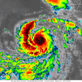
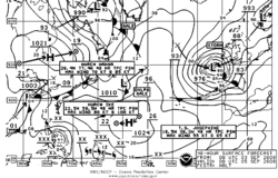
The picture shows many weather systems, featuring a Shapyro–Keyser cyclone near to the center of the image. Cyclone Sixteen (16B) can be seen in the...
34 KB (3,479 words) - 00:58, 2 May 2025
Garmin (category Satellite navigation)
Southampton FC in a global partnership. Garmin's European head office is located in Southampton. Companies portal Automotive navigation system Comparison of...
83 KB (7,408 words) - 17:02, 17 April 2025

Polarimeter to Unify the Corona and Heliosphere (redirect from Punch satellite)
and accurate deep field imaging. The mission builds on Cyclone Global Navigation Satellite System (CYGNSS) experience with smallsat constellations. To accomplish...
12 KB (1,173 words) - 18:29, 17 April 2025
Rapid intensification (category Tropical cyclone meteorology)
Processes (GRIP)". GHRC. NASA. Retrieved 5 November 2023. "Cyclone Global Navigation Satellite System (CYGNSS)" (PDF). Ann Arbor, Michigan: University of Michigan...
47 KB (4,841 words) - 02:46, 8 October 2024

JPL and the development of reflectometry technologies for Global navigation satellite systems. She is the chair of the Board of the Italian Scientists...
11 KB (777 words) - 21:25, 9 March 2025

Delta I-class submarines carry the Tobol-B navigation system and the Cyclone-B satellite navigation system. After construction was authorized in 1965...
29 KB (1,920 words) - 22:22, 19 March 2025
Earth's oceans. Mariners have had rules of thumb regarding the navigation around tropical cyclones for many years, dividing a storm into halves and sailing...
40 KB (4,599 words) - 11:40, 22 June 2024

look for potential tropical cyclones, in the years before the continuous weather satellite era. Since regular satellite surveillance began, hurricane...
57 KB (3,115 words) - 07:36, 8 May 2025
Environmental Satellite (GOES) (a program of the US) geostatistics geostrophic wind Global Atmosphere Watch (GAW) Global Forecast System (GFS) global warming...
27 KB (2,806 words) - 22:30, 15 April 2025

Inuit navigation techniques are those navigation skills used for thousands of years by the Inuit, a group of culturally similar indigenous peoples who...
12 KB (1,294 words) - 09:04, 2 November 2024
covers most artificial satellites built and operated by the Republic of India. India has been successfully launching satellites of various types from 1975...
296 KB (8,865 words) - 14:34, 23 March 2025

Hurricane Helene (redirect from Potential Tropical Cyclone Nine (2024))
Hurricane Helene (/hɛˈliːn/ heh-LEEN) was a deadly and devastating tropical cyclone that caused widespread catastrophic damage and numerous fatalities across...
227 KB (19,015 words) - 19:24, 5 May 2025

decision support systems – Computerised aid to land use decisions Global Navigation Satellite Systems (GNSS) – Various satellite navigation systems Hydrology...
22 KB (2,679 words) - 22:02, 18 November 2024

53rd Weather Reconnaissance Squadron (category Tropical cyclone meteorology)
Communication Navigation Identification Unit (CNIU), Satellite Communication System (SATCOM), Advanced Vertical Atmospheric Profiling System (AVAPS) to receive...
55 KB (6,054 words) - 06:07, 31 March 2025

Halifax-class frigate (section Control systems)
MK 2 Radar systems. The Pathfinder Mark II is designed to provide a modern and flexible navigation tool. The Pathfinder ST Mk 2 radar system is part of...
36 KB (3,233 words) - 20:13, 26 April 2025
Sentinel-3 (category Satellite series)
in-land water. GNSS (Global Navigation Satellite System) provides precise orbit determination and can track multiple satellites simultaneously. Sentinel-3...
22 KB (1,995 words) - 07:23, 6 April 2025

armament systems. Further improvements, such as modifying the vessel to accommodate the new Sikorsky CH-148 Cyclone helicopter and satellite links will...
26 KB (2,578 words) - 05:04, 19 January 2025