
The Freducci map is an Italian portolan chart of the Atlantic Ocean depicting portions of both the Old and New Worlds, drafted in Ancona in 1514–1515 or...
23 KB (2,238 words) - 09:02, 1 July 2025

Piri Reis (section Piri Reis map of 1513)
ambiguous Florida until 1520, and it influenced Italian cartography like the Freducci map. During his own life, there was limited appreciation for Piri Reis' cartography...
70 KB (7,697 words) - 07:48, 15 July 2025
Nautical Charts, Texts, and Transmission: The Case of Conte di Ottomano Freducci and Fra Mauro. pp. 58–60. Marco Polo, p. 409 Needham 1971, p. 501 Woodward...
25 KB (3,464 words) - 09:40, 18 May 2025
member of the Freducci family of cartographers of Ancona, most probably Conte di Ottomano Freducci. Faint and fragile, the Weimar map is rarely photographed...
7 KB (899 words) - 17:43, 21 March 2024

America, compared to the 34 on the 1500 Cosa map, 58 on the 1515 Freducci map, and 35 on the 1519 Reinel map. Siebold 2019, p. 2 notes '[t]he charts of...
21 KB (1,448 words) - 23:30, 27 July 2025

anonymous Weimar map (attrib. to Conte di Ottomano Freducci of Ancona) – labelled as septe civit 1470 map of Grazioso Benincasa c. 1475 map of Cristoforo...
40 KB (5,239 words) - 15:22, 7 July 2025

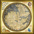
Portolan of Angelo Freducci is a portolan chart by Angelo Freducci from 1554. The portolan belonged to the library of the Zamoyski family. After the Warsaw...
4 KB (257 words) - 20:48, 8 May 2025
1482 maps of Grazioso Benincasa of Ancona as Saluaga/Salvaga (u and v are equivalent) 1460s anonymous Weimar map (attrib. to Conte di Ottomano Freducci of...
13 KB (1,631 words) - 19:26, 12 June 2025

Benincasa; The Italian cartographers of the Benincasa and Freducci Families and the so-called Borgiana Map of the Vatican Library, in Imago Mundi, X (1953), pp...
26 KB (2,793 words) - 06:40, 11 June 2025

Gregory XIII. Portolan of Angelo Freducci Angelo Freducci 1554 The first of two known nautical atlases by Angelo Freducci, a 16th-century cartographer from...
43 KB (742 words) - 17:52, 24 February 2025

Portolan of Antonio Millo (1583) (category 16th-century maps and globes)
carries the inscription Antonius Millo F. M. D. LXXXIII. "Portolan of Angelo Freducci". Polona. National Library of Poland. Retrieved 2024-06-13. Makowski &...
3 KB (244 words) - 20:48, 8 May 2025