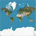
Web Mercator, Google Web Mercator, Spherical Mercator, WGS 84 Web Mercator or WGS 84/Pseudo-Mercator is a variant of the Mercator map projection and is...
16 KB (1,712 words) - 13:28, 25 May 2025
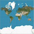
The Mercator projection (/mərˈkeɪtər/) is a conformal cylindrical map projection first presented by Flemish geographer and mapmaker Gerardus Mercator in...
49 KB (6,858 words) - 10:56, 5 June 2025

The transverse Mercator map projection (TM, TMP) is an adaptation of the standard Mercator projection. The transverse version is widely used in national...
40 KB (4,647 words) - 19:20, 21 April 2025

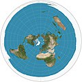
The oblique Mercator map projection is an adaptation of the standard Mercator projection. The oblique version is sometimes used in national mapping systems...
5 KB (555 words) - 00:19, 1 September 2024

a superior alternative to the commonly used Mercator projection, on the basis that the Mercator projection greatly distorts the relative sizes of regions...
18 KB (2,100 words) - 07:18, 2 June 2025

Gerardus Mercator (/dʒɪˈrɑːrdəs mɜːrˈkeɪtər/; 5 March 1512 – 2 December 1594) was a Flemish geographer, cosmographer and cartographer. He is most renowned...
100 KB (12,977 words) - 19:44, 9 May 2025

sphere or ellipsoid. The most well-known map projection is the Mercator projection.: 45 This map projection has the property of being conformal. However...
59 KB (6,451 words) - 10:08, 9 May 2025
ellipsoid) Oblique Mercator projection Space-oblique Mercator projection (a modified projection from Oblique Mercator projection for satellite orbits with...
11 KB (1,211 words) - 00:36, 1 September 2024

Space-oblique Mercator projection is a map projection devised in the 1970s for preparing maps from Earth-survey satellite data. It is a generalization...
4 KB (671 words) - 00:46, 27 May 2024

Positioning System among others. EPSG:3857 - Web Mercator projection of WGS 84, used for display by many web-based mapping tools, including Google Maps...
5 KB (444 words) - 20:42, 28 January 2025

cylindric projection and its virtues, specifically disparaging Mercator's projection.) Weisstein, Eric W. "Cylindrical Equal-Area Projection." From MathWorld—A...
11 KB (723 words) - 18:24, 21 May 2025

22 zoom levels are sufficient for most practical purposes. The Web Mercator projection is used, with latitude limits of around 85 degrees. The de facto...
5 KB (678 words) - 04:55, 19 March 2025
Mercator (Latin for "merchant") often refers to the Mercator projection, a cartographic projection named after its inventor, Gerardus Mercator. Mercator...
2 KB (272 words) - 07:54, 12 November 2024

projection Gall–Peters projection (mentions a resolution rejecting the use of all rectangular world maps) List of map projections Mercator projection...
7 KB (795 words) - 06:47, 9 May 2025

It largely preserves the familiar shapes of the Mercator projection while modestly reducing Mercator's distortion. Polar regions are subject to extreme...
4 KB (547 words) - 10:45, 30 December 2023

map, characterizes the Mercator projection. While the map's geography has been superseded by modern knowledge, its projection proved to be one of the...
153 KB (6,309 words) - 20:31, 8 June 2025

The Miller cylindrical projection is a modified Mercator projection, proposed by Osborn Maitland Miller in 1942. The latitude is scaled by a factor of...
3 KB (324 words) - 17:33, 18 November 2024
illustration of projection, rather than for practical maps. Its vertical stretching is even greater than that of the Mercator projection, whose construction...
3 KB (334 words) - 05:14, 5 May 2025

inspired by the Dymaxion map. The projection does not have some of the major distortions of the Mercator projection, like the expansion of countries in...
6 KB (520 words) - 15:01, 4 March 2025
adopted extensions to the "geo" URI scheme: z: Zoom level for Web Mercator projection scaling. The value is an integer from 1 to 21. q: Perform a search...
15 KB (1,944 words) - 12:22, 20 May 2025

distribution of phenomena. The projection was developed in 1923 by John Paul Goode to provide an alternative to the Mercator projection for portraying global areal...
4 KB (410 words) - 04:26, 5 May 2025

military projection A variation of military projection is used in the video game SimCity Space-oblique Mercator projection Oblique Mercator projection Hatsusaburō...
13 KB (1,586 words) - 09:36, 9 May 2025

Dymaxion map (redirect from Dymaxion projection)
over other projections for world maps. It has less distortion of relative size of areas, most notably when compared to the Mercator projection; and less...
13 KB (1,367 words) - 17:11, 16 April 2025

sinusoidal projection is a pseudocylindrical equal-area map projection, sometimes called the Sanson–Flamsteed or the Mercator equal-area projection. Jean Cossin...
4 KB (464 words) - 22:24, 3 December 2024

phenomena. The projection was developed in 1929 by Samuel Whittemore Boggs (1889–1954) to provide an alternative to the Mercator projection for portraying...
4 KB (407 words) - 00:22, 1 September 2024

parallels (as red lines) on the commonly used Mercator projection and the Transverse Mercator projection. On the former the parallels are horizontal and...
47 KB (6,166 words) - 16:38, 30 May 2025
b. Ahmad al-Sharafi of Sfax in 1571. The projection appears in many Renaissance maps, and Gerardus Mercator used it for an inset of the north polar regions...
12 KB (1,307 words) - 21:10, 25 May 2025

gnomonic projection, also known as a central projection or rectilinear projection, is a perspective projection of a sphere, with center of projection at the...
13 KB (1,522 words) - 21:32, 22 May 2025
This is a summary of map projections that have articles of their own on Wikipedia or that are otherwise notable. Because there is no limit to the number...
32 KB (772 words) - 04:49, 5 May 2025

the equations used to perform the Lambert Conformal Conic and Mercator map projections of CCS83 Lambert Conformal Conic to Geographic Transformation Formulae...
10 KB (1,202 words) - 19:06, 12 October 2024