
50 on 1 April 1963 and the current Route 122 was designated the same day. Japan portal Roads portal "一般国道の路線別、都道府県別道路現況" [Road statistics by General...
2 KB (150 words) - 02:22, 22 March 2024
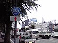
(国道369号, Kokudō Sanbyaku-rokujūkyū-gō) is a national highway of Japan connecting Nara, Nara and Matsusaka, Mie in Japan, with a total length of 122.3 km...
2 KB (79 words) - 21:23, 20 March 2024
National Route 33 (国道33号, Kokudō Sanjūsan-gō), also known as the Tosa Kaidō, is a Japanese highway on the island of Shikoku. It originates at the intersection...
3 KB (211 words) - 02:23, 18 March 2024
National Route 119 (国道119号, Kokudō Hyakujūkyū-gō) is a national highway located entirely within Tochigi Prefecture, Japan. It connects the city of Nikkō...
17 KB (1,298 words) - 10:12, 8 May 2024
National Route 4 (国道4号, Kokudō Yongō) is a major national highway in eastern Honshū, Japan. Measuring 738.5 kilometers long (458.9 mi), it is the longest...
70 KB (1,026 words) - 08:40, 8 May 2024
National Route 58 (国道58号, Kokudō Gojūhachi-gō) is a Japanese national highway connecting the capital cities Kagoshima and Naha of Kagoshima Prefecture...
30 KB (1,850 words) - 10:12, 8 May 2024
National Route 105 (国道105号, Kokudō Hyaku gogō) is a national highway of Japan that traverses the prefecture of Akita in a southwest–northeast routing....
14 KB (746 words) - 18:56, 11 March 2024
National Route 39 (国道39号, Kokudō Sanjūkyū-gō) is a Japanese national highway connecting the two cities of Asahikawa and Abashiri in northeastern Hokkaido...
16 KB (503 words) - 16:50, 15 March 2024
木吉乡 解放前称木吉区,1958年成立八一公社。1978年改称木吉公社。1984年设木吉乡。位于县城以东,距县城48.1千米。面积2406平方千米,人口1.8万,均系维吾尔族。315国道从境内穿过, 行政区划. 皮山县人民政府 (in Simplified Chinese). 18 November 2018. Retrieved 29...
11 KB (962 words) - 08:58, 22 September 2023

National Route 340 (国道340号, Kokudō Sanbyakuyonjūgō) is a national highway of Japan connecting the cities of Rikuzentakata, in southeastern Iwate Prefecture...
10 KB (168 words) - 10:13, 7 August 2023

National Route 121 (国道121号, Kokudō hyaku-nijū-ichi-gō) is a national highway connecting the city of Yonezawa, Yamagata and the town of Mashiko, Tochigi...
2 KB (78 words) - 12:07, 17 June 2022
National Route 5 (国道5号, Kokudō Go-gō) is a major highway on the island and prefecture of Hokkaido in northern Japan. The 288.5-kilometer (179.3 mi) highway...
17 KB (400 words) - 19:13, 11 March 2024

National Route 338 (国道338号, Kokudō San hyaku san jūhachigō) is a national highway in the Japanese prefectures of Hokkaido and Aomori. Route 338 stretches...
9 KB (472 words) - 22:14, 19 June 2022
National Route 104 (国道104号, Kokudō Hyakuyongō) is a national highway of Japan connecting the cities of Hachinohe in southeastern Aomori Prefecture and...
7 KB (218 words) - 10:48, 7 August 2023
"新突破!城开高速控制性工程吴家梁隧道掘进4000米大关_高速公路". www.sohu.com. Retrieved 2020-10-11. "国道109新线饮马鞍隧道开挖进尺突破4000米!". j.021east.com. Retrieved 2022-05-22. 网易 (2021-09-11)...
122 KB (3,503 words) - 12:51, 19 April 2024

and Yonago in Japan, with a total length of 196.4 km (122.0 mi) Japan portal Roads portal "一般国道の路線別、都道府県別道路現況" [Road statistics by General National Highway...
2 KB (76 words) - 18:43, 19 March 2024
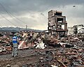
doshakuzure kokudō 8-gō fukkyū mitōshi tatazu Nīgata Jōetsu" 能登半島地震で土砂崩れ 国道8号 復旧見通し立たず 新潟 上越 [Landslide caused by Noto Peninsula earthquake, National Route...
240 KB (23,107 words) - 08:34, 22 May 2024
National Route 122, and this was redesignated as Route 50 on 1 April 1963 when the route was promoted to a first-class highway. "一般国道の路線別、都道府県別道路現況" [Road...
2 KB (101 words) - 02:41, 18 March 2024
National Route 112 (国道112号, Kokudō Hyaku jūnigō) is a national highway of Japan that traverses the prefecture of Yamagata in a southeast–northwest routing...
18 KB (459 words) - 22:34, 6 August 2023

death, 32 injuries; national highway 212 blocked (四川省广元市青川县6.1级余震造成1人死亡32人受伤 国道212线中断)". CEA. August 6, 2008. Archived from the original on August 6, 2008...
162 KB (16,047 words) - 18:54, 22 May 2024

damaged, with dents and some shattered windows. Japan portal Roads portal "一般国道の路線別、都道府県別道路現況" [Road statistics by General National Highway route and prefecture]...
2 KB (183 words) - 08:32, 8 May 2024
"新突破!城开高速控制性工程吴家梁隧道掘进4000米大关_高速公路". www.sohu.com. Retrieved 2020-10-11. "国道109新线饮马鞍隧道开挖进尺突破4000米!". j.021east.com. Retrieved 2022-05-22. "景文3标项目叶麻尖1#隧道顺利进洞施工"...
104 KB (2,809 words) - 20:26, 31 December 2023
National Freeway 1 Traditional Chinese 國道1號 Simplified Chinese 国道1号 Sun Yat-sen Freeway Chinese 中山高速公路...
28 KB (459 words) - 08:14, 21 August 2022

current Route 123 was designated the same day. Japan portal Roads portal "一般国道の路線別、都道府県別道路現況" [Road statistics by General National Highway route and prefecture]...
2 KB (107 words) - 21:59, 19 June 2022