
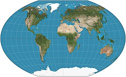
A geological map or geologic map is a special-purpose map made to show various geological features. Rock units or geologic strata are shown by color or...
12 KB (1,563 words) - 19:41, 1 April 2025

Cadastral map Climatic map Geological map Historical map Linguistic map Nautical map Physical map Political map Relief map Resource map Road map Star map Street...
36 KB (4,374 words) - 19:13, 26 June 2025

Engineering geology is the application of geological principles to engineering practice for the purpose of assuring that the geological factors affecting...
87 KB (9,691 words) - 23:10, 27 June 2025
use. Geological maps show not only the surface, but characteristics of the underlying rock, fault lines, and subsurface structures. Choropleth maps use...
9 KB (897 words) - 04:23, 3 June 2025

The geologic time scale or geological time scale (GTS) is a representation of time based on the rock record of Earth. It is a system of chronological...
177 KB (10,097 words) - 19:29, 27 June 2025
Bedrock (redirect from Subsurface (geology))
– the drift-thickness map of Ohio" (PDF). Ohio Geology. No. 1. Ohio Department of Natural Resources, Division of Geological Survey. pp. 1, 3–5. Archived...
6 KB (508 words) - 17:04, 15 June 2025
Geological mapping of Georgia is the creation of geological maps—special-purpose maps made to show geological features—of the State of Georgia in the...
31 KB (4,081 words) - 17:06, 1 April 2025
A geological survey is the systematic investigation of the geology beneath a given piece of ground for the purpose of creating a geological map or model...
4 KB (502 words) - 14:39, 29 August 2024

William Maclure (section Geological map)
of 34 to pursue his scientific, geological and other interests. In 1809 he made the earliest attempt at a geological map of the United States of America...
19 KB (1,958 words) - 06:40, 19 June 2025
Map that Changed the World is a 2001 book by Simon Winchester about English geologist William Smith and his great achievement, the first geological map...
8 KB (1,022 words) - 16:31, 21 February 2025
The United States Geological Survey (USGS), founded as the Geological Survey, is an agency of the U.S. Department of the Interior whose work spans the...
35 KB (3,595 words) - 08:13, 29 April 2025

The Commission for the Geological Map of the World (CGMW or CCGM in French) is an international association in the field of geology. Its main role is the...
8 KB (1,205 words) - 20:29, 1 October 2024

world's first geological map (a map of the United States by William Maclure was published six years earlier), Smith's was the first geological map covering...
27 KB (3,289 words) - 13:11, 26 June 2025
Lanzarote (Mapa Geológico de Canarias)" [Description of the Geological Units of Lanzarote (Geological Map of the Canary Islands)] (PDF). IDECanarias (in Spanish)...
223 KB (20,631 words) - 15:36, 25 June 2025

The Map Book, Weidenfeld & Nicolson, 2005, ISBN 0-297-84372-9, pp. 232, 250. "Organizing the U.S. Geological Survey". The United States Geological Survey:...
20 KB (2,055 words) - 15:28, 25 May 2025

Society in a memoir entitled Observations on the Geology of the United States explanatory of a Geological Map, and published in the Society's Transactions...
17 KB (1,837 words) - 17:56, 22 April 2025

Cartography of the United States (redirect from Map of florida)
published a map of the United States in 1850. The National Program for Topographic Mapping was initiated in 1884 by the United States Geological Survey (USGS)...
2 KB (204 words) - 18:22, 16 June 2025
A thematic map is a type of map that portrays the geographic pattern of a particular subject matter (theme) in a geographic area. This usually involves...
28 KB (3,084 words) - 15:29, 26 May 2025

gravitational field strength, to present data in analogous formats to a geological map. Gravity maps, in a "heat" context, typically represent intensity being representative...
6 KB (498 words) - 17:45, 1 April 2025

geophysical and geological observations made on and below the Earth surface. A geomodel is the numerical equivalent of a three-dimensional geological map complemented...
21 KB (2,258 words) - 20:06, 23 May 2025

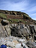
where the fault can be seen or mapped on the surface. A fault trace is also the line commonly plotted on geological maps to represent a fault. A fault...
33 KB (3,760 words) - 21:53, 23 May 2025
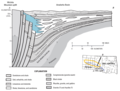
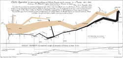
a map of the surrounding region. Cross sections are made by interpreting and extrapolating a broad range of information about a region's geological characteristics...
4 KB (398 words) - 04:26, 26 May 2025

cultural regions began to appear in the 19th Century. The first known geological map of surficial rock types was published by Jean-Étienne Guettard and Philippe...
15 KB (1,738 words) - 15:58, 4 May 2025

Bureau, predecessor to the California Geological Survey, was established, the "roots" of California's state geological survey date to an earlier time. As...
9 KB (1,088 words) - 16:28, 6 June 2025

other regions. Geological maps showing where various formations are exposed at the surface are fundamental to such fields as structural geology, allowing geologists...
10 KB (1,077 words) - 16:07, 1 April 2025


Top Geological Sites (35th International Geological Congress Commemorative Volume), 2016 ISBN 9781775844488 United States Geological Survey maps of the...
5 KB (588 words) - 14:32, 15 September 2024

travelled across Europe, studying geology, as well as ethnology, and is considered to be among the first to produce a geological map of the world. Boué was born...
14 KB (1,359 words) - 15:05, 9 June 2024

term areology is also used by the Areological Society. Figure 2 for the geologic map of Mars Mars is a terrestrial planet, which has undergone the process...
65 KB (7,246 words) - 06:13, 14 June 2025
archaeologists prior to excavation Geological survey, investigation of the subsurface of the ground to create a geological map or model Site survey, inspection...
968 bytes (163 words) - 06:49, 13 May 2025