
Remote sensing is the acquisition of information about an object or phenomenon without making physical contact with the object, in contrast to in situ...
60 KB (7,385 words) - 17:16, 3 June 2025
Remote sensing may also refer to: Remote Sensing (journal), a scientific journal Remote sensing (archaeology) Remote sensing (geology) Remote sensing...
550 bytes (97 words) - 18:09, 13 November 2023
A remote sensing software is a software application that processes remote sensing data. Remote sensing applications are similar to graphics software, but...
3 KB (317 words) - 12:14, 17 June 2023
India's remote sensing program was developed with the idea of applying space technologies for the benefit of humankind and the development of the country...
12 KB (934 words) - 05:14, 7 May 2025
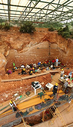
Remote sensing techniques in archaeology are an increasingly important component of the technical and methodological tool set available in archaeological...
16 KB (2,080 words) - 20:20, 3 August 2024
Remote sensing in oceanography is a widely used observational technique which enables researchers to acquire data of a location without physically measuring...
33 KB (4,497 words) - 23:42, 22 May 2025
Radar remote sensing is a type of active remote Sensing which uses electromagnetic energy backscattered from ground targets to extract physical and dielectric...
2 KB (226 words) - 01:28, 24 May 2025
National Remote Sensing Centre (Hindi: राष्ट्रीय सुदूर संवेदन केन्द्र), or NRSC, located in Hyderabad, Telangana is one of the centres of the Indian Space...
2 KB (98 words) - 02:27, 13 March 2025

Wildfire (redirect from Remote sensing of wildfires)
of Remote Sensing, GIS, and Information Distribution for Wildfire Detection and Management" (PDF). Photogrammetric Engineering and Remote Sensing. 64...
200 KB (20,103 words) - 13:28, 28 May 2025

Quantitative remote sensing is a branch of remote sensing. The quantitative remote sensing system does not directly measure land surface parameters of...
5 KB (630 words) - 20:22, 24 May 2025

In electrical engineering, four-terminal sensing (4T sensing), 4-wire sensing, or 4-point probes method is an electrical impedance measuring technique...
5 KB (657 words) - 09:19, 22 January 2023
Remote Sensing Systems (RSS) is a private research company founded in 1974 by Frank Wentz. It processes microwave data from a variety of NASA satellites...
5 KB (473 words) - 15:56, 28 December 2024
The International Society for Photogrammetry and Remote Sensing (ISPRS) is an international non-governmental organization that enhances international cooperation...
17 KB (1,704 words) - 06:54, 17 February 2025

Landsat program (redirect from Land remote-sensing satellite)
director of the United States Geological Survey, proposed the idea of a remote sensing satellite program to gather facts about the natural resources of our...
41 KB (3,817 words) - 14:52, 25 May 2025
The Indian Institute of Remote Sensing (IIRS) was established in the year 1966 under the Indian Department of Space at Dehradun, Uttarakhand. The institute...
5 KB (326 words) - 21:50, 21 May 2025
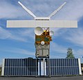
European Remote Sensing satellite (ERS) was the European Space Agency's first Earth-observing satellite programme using a polar orbit. It consisted of...
9 KB (1,004 words) - 22:24, 14 December 2024
The Bangladesh Space Research and Remote Sensing Organization (Bengali: বাংলাদেশ মহাকাশ গবেষণা ও দূর অনুধাবন প্রতিষ্ঠান, romanized: Bangladesh mohakash...
5 KB (501 words) - 10:55, 3 March 2025
Society for Photogrammetry and Remote Sensing (ASPRS) is an American learned society devoted to photogrammetry and remote sensing. It is the United States'...
6 KB (467 words) - 16:43, 5 October 2024
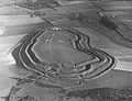
Shadow marks (section Remote sensing applications)
topographic contrast rather than biological or chemical changes. Modern remote sensing techniques—such as LiDAR, NDVI, and Synthetic Aperture Radar (SAR)—are...
29 KB (3,045 words) - 02:28, 2 June 2025
Ground truth (section Remote sensing)
truth data enables calibration of remote-sensing data, and aids in the interpretation and analysis of what is being sensed. Examples include cartography,...
10 KB (1,275 words) - 15:54, 8 February 2025
Ground-based, flight-based, or satellite-based remote sensing instruments can be used to measure properties of the planetary boundary layer, including...
13 KB (1,755 words) - 03:50, 28 January 2024
Ensemble learning (section Remote sensing)
the major applications of Earth observation satellite sensors, using remote sensing and geospatial data, to identify the materials and objects which are...
53 KB (6,689 words) - 11:44, 14 May 2025
Remote Sensing is a semimonthly peer-reviewed open access academic journal focusing on research pertaining to remote sensing and other disciplines of geography...
3 KB (239 words) - 22:01, 12 February 2025

Thermal remote sensing is a branch of remote sensing in the thermal infrared region of the electromagnetic spectrum. Thermal radiation from ground objects...
13 KB (1,276 words) - 20:01, 22 May 2025
Archaeology (section Remote sensing)
reflected. Satellite imagery is an example of passive remote sensing. Here are two active remote sensing instruments: Lidar: Lidar (light detection and ranging)...
134 KB (14,050 words) - 16:53, 3 June 2025
Asian Association on Remote Sensing (AARS) is a non-governmental organization established in 1981 to promote remote sensing in the Asia-Pacific region;...
3 KB (158 words) - 00:15, 27 May 2025
methods. The Center for Remote Sensing and Earth System Sciences (ReSESS) at City Tech focuses on leveraging remote sensing to attract and engage students...
17 KB (2,020 words) - 15:45, 2 June 2025
Journal of Applied Remote Sensing is a peer-reviewed open access scientific journal published by SPIE. It covers all aspects of remote sensing and was established...
2 KB (133 words) - 23:28, 23 February 2024

Field of view (section Remote sensing)
such tomograms by merging multiple slices along the scan range. In remote sensing, the solid angle through which a detector element (a pixel sensor) is...
12 KB (1,555 words) - 13:42, 5 March 2025
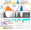
Atmospheric window (section In remote sensing)
surface to leave to space. Atmospheric windows are useful for astronomy, remote sensing, telecommunications and other science and technology applications. In...
9 KB (825 words) - 13:25, 31 October 2024